This item has been sold, but you can get on the Waitlist to be notified if another example becomes available, or purchase a digital scan.
1813 Bruce Map of East Africa showing Solomon's Route to Tarshish and Ophir
OphirTarshish-bruce-1813$225.00

Title
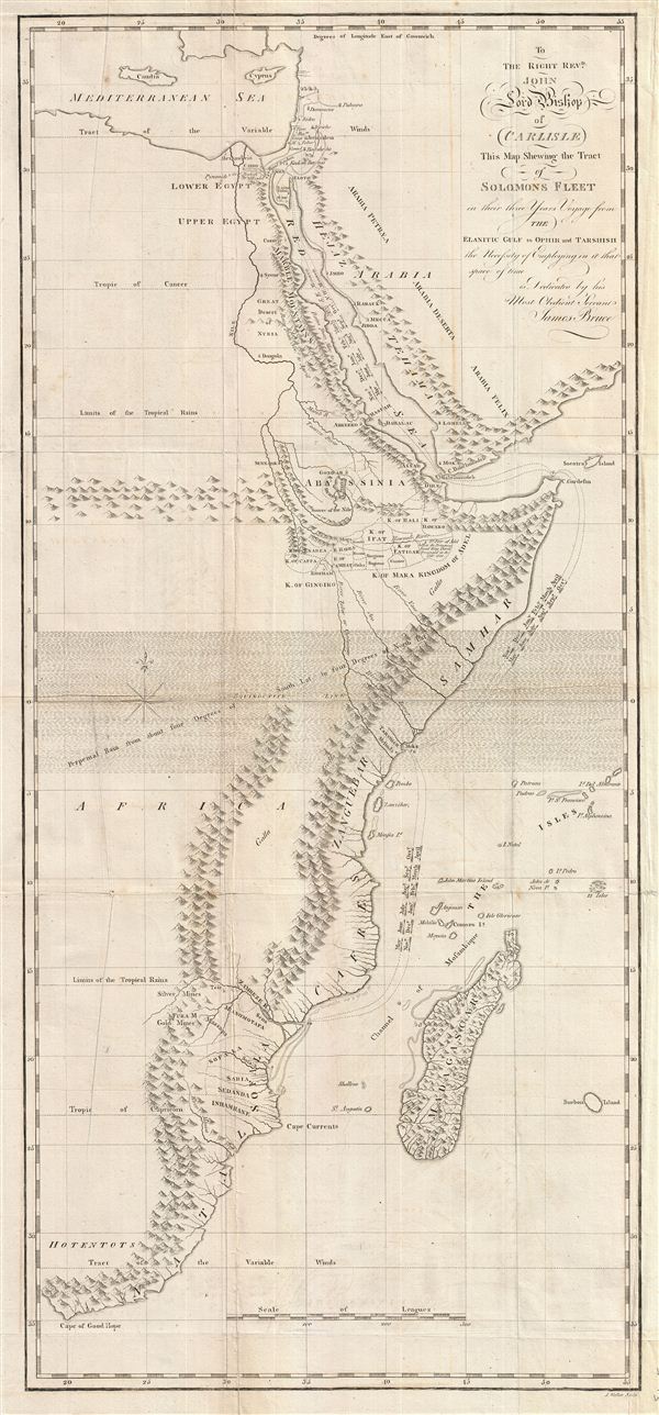
To the Right Revd. John Lord Bishop of Carlisle This Map Shewing the Tract of Solomons Fleet in thir three Years Voyage from the Elantic Gulf to Ophir and Tarshish the Necessity of Empolying in it that space of time is Dedicated by his Most Obedient Servent James Bruce.
1813 (undated) 27 x 12.5 in (68.58 x 31.75 cm) 1 : 12613600
1813 (undated) 27 x 12.5 in (68.58 x 31.75 cm) 1 : 12613600
Description
This is a fascinating, significant, beautifully engraved, intricately detailed 1813 map of eastern Africa, covering from the Mediterranean to the Cape of Good Hope. The map serves to highlight Bruce's speculations, which follow those of Montesquieu, regarding the Biblical ports of Ophir and Tarshish, commonly known as the Lost Mines of King Solomon, from which King Solomon supposedly acquired the massive quantities of gold required to construct the Temple of Jerusalem. Bruce, not illogically, places Ophir in the region of Sofala, near modern day Zimbabwe and Mozambique. Tarshish he sets further north along the Africa Coast near modern day Malindi, Kenya. This region of Sofala (Mozambique / Zimbabwe) did indeed have rich gold and silver deposits in antiquity and in the 16th century was colonized by the Portuguese with the hope of establishing an African gold source to compete with the Spanish discoveries in the Americas. Alas for the Portuguese, by this time the mines of Zimbabwe had long since been depleted. Bruce bases his theories both on Biblical and related literature as well as on his own observations of Indian Ocean weather patterns, particularly the Monsoons.
Many claim that this map and Bruce's explorations in Abyssinia contain a subtext relating to his Masonic and Templar associations. Bruce's ancestor, the Scottish King Robert the Bruce, harbored many of the Knights Templar during their prosecution in the 14th century. Some believe that Bruce inherited secret knowledge that sent him to Ethiopia in search of Templar artifacts including, among other things, the Ark of the Covenant. Bruce himself remained silent on this matter – which is perhaps as telling as not – but to this day many, including most Ethiopians, strongly believe that the Ark resides in the Coptic sanctuary of Axum, which Bruce indeed visited.
Engraved by J. Walker of Cavendish Square for James Bruce's five volume opus, Travels to Discover the Source of the Nile, 1813 edition.
CartographerS
James Bruce (December 14, 1730 - April 27, 1794) was a Scottish explorer, traveler, and nobleman active in the later part of the 18th century. Bruce's romantic adventures in North Africa and Arabia make a tale worthy of Hollywood. Descended from the great Scottish King Robert the Bruce, James Bruce was born at his family seat in Kinnaird, Stirlingshire, Scotland. He was educated in Law at Harrow School and Edinburgh University and, marrying into a family business, became a wine merchant. Following the 1762 war with between England and Spain, Bruce was sent to Algiers with a commission to study Roman antiquities in the region. Many adventures followed that eventually led Bruce to Alexandria, Egypt, where he determined to discover the source of the Nile, which he believed to be in Ethiopia. Bruce traveled up the Nile and, after visiting Luxor worked his way overland to the Red Sea port of Kosseir (Old Cosseir), where he embarked upon a merchant ship disguised as a Turkish sailor. In this guise Bruce made his way to Massawa, where is disembarked and, traveling overland via Axum, arrived at the Abyssinian capital at Gondar. From Gondar, local guides led Bruce southwards to Laka Tana, and then along the Abay River to the Gish Abay springs, the legendary source of the Blue Nile. Bruce believed that the Blue Nile was the Nile of antiquity and claimed, falsely, that it was the larger of the two Nile tributaries. In his narrative Bruce further announced that he had discovered the source of the Nile, while in fact, the first Europeans to visit Gish Abay were the 16th century Spanish Jesuit Pedro Paez and, later, the 17th century Portuguese Jesuit Jeronimo Lobo. On his return journey, Bruce followed the Blue Nile to its confluence with the White, becoming the first European to visit the site. Bruce's explorations were significant and, on his return to Kinnaird, he published a lavishly illustrated narrative of his travels in five volumes. Bruce's tales of Ethiopian architecture, culture, and life where heavily ridiculed by the scholars of this day. Modern researchers, however, have proven that much of Bruce's narrative was substantial and accurate, thus affirming his significant contribution to the cartographic corpus. Snubbed by his peers, Bruce retired to Kinnaird, where he remained until his death in 1794. Modern day conspiracy theorists have added an interesting twist to Bruce's Ethiopian adventures. They claim that Bruce had a second, more important motivation - to rediscover ancient Templar secrets and artifacts hidden in Ethiopia. Some believe that Bruce, having inherited secret Templar knowledge from his ancestor, Robert the Bruce - who sheltered the Templars during their prosecution in the 14th century - was searching Ethiopia for the secrets of the Ark of the Covenant and other religious artifacts. Though Bruce kept silent on what he found, if anything, many Ethiopians maintain that the Ark of the Covenant is, to this day, kept at a sacred sanctuary in Axum. More by this mapmaker...
Longman (fl. c. 1720 - present) is a long lived and venerable British publishing firm initially founded 1720s by Thomas Longman (1699 - 1755). Longman was born in Bristol and in 1716 was apprenticed to John Osborn, a London printer and bookseller. Completing his apprenticeship, Longman requested and was granted the hand of Osborn's daughter. Shortly afterwards Longman acquired the stock of Robinson Crusoe publisher William Taylor and, along with Osborn, established a printing office on Paternoster Row. The two published numerous works including Samuel Johnson's Dictionary. Around the same time that Osborn retired Thomas Longman's nephew, another Thomas Longman (1730 - 1797), joined the firm which was subsequently renamed T. and T. Longman. On the death of the original Thomas Longman, the nephew took over the firm and eventually passed it on to his son, Thomas Norton Longman (1771 - 1842). Thomas Norton seemed to have had a passion for partnering and over the years added Owen Rees (1730 - 1797), Thomas Brown (c. 1777 - 1869), and three more mysterious partners, Hurst, Orme and Green, to the corporation's partner list. For many years the firm published as Longman, Hurst, Rees, Orme, Brown & Green. Thomas Norton eventually passed the firm to his own sons, Thomas and William, who during their tenure bought out most of the minor partners, renaming the firm Longmans, Green & Co. Later, Thomas Longman's son took control of the firm in full naming it just Longman. During World War II most of their plates and stock were destroyed but the company nonetheless survived and went public in 1948. Longman was eventually acquired by the media conglomerate Pearson and continues to publish as Pearson Longman. Learn More...
Source
Bruce, James, Travels to Discover the Source of the Nile, In the Years 1768, 1769, 1770, 1771, 1772 and 1773 (London: Longman, Hurst, Rees, Orme, Brown, and Green) 1813.
Condition
Very good. Some wear and verso reinforcement along original fold lines.
References
Afriterra #1898.