This item has been sold, but you can get on the Waitlist to be notified if another example becomes available, or purchase a digital scan.
1906 Bond and General Land Office Map of Oregon
Oregon-bond-1906$200.00

Title
State of Oregon.
1906 (dated) 29 x 36.75 in (73.66 x 93.345 cm) 1 : 760320
1906 (dated) 29 x 36.75 in (73.66 x 93.345 cm) 1 : 760320
Description
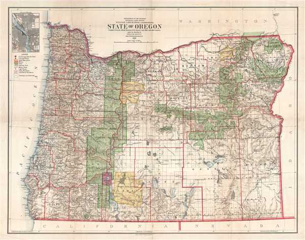
This is a 1906 Frank Bond and General Land Office map of Oregon. The map depicts the state from the Pacific Ocean to Idaho and from Washington to California. Meticulously detailed, the state's organization is presented at several different levels. At a statewide level, not observing any form of governmental organization, are national Forest Reserves, Indian Reservations, and Crater Lake National Park. Illustrated using thick green, yellow, and pink lines and shading with the same colors, these reservations ignore the county boundaries (which are noted by thick red lines and labeled) and may not occupy a full township, but only some of the thirty-six sections within a given township. The township grid is overlaid on the entire map, allowing for easy identification of which parcel of land a certain settler occupies, or wants to occupy. Curiously, some townships have not been subdivided, and these are marked by an 'o' in the center of the township. Even more curious, are the townships that have only been partially subdivided. Cities, towns, and villages throughout the state are labeled, including Salem, Portland, Eugene, and Corvallis. Rivers and streams are also illustrated and labeled, including the Columbia River, the Snake River, and the Willamette River. A legend is situated along the left border, below a small inset map of the City of Portland.
This map was created under the direction of Frank Bond at the General Land Office, compiled by M. Hendges, revised by A.F. Dinsmore, and printed by the Andrew B. Graham Company in 1906.
This map was created under the direction of Frank Bond at the General Land Office, compiled by M. Hendges, revised by A.F. Dinsmore, and printed by the Andrew B. Graham Company in 1906.
CartographerS
Frank Bond (1856 - 1940) was an American cartographer, draftsman, surveyor, illustrator, and politician. Born in rural Jones County, Iowa, Bond graduated from the University of Iowa. In 1772, he moved to Cheyenne Wyoming, where he worked for the Wyoming Surveyor-General's Office and later the General Land Office as a draftsman. He left this position to edit the Cheyenne Tribute and engage in local politics. Bond was elected as a member of the first Wyoming legislature. In 1900, he moved to Washington, D.C., where he held the positions of Chief of the Drafting Division and Chief Clerk at the General Land Office. While at the Land Office, Bond helped determine the borders of Yosemite National Park . As a skilled mapmaker and illustrator, Bond created numerous maps. He was also an active illustrator, painter and ornithologist, creating and preserving bird refuges throughout the country. He had a twin brother, Fred Bond, was also an important surveyor and draftsman. More by this mapmaker...
The General Land Office (GLO) (1812 - 1946) was an independent agency of the United States government responsible for public domain lands in the United States. Created in 1812, it took over functions previously conducted by the Department of the Treasury. The GLO oversaw the surveying, platting, and sale of public lands in the western United States. It also administered the Preemption Act of 1841, which allowed individuals who were already living on federal land to purchase up to 160 acres of land before it was offered for sale to the general public, if they met certain requirements. Following the passage of the Homestead Act in 1862, which was also administered by the GLO, claims under the Preemption Act sharply decreased. The GLO became a part of the newly-created Department of the Interior in 1849. In 1891 Grover Cleveland and Congress created 17 forest reserves, due to public concern over forest conservation, which were initially managed by the GLO, until they were transferred to the Forest Service in 1905. In 1946 the Government Land Office was merged with the United States Grazing Service to become the Bureau of Land Management. Today the Bureau of Land Management administers the roughly 246 million acres of public land remaining under federal ownership. Learn More...
Andrew B. Graham (1845 - September 9, 1909) was an American lithographer active in Washington, D.C. in late 19th and early 20th century. Graham was born in Washington D.C., the son of a lithographer and engraver. After college, he joined the U.S. Coast Survey, where he was a draftsman until 1889. He retired from the Coast Survey to take over management of his father's lithography firm. The firm, Andrew B. Graham Company, was one of several that thrived on lucrative government publication contracts. Graham died of 'brain fever' in his Washington D. C. residence on September 9 of 1909. Some of his work was republished posthumously until about 1917, and his firm was active until at least the early 1920s. Learn More...
Condition
Very good. Even overall toning. Light soiling. Wear along original fold lines. Verso repairs to fold separations. Blank on verso.