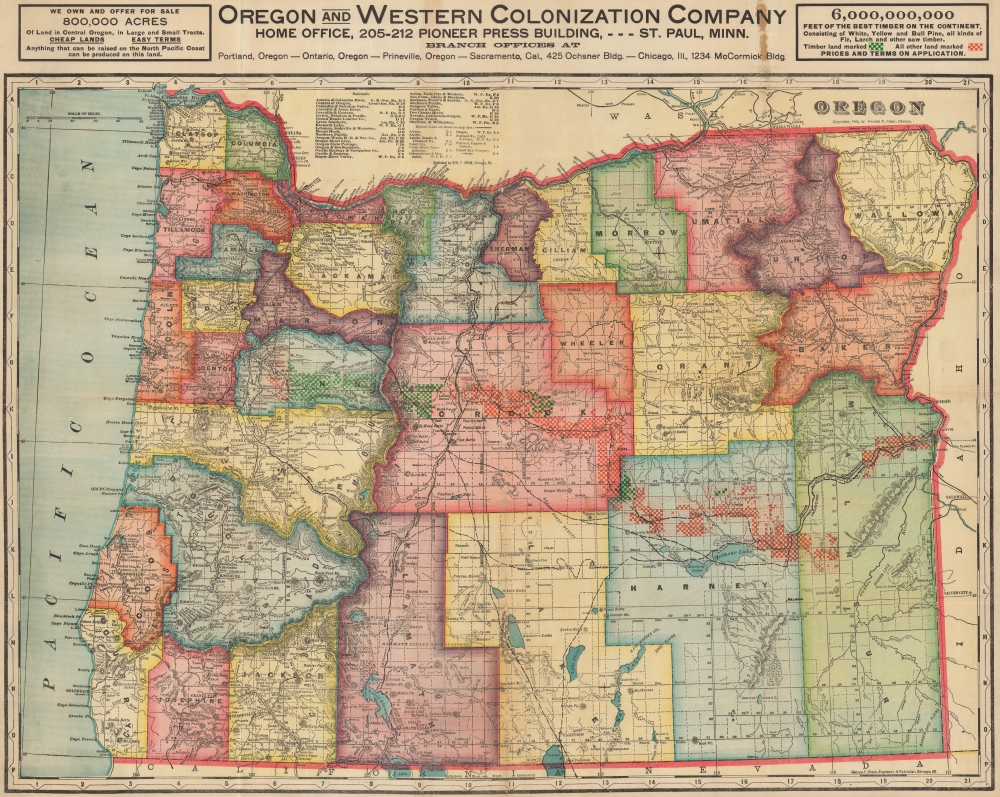
1911 George Cram Map of Oregon and the Oregon and Western Colonization Company
OregonColonization-cram-1911
Title
1911 (dated) 28 x 35.25 in (71.12 x 89.535 cm) 1 : 792000
Description
A Closer Look
Coverage embraces the state of Oregon with red and green checker patterns highlighting land offered for sale by the Oregon and Western Colonization Company - a broad corridor extending from Linn County southeasterly as far as Malheur County. Green acreage is designated for logging, while red marks agricultural land. A key explaining this occupies the upper right corner. Bold black lines illustrate railroads. Cities, towns, and villages are labeled throughout, and an index of railroads and electric railroads appears above the Oregon border.The Oregon and Western Colonization Company
The Oregon and Western Colonization Company (OWC) was founded in May 1910 by investors in St. Paul, Minnesota. It acquired over 800,000 acres of land in central Oregon from the defunct Willamette Valley and Cascade Mountain Wagon Road Company, which they planned to sell to settlers for between $15 and $200 an acre.The Willamette Valley and Cascade Mountain Wagon Road Company
The land grants offered for sale here date to the second half of the 19th century. In 1866, the Willamette Valley and Cascade Mountain Wagon Road Company (WVCM), a well-intended group formed by Linn County farmers, ranchers, and lumbermen, constructed a rough wagon road from Lebanon to Camp Polk (Sisters) on the Deschutes River. Known as the Santiam Wagon Road, the route proved popular, and the WVCM profited handsomely from tolls and road services. When the federal government began authorizing massive land grants to road and railroad builders, the WVCM put in an application that included an exaggerated claim that the existing Santiam Wagon Road was a massive road, built in response to an 1866 congressional bill, that would eventually extend from Albany to the Snake River. The WVDM proposal leveraged kernels of truth with exaggerations, lies, misinformation, and other tricks to maximize their grant. First, they fraudulently claimed a pre-existing road between Albany and Lebanon as their work. Second, they lied about the dates, suggesting that the Santiam Wagon Road was actually built in response to the 1866 bill when it predated the bill considerably. Third, they used the lack of detailed mapping of central Oregon to introduce an erratic, unnecessarily winding route with multiple turns and switchbacks, thus maximizing the area of the grant. Finally, they bribed official agents to 'certify' the unfinished road on the state level, thus confirming the grant.Decades later, in 1880, at least three dozen homesteaders discovered that their lands had been, at least in name, appropriated by the WVCM. In the hope of annulling the grant, they sent an appeal to the Department of the Interior, arguing that the WVCM 'never built or constructed any road as the laws of this State require roads of that character.' They also argued that 'there has been no attempt to open or construct any road' between Smith's Rock and the Snake River, a distance of 300 miles. The Secretary of the Interior sent an investigator who discovered that 'from Cache Creek eastward to the State line it is very manifest that the terms of the grant have not been complied with.' The Department of the Interior nonetheless deferred a decision on the matter to Oregon's state government. Oregon investigated in 1885, and the Secretary of the Interior opened a new investigation in 1887, which concluded that the Willamette Valley road was a 'most unblushing fraud upon the government'. In 1889, the Department of the Interior took the WVCM to court. The Supreme Court ultimately decided in favor of the WVCM, stating that the Congressional bill finalized the grants after the Oregon governor certified the road, which he did despite the lack of actual construction - the roads were certified based on their review by agents, all of which were paid by the WVCM. The ruling confirmed the WVCM's claims to a total of 861,512 acres. Afterward, these lands fell into the hands of French land speculators who took no further action. In 1908, the Oregon and Western Colonization Company (OWC), a group of investors based in St. Paul, Minnesota, purchased rights to more than 800,000 acres of WVCM land encompassing a 12-mile wide strip running from the Willamette Valley to the Idaho border. At the time, this was the largest private land transfer in U.S. history, including
660,000 acres of agricultural and fruit lands, much of which is subject to irrigation and for which water is available, and 140,000 acres of timbered hills. Estimates of the timber place the total at 1,500,000 feet. Thirty thousand acres of the timberland in the Willamette Valley will be subject to fruit-raising as soon as the timber is removed.Newspaper accounts suggest the Oregon and Western Colonization Company sold land to settlers through the 1940s. After about 1944, the company vanishes from record.
Publication History and Census
This map was created by George Cram and published for the Oregon and Western Colonization Company in 1911. We note 4 examples cataloged in OCLC, which are part of the collections at the University of Minnesota Twin Cities, the Oregon Historical Society Research Library, the University of Oregon, and the University of California Berkeley.Cartographer
George Franklin Cram (May 20, 1842 - 1928) was an American map publisher active in the late 19th and early 20th centuries. During the American Civil War, Cram served as a staff cartographer for the Union General Ulysses S. Grant and participated in Sherman's 'March to the Sea'. In 1867, after being discharged from the army, George Cram moved to Chicago, where he founded 'Blanchard and Cram' with his uncle Rufus Blanchard Evanston. Blanchard and Cram was a supply house for the book trade - though they also published a few maps during this period. This short lived business was destroyed in the 1871 by the Great Chicago Fire. After the fire, recognizing a business opportunity in the burgeoning railroad industry, Cram reinvented himself as cartographic publisher, opening the Cram Map Depot. Like fellow Chicago publisher Rand McNally, Cram took advantage of the economical wax engraving processes to inexpensively produce maps in vast quantities. His signature publication, the Unrivaled Atlas of the World became the world's best-selling atlas and was published from the 1880s to 1952. On retiring in 1921, Cram sold his company to Edward A. Peterson of the National Map Company (Scarborough Company). Peterson moved the company to Indianapolis where, following Cram's death, he rebranded the National Map Company as the George F. Cram Company, surely thinking to capitalize on the established identity of the firm. In 1930 he entered the globe market for which the firm was best known from the mid-20th century. In time the firm expanded globally passing becoming a major concern. Loren B. Douthit became company president in 1968 and the Douthit family ran the business until Herff Jones, Inc., bought the company in 2005. More by this mapmaker...


