
1863 Kawachiya / Itamiya Map of Osaka, Japan

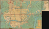
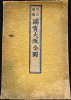
改正增補國寶大阪全圖 / [Revised and Supplemented Complete Map of National Treasure Osaka].
Osaka on the Eve of the Meiji Restoration.
- Digital Map Information
- Suitable for large format printing
- Full resolution TIFF file
- ICC color profile embedded
- Delivered instantly via download link
Osaka on the Eve of the Meiji Restoration.
This is an 1863 large-format woodblock city plan or map of Osaka, Japan, prepared by Kawachiya Tasuke and Itamiya Zenbē. It offers a remarkably detailed overview of the city in the late Tokugawa period, when it was one of Japan's largest and wealthiest cities, second only to Edo (later Tokyo). In this era, Osaka remained a major center of commerce and finance despite heavy damage from an uprising in the 1830s.A Closer Look
This map measures 27.25 x 39 inches, not including the 7 x 10 inch extension on the top-right. It is oriented with north to the left when standing vertically, and with north at the bottom and east at the left when examined horizontally, as in the images above. It presents a dense fabric of named streets and blocks, crisscrossed by waterways, with bridges connecting different parts of the city. Osaka Castle (御城), at the bottom left, is both a cartographically useful and historically important landmark. Built on the grounds of the destroyed Ishiyama Hongan-ji, the castle was constructed by Toyotomi Hideyoshi in the late 16th century and was a key base during his drive to unify Japan for the first time. After Hideyoshi's death, the ascendant Tokugawa Shogunate besieged the remnants of the Toyotomi clan in the castle until both the Toyotomi clan and the castle were destroyed in 1615, crushing the last significant opposition to the Tokugawa.Another landmark, south of the castle (at top-left here), is the Arahakasan Shitennō-ji (荒陵寺山四天王寺), or the Temple of the Four Heavenly Kings. By some accounts, this is the oldest Buddhist temple in Japan, commissioned by Prince Shōtoku in the 6th century and constructed under the guidance of Korean builders from the Baekje Kingdom. The temple complex was damaged by fires, typhoons, and wars over the centuries and was rebuilt multiple times, most recently in 1963, following damage during World War II and a severe 1950 typhoon.
Aside from these most obvious features, the map marks out Buddhist temples and Shinto shrines with red shading. A wide range of building types and fields (野, 畠, or 野畠) are indicated within the city, especially around the castle, while villages are recorded in the hinterland. The map includes a list of distinctive local products (大阪產物名物) and major bridges at the bottom right, while an extension at the top right covers Tenpōzan (天保山), known as 'the lowest mountain in Japan,' and the area later known as Chikko (築港).
Historical Context
Osaka became a major financial center in Japan and home to a large merchant class under Hideyoshi, largely because of the ruler's centralization efforts, including a new taxation system that collected tax in grain (rice). Daimyō from throughout Japan suddenly needed storehouses for their tax rice in Osaka, and the receipts given by the Osaka rice brokers acted as a sort of paper currency. These rice brokers, who famously plied the city's many canals, became immensely wealthy, funding Hideyoshi's military campaigns and public works among other endeavors, and trading on a rice exchange where brokers could buy and sell rice that was not yet harvested, constituting one of the world's first futures markets.Even after the city's conquest by the Tokugawa, it remained an important financial and economic center and benefited from its proximity to Kyoto. Indeed, the Tokugawa even considered moving their capital from Edo to Osaka in the early 17th century. However, the Tokugawa also tended to look down on Osakans, perhaps predictably, seeing them as stingy, dishonest, and decadent and, by contrast, seeing themselves as virtuous, martial, and forthright.
This map shows Osaka after rebuilding from destruction caused by the 1837 Ōshio Heihachirō uprising, which burned a quarter of the city after Ōshio set fire to his own home. The uprising was caused by food shortages (rare in the prosperous Kansai region), high taxes, and dissatisfaction with local officials' corruption and inadequate response to the famine. The shock of losing control over part of Osaka forced the Tokugawa administration to recognize that its system was fracturing. The rebellion directly catalyzed the Tenpō Reforms (1841 - 1843), which sought to dissolve merchant guilds, enforce strict austerity, and regulate prices in major cities. But rather than herald a successful reform program, the Ōshio Heihachirō uprising instead signaled much greater problems to come, as Japan fell into a comprehensive political, economic, social, and cultural crisis in the 1850s and 1860s.
The coming years would witness radical changes - Osaka was opened as a treaty port in 1868 along with nearby Kobe (Hyogo). The same year, the Meiji Restoration shifted the capital to Edo, rechristened Tokyo, and consequently reduced the importance of the Kansai region. Over the following decades, Osaka became Japan's premier industrial powerhouse. Briefly, it eclipsed Tokyo as Japan's largest city in 1930 (helped by a 1925 expansion and annexation of surrounding towns, a measure Tokyo adopted in 1932).
Publication History and Census
This map was issued in 1863 (Bunkyu 3) by Kawachiya Tasuke (河内屋太助) and Itamiya Zenbē (伊丹屋善兵衛) in Osaka (here as Naniwa 浪華). It is recorded as being sold by (書肆) Sekitendō (積典堂). The first part of the map's title, 'Revised and Supplemented' (改正増補), suggests a second or later edition, but we have found no earlier edition, indicating that this prefix was likely a marketing device. This map is cataloged at several institutions in Japan and abroad, but many are 1976 reprints. We have been able to identify original examples of the 1863 map at the University of California, Berkeley (which holds 2 examples); the University of British Columbia; McGill University; Yale University; and eight institutions in Japan.Cartographers
Kawachiya Tasuke (河内屋太助; fl. c. 1735 - 1868) was a publisher based in Osaka that occasionally published maps of Osaka and other sites in the Kansai region. Aside from maps, the firm published local guidebooks and temple guides, directories, historical works, and more, mostly relating to Osaka and its immediate vicinity in the Kansai region. Further Details...
Itamiya Zenbē (伊丹屋善兵衛, 前川善兵衛; c. 1785 - 1941), which was also known by several other names over its history, including Zenbei Maekawa (前川善兵衛) and Bun'eido Itamiya (Maekawa) [文栄堂伊丹屋(前川)], was a publisher based in Osaka. The proliferation of names for the firm is the result of its being an amalgamation of multiple distinct publishers belonging to the Itamiya and Maekawa lineages. The firm was an early adopter of selling books through catalogs and established a reputation as a publisher of Chinese classical works, tea ceremony books, divination books, maps, didactic works, fiction, and later for musical scores. After the Meiji Restoration, the Maekawa family also started to produce musical instruments, educational aids, and school supplies, while the family's publishing arm, rechristened Buneidō Maekawa Shoten (文栄堂前川書店 and later as Maekawa Gōmei Kaisha 前川合名会社 after a fire destroyed its building in 1912), became a leading publisher of educational books and textbooks in Osaka. Further Details...
Condition
Average. Has cellophane tape on both recto and verso. As well as other more modern archival repairs of verso splits.
References
OCLC 21840993.