1817 Thomson Map of the South Pacific and Polynesia
Pacific-thomson-1817$300.00

Title
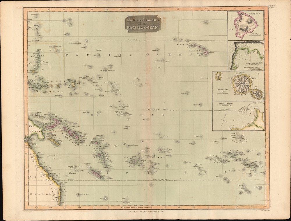
Map of the Islands in the Pacific Ocean.
1817 (dated) 21 x 26 in (53.34 x 66.04 cm) 1 : 16000000
1817 (dated) 21 x 26 in (53.34 x 66.04 cm) 1 : 16000000
Description
This is John Thomson's 1816 map of the Polynesia and the South Pacific. It is one of the few early 19th century maps to focus on Polynesia, despite, in the wake of Cook's travels (and gruesome death), the area being heavily romanticized as an savage paradise in the minds of the British public.
A Closer Look
With a focus on the areas between the Tropic of Cancer and the Tropic of Capricorn, the map embraces the South Pacific from Eastern Australia to (roughly) the Marquesas and from Hawaii to just north of New Zealand. There are insets of the big island of Hawaii (Owhyhee) and Kealakekua Bay (Karakakooa Bay - where Cook was killed), as well as of Tahiti (Otaheite) with Matavai Bay (Matavia Bay - where Cook observed the 1769 Transit of Venus).Publication History and Census
This map was prepared and engraved in 1817 in Edinburgh by Samuel John Neele for inclusion in the 1817 first edition of John Thomson's New General Atlas.CartographerS
John Thomson (1777 - c. 1841) was a Scottish cartographer, publisher, and bookbinder active in Edinburgh during the early part of the 19th century. Thomson apprenticed under Edinburgh bookbinder Robert Alison. After his apprenticeship, he briefly went into business with Abraham Thomson. Later, the two parted ways, John Thomson segueing into maps and Abraham Thomson taking over the bookbinding portion of the business. Thomson is generally one of the leading publishers in the Edinburgh school of cartography, which flourished from roughly 1800 to 1830. Thomson and his contemporaries (Pinkerton and Cary) redefined European cartography by abandoning typical 18th-century decorative elements such as elaborate title cartouches and fantastic beasts in favor of detail and accuracy. Thomson's principle works include Thomson's New General Atlas, published from 1814 to 1821, the New Classical and Historical Atlas of 1829, and his 1830 Atlas of Scotland. The Atlas of Scotland, a work of groundbreaking detail and dedication, would eventually bankrupt the Thomson firm in 1830, at which time their plates were sequestered by the court. The firm partially recovered in the subsequent year, allowing Thomson to reclaim his printing plates in 1831, but filed again for bankruptcy in 1835, at which time most of his printing plates were sold to A. K. Johnston and Company. There is some suggestion that he continued to work as a bookbinder until 1841. Today, Thomson maps are becoming increasingly rare as they are highly admired for their impressive size, vivid hand coloration, and superb detail. More by this mapmaker...
Samuel John Neele (July 29, 1758 - May 13, 1824) was a prolific British map engraver active in the late 18th and early 19th centuries. Neele apprenticed as a printer and engraver with Harry Ashby from about 1781 to 1782 before establishing himself independently in 1785 at 352 Strand, London. The combination of business acumen and technical skill made Neele extremely successful with literally hundreds of maps to his credit. His vast corpus was composed of notable maps by most major English publishers of the period including, Haywood, Faden, Wallis, Stockdale, Arrowsmith, Thomson, Pinkerton, and Greenwood, among others. Neele's sons, James and Josiah Neele, also engravers, took over their fathers business around 1818, both becoming notable in their own right. Learn More...
Source
Thomson, J., A New General Atlas, (Edinburgh: Baldwin, Cradock, Joy) 1817.
Thomson's New General Atlas was first published in 1817 and continued to be published until about 1821. This is the first of Thomson's major cartographic works and the atlas for which is most celebrated. The New General Atlas follows in the Edinburgh School, which eschews excessive decoration in favor of a more minimalistic fact-based cartographic vision, as established by John Pinkerton, Laurie and Whittle, John Cary, and others in the previous decades. The maps are notable for their massive scale, heavy stock, elegant color work, and easy-to-read typefaces. Although the atlas stopped being published after 1821, Thomson continued to offer 'supplementary' maps that could be tipped into the atlas as late as 1830, when he declared bankruptcy. The maps in the Thomson Atlas were engraved by Thomas Clerk, William Dassauville, Nathaniel Rogers Hewitt, James Kirkwood, Robert Kirkwood, John Menzies, George Menzies, Edward Mitchell, John Moffatt, Samuel John Neele, Robert Scott, and James Wyld.
Condition
Good. Original centerfold exhibits some toning.
References
Rumsey 1007.078. Phillips (Atlases) 731. Newberry Library: Ayer 135 T4 1817.