This item has been sold, but you can get on the Waitlist to be notified if another example becomes available, or purchase a digital scan.
1748 Seale Map of the Pacific Ocean w/ Trade Routes from Acapulco to Manila
PacificOcean-ansonseale-1748$375.00

Title
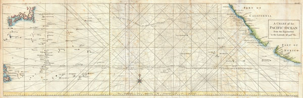
A Chart of the Pacific Ocean from the Equinoctial to the Latitude fo 39 1/2 d. No.
1748 (undated) 11.5 x 35.5 in (29.21 x 90.17 cm)
1748 (undated) 11.5 x 35.5 in (29.21 x 90.17 cm)
Description
This is a rare 1748 nautical chart of the Pacific Ocean by the English map publisher R. W. Seale. Chart depicts the trade routes used by Spanish Galleons from Acapulco, Mexico to Manila in the Philippines. In particular, this chart depicts the travels of the Spanish Nostra Seigniora de Cabadonga and the British Navy Commodore George Anson. Anson lead an ill-equipped expedition into the Pacific with the mission to attack Spanish dominions in South America. Though he failed in this mission, Anson did succeed in capturing the Spanish treasure galleon off Cape Espiritu Santo on June 20, 1743. The Spanish galleon was loaded with gold, silver and, more importantly, nautical charts depicting the trade routes used by Spanish Galleons between Mexico and Manila for the previous 200 years. This significant discovery allowed the British to disrupt Spain's trade in the Pacific and thus economically handicap the Spanish dominance of the New World. Following his capture of the Nostra its treasures were paraded through the streets of London in no less than 32 wagons. Anson was hailed as a national hero. Beautifully details the pacific islands and much of the Mexican and California coast. Drawn by Seale and published as a supplement to the first edition of Anson's 1748 book A Voyage Round The World, In the Years MDCCXL, I, II, III, IV.
CartographerS
Baron George Anson (23 April 1697 - 6 June 1762) was a British commodore and a wealthy noble. Following Anson's aristocratic upbringing on the family estate of Shugborough in Sataffordshire, he joined the British Navy. Anson went through a series of rapid promotions and, in 1737, was given command of a fleet of six ships charged with the mission of attacking Spanish possessions in South America. This mission was ill-equipped and unprepared for the trials ahead. Storms and navigational errors took a heavy toll on the expedition. By the time Anson reached the island of Juan Fernandez his fleet had been diminished to only three ships and his crew reduced to roughly 1/3 of its original strength. Nonetheless, Anson's persistence eventually led to the capture of an immensely rich price, the Spanish treasure galleon Nuestra Senora de Covadonga. The galleon, taken off of Cape Espiritu Santo in 1743 was loaded with silver bullion and, more importantly, charts and maps detailing the routes between Mexico and the Far East used by the Spanish for over 200 years. Knowledge of this route enabled the British navy to disrupt Spanish trade in the Pacific and thus weaken its stranglehold on the Americas. Upon his return to England Anson was hailed as a national hero and made immensely wealthy by his share of the Nuestra's treasure. Anson retired from the Navy for a career in politics and was a Member of Parliament from 1744 to 1747. Anson subsequently continued his naval career with distinction as an administrator, becoming First Lord of the Admiralty (1757-1762). Seven British warships have borne the name HMS Anson in his honor. Anson County, North Carolina, and Ansonborough in Charleston, South Carolina, are also named in Anson's honor. More by this mapmaker...
Richard William Seale (December 1703 - May 25, 1762) was an English a mapmaker and engraver active in London during the middle part of the 18th century. Seale was the son of Richard and Elizabeth Seale. Richard, his father, was a member of the Stationers Company, suggesting that printing and engraving must have been a family trade. Nonetheless, he did not learn the trade from his father, but rather from Samuel Parker of Clerkenwell, to whom he was apprenticed in 1719. Seale was extremely active as an engraver and publisher from about 1740 until his death in 1762. His cartographic corpus is vast; including pieces engraved for most other notable English cartographers of his period: Willdey, Baron, Toms, Rocque, Basire, Bowles, Benning, among others. In addition to cartographic work, Seale also produce numerous architectural engravings. Learn More...
Source
Anson, George. A Voyage Round The World, In the Years MDCCXL, I, II, III, IV, (1748 English Edition).
Condition
Very good condition. Minor repair lower right quadrant. Minor foxing here and there. Blank on verso.
References
National Library of Australia, Map Room, MAP NK 3382/41. National Maritime Museum (London), G266:2/8.