1831 Teesdale Map of the Pacific Ocean
PacificOcean-teesdale-1831$125.00
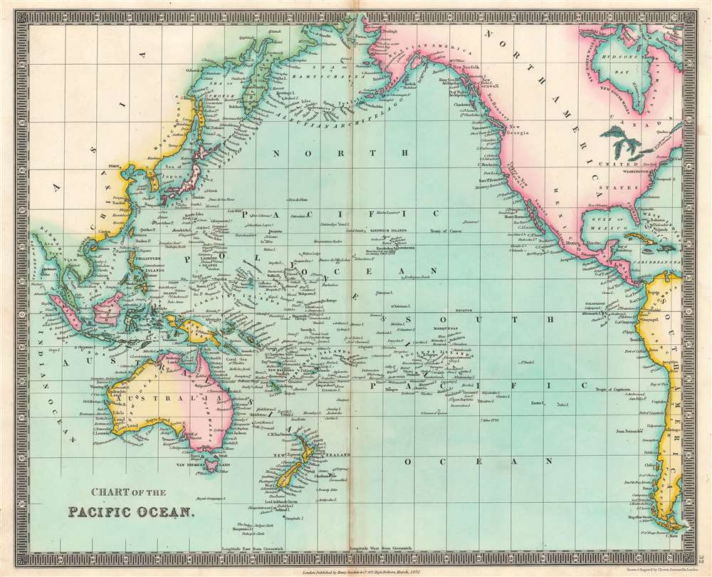

Title
Chart of the Pacific Ocean.
1831 (dated) 13.75 x 16.5 in (34.925 x 41.91 cm) 1 : 55000000
1831 (dated) 13.75 x 16.5 in (34.925 x 41.91 cm) 1 : 55000000
Description
This is an 1831 Henry Teesdale map of the Pacific Ocean, with coverage extending from Asia to the Americas. Islands dot the map, including the Sandwich Islands and 'Owhyhee', the Society Islands, and the Friendly Islands. Unusual names and spellings populate the Pacific Northwest, including, from north to south, 'Alashka', New Norfolk, New Cornwall, New Hanover, and New Georgia. Intriguing regional names appear in Australia as well, such as 'Lions Land', 'Edels Land', 'Nuyts Land', and 'Endrachts Land'.
Publication History and Census
This map was drawn and engraved by John Crane Dower and published by Henry Teesdale in the 1831 edition of his A New General Atlas of the World. The separate map is not cataloged in OCLC. We note three examples of the atlas cataloged in OCLC: The British Library, the University of London, and the Thomas Fisher Rare Book Library in Toronto, Ontario, Canada.CartographerS
Henry Teesdale (December 1776 - January 1856) was a British map publisher active in the first half of the 19th century. Teesdale was born in London. He was elected to the Royal Geographical Society in 1830. Teesdale initially partnered with John Hordan and William Colling Hobson as Henry Teesdale and Company, but this partnership was dissolved in 1832. Afterwards Teesdale continued to publish maps and atlases on his own account. He worked with several major British map engravers of the period including John Crane Dower, Christopher Greenwood, and Josiah Henshall, among others. His most prominent work is a large map of the world engraved by Dower. He must have enjoyed considerable commercial success because in 1845 he is registered as a partner in the Royal Bank of Scotland. Teesdale died in January of 1856 and was buried in All Souls, Kensal Green. More by this mapmaker...
John Crane Dower (1791 - February 20, 1847) was an English engraver, map publisher, and printer active in northern London during the first half of the 19th century. Dower had his office at 6 Cumming Place, Pentonville, London. He was most active as an engraver from 1820 to 1847, where he produced work for John Greenwood, William Fowler, Henry Teesdale, Thomas Moule, Geroge Bradshaw, and others. Dower passed his business on two his two sons, John James Downer, and Fredreric Jamesd Dower. Learn More...
Source
Teesdale, H., A New General Atlas of the World..., (London: Teesdale) 1831.
Condition
Very good. Light wear along original centerfold.