1581 Ortelius Maps of Padua and Apulia in Italy
PaduaApulia-ortelius-1573$500.00

Title
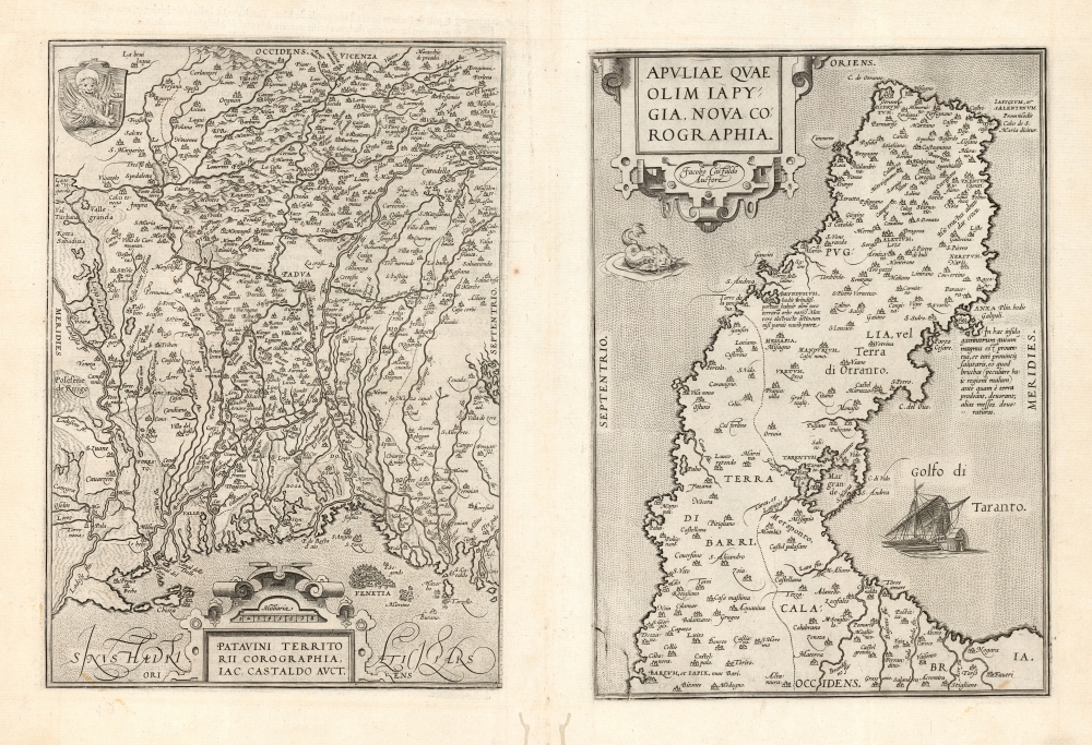
Patavini Territorii Corographia, Iac Castaldo Auct./ Apuliae Quae Olim Iapygia, Nova Corographia. Jacobo Castaldo Auctore.
1573 (undated) 12.25 x 19 in (31.115 x 48.26 cm) 1 : 270000
1573 (undated) 12.25 x 19 in (31.115 x 48.26 cm) 1 : 270000
Description
This is Abraham Ortelius' 1573 engraving containing maps of the Italian regions of Padua and Apulia: respectively, the immediate region inland of Venice and the bootheel of Italy. Both maps Ortelius credits to the 16th century Italian doyen of geography, Giocomo Gastaldi; the map illustrates the transmission to the Low Countries of both the traditional medium and the content of 16th century Italian geography.
Padua and Venice
The left-hand panel presents a westward-oriented map of the North Italian region centered on Padua, a complex network of rivers emptying into the Gulf of Venice. Venice itself appears at the bottom, eastern limit of the map. The top or westward extreme of the map embraces Vicenza. The leonine arms of Venice embellishes the upper left hand corner.Apulia
The second map is an eastern-oriented map of the bootheel of Italy, with the Gulf of Venice to the north and the Gulf of Taranto to the south. The map includes a notation with respect to the port of Brindisi (explaining that it was once a great port, but had become clogged and would only admit small boats.) A note discussing the island of Anxa on the Gulf of Taranto describes its large bird population, and their exceedingly useful diet of troublesome locusts. The sea of Venice is prowled by a sea monster, while a war galley sails Taranto.Publication History and Census
These two largely unrelated maps were engraved to a single plate to be printed together; although the plate was divided sometime in 1579, the maps were thereafter kept in the same order in Ortelius' Theatrum. This example conforms to the 1581 French text edition, of which van den Broecke estimates there were 400 printed. In various editions, the separate map is well represented in institutional collections.CartographerS
Abraham Ortelius (April 14, 1527 - June 28, 1598) also known as Ortels, was a cartographer, geographer, and cosmographer of Brabant, active in Antwerp. He was the creator of the first modern atlas, Theatrum Orbis Terrarum and is a seminal figure in the history of cartography. Along with Gerard Mercator and Gemma Frisius, he was a founder of the Netherlandish school of cartography. His connections with Spain - culminating in his 1575 appointment as Royal Cartographer to King Phillip II of Spain - gave him unmatched access to Spanish geographical knowledge during a crucial period of the Age of Discovery. Ortelius was born in 1527 in Antwerp. In 1547 he entered the Antwerp Guild of Saint Luke as an illuminator of maps. He began trading in books, prints, and maps, traveling regularly to the Frankfurt book and print fair, where in 1554 he met Mercator. He accompanied Mercator on journeys throughout France in 1560 and it was at this time, under Mercator's influence, that he appears to have chosen his career as a scientific geographer. His first published geographic work appeared in 1564, an eight-sheet cordiform world map. A handful of other maps preceded the 1570 publication of the first edition of the Theatrum Orbis Terrarum, which would prove to be his life work. Appearing with but 53 maps in its first edition, Ortelius' work expanded with new maps added regularly. By 1592, it had 134 maps. Many of Ortelius' maps remained the standard for nearly a century. He traveled extensively, but his genius was as a compiler, locating the best informed maps on which to base his own. His contacts throughout Europe and extending even (via the Portuguese) to the Far East were formidable. Moreover, many of his maps were based on his own scholarship, particularly his historical works. His theories of geography were particularly ahead of his time with respect to the notion of continental drift, the possibility of which he mused on as early as 1596, and which would be proven correct centuries later.
In a sense his greatest achievement was his successful navigation of the religious and political violence endemic to his city throughout his adult life: The Dutch Revolt, or Eighty Years' War (1568 - 1648), fully embroiled Antwerp. Although outwardly and officially recognized as Catholic (Arias Montanus vouched for Ortelius' Catholic orthodoxy prior to his appointment as Royal Geographer), Ortelius was able to separate himself from the religious furor which characterized the war in the low countries. Ortelius showed a glimpse of himself in a letter to a friend, regarding humanist Justus Lipsius: 'I do not know whether he is an adherent of the Pope or a Calvinist, but if he has ears to hear, he will neither be one nor the other, for sins are committed on both sides'. Ortelius' own explorations of Biblical history in his maps, and the Christogram contained in his own motto, suggest him to be a religious man, but his abjuration of political religious authorities mark him as an individualist. His tombstone at St Michael's Præmonstratensian Abbey in Antwerp bears the inscription, Quietis cultor sine lite, uxore, prole. ('served quietly, without accusation, wife, and offspring.') More by this mapmaker...
Giacomo Gastaldi (c. 1500 - October, 1566) was an Italian astronomer, cartographer, and engineer active in the second half of the 16th century. Gastaldi (sometimes referred to as Jacopo or Iacobo) began his career as an engineer, serving the Venetian Republic in that capacity until the fourth decade of the sixteenth century. During this time he traveled extensively, building a large library relating to voyages and exploration. From about 1544 he turned his attention to mapmaking, working extensively with Gextantiovanni Battista Ramusio, Nicolo Bascarini, and Giovanbattista Pedrezano, as well as taking private commissions for, among others, Venice's Council of Ten. He is credited with the fresco maps of Asia and Africa still extant in the map room of the Doge's Palace. Gastaldi was also one of the first cartographers to embrace copper plate over woodblock engraving, marking an important development in the history of cartography. His 1548 edition of Ptolemy's Geographia was the first to be printed in a vernacular; it was the first to be printed in copperplate. As with his Swiss/German contemporary Münster, Gastaldi's work contained many maps depicting newly discovered regions for the first time, including the first map to focus on the East Coast of North America, and the first modern map of the Indian Peninsula. His works provided the source for the vast majority of the Venetian and Roman map publishers of the 1560s and 70s, and would continue to provide an outsize influence on the early maps of Ortelius, De Jode, and Mercator. Learn More...
Source
Ortelius, A., Theatre de l'univers, contenant les cartes de tout le monde, (Antwerp: Plantin) 1581.
Abraham Ortelius' magnum opus, Theatrum Orbis Terrarum, was the world's first regularly produced atlas, which 'set the standards for later atlases . . . It was the first undertaking of its kind to reduce the best available maps to an uniform format.' (Koeman) A modestly-sized work of fifty-three maps in its first edition of May 1570, it was an immediate success: there were three further editions that year, and the work remained in print for a total of 32 editions, the last of which was 1641, well after its author's 1598 death. Ortelius added to his atlas constantly, and by 1595 the Theatrum contained 147 maps. Ortelius is renowned generally as an editor, and indeed much of the Theatrum is compiled from a variety of sources: in such cases, Ortelius was scrupulous in naming his sources. But Ortelius was also a mapmaker in his own right: many of his maps are a distillation of various sources into his own work, and there were many maps - particularly in his atlas of Biblical and ancient history Parergon - which were entirely Ortelius' work. In his role as an editor, Ortelius followed in the footsteps of Munster, whose Cosmographia was, until Ortelius, the best window on the world for the curious European reader. In terms of the artistry of his maps, Ortelius oversaw the first great flourishing of copperplate engraving in the service of cartography to occur in Northern Europe. Ortelius' work provided the model for the atlases of Mercator, Hondius, Blaeu and all their progeny in the 17th century - many of whom were to produce faithful editions of Ortelius' maps in their own productions.
Condition
Very good. Filled wormholes near lower centerfold not impacting printed image. Else fine.
References
OCLC 605321671. van den Broecke, M., Ortelius Atlas Maps, #121 A and B.