This item has been sold, but you can get on the Waitlist to be notified if another example becomes available, or purchase a digital scan.
1750 Homann Heirs Map of Israel / Palestine / Holy Land (12 Tribes)
Palestina-homannheirs-1750$325.00

Title
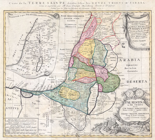
Palaestina in XII Tribus divisa cum Terris Adiacentibus…
1750 19 x 21 in (48.26 x 53.34 cm)
1750 19 x 21 in (48.26 x 53.34 cm)
Description
This is one of the Homann Heirs finest and most appealing maps of Palestine / Israel / The Holy Land. Depicts the region divided into the 12 Tribes of Israel. In the right hand corners there are two title cartouches. The lower is exceptionally decorative and depicts with two spies of Moses bearing the fruit from the Promised Land to the Hebrew camp, as well as the front and back of an ancient shekel coin. The upper left quadrant offers an overview of the region as a whole. The upper right features a dedication from the mapmaker to Karl Wilhelm Ferdinand, the future Duke of Braunschweig-Wolfenbüttel and Braunschweig-Lüneburg (from 1773). This map was drawn by Johann Christoph Harenberg.for inclusion the 1752 Homann Heirs Maior Atlas Scholasticus ex Triginta Sex Generalibus et Specialibus…. Most early Homann atlases were 'made to order' or compiled of individual maps at the request of the buyer. However, this rare atlas, composed of 37 maps and charts, was issued as a 'suggested collection' of essential Homann Heirs maps. A fine copy of an important map.
Cartographer
Homann Heirs (1730 - 1848) were a map publishing house based in Nuremberg, Germany, in the middle to late 18th century. After the great mapmaker Johann Baptist Homann's (1664 - 1724) death, management of the firm passed to his son Johann Christoph Homann (1703 - 1730). J. C. Homann, perhaps realizing that he would not long survive his father, stipulated in his will that the company would be inherited by his two head managers, Johann Georg Ebersberger (1695 - 1760) and Johann Michael Franz (1700 - 1761), and that it would publish only under the name 'Homann Heirs'. This designation, in various forms (Homannsche Heirs, Heritiers de Homann, Lat Homannianos Herod, Homannschen Erben, etc..) appears on maps from about 1731 onwards. The firm continued to publish maps in ever diminishing quantities until the death of its last owner, Christoph Franz Fembo (1781 - 1848). More by this mapmaker...
Condition
Very Good condition. Very minor centerfold discoloration. Blank on verso.
References
Phillips, Lee Philip, A List of Geographical Atlases in the Library of Congress, page 44.