
1965 al-Sayyad Propaganda Map of Palestine recording the Nakba

This item has been sold.
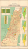
خريطة فلسطين بين الانتداب والنهاب / [Map of Palestine Between the Mandate and the Plunder.] / فلسطين العربية قبل النكبة / [Arab Palestine Before the Nakba.]
Documenting the Nakba.
Documenting the Nakba.
This is a rare 1964 Egyptian-issued Arabic-language map of Palestine and Israel illustrating the Nakba, the Palestinian term meaning 'Catastrophe'. The map illustrates the demographic transition from a primarily Arabic population in 1920 to a mainly Jewish population by 1964, with an emphasis on the dramatic changes brought on by the 1948 Arab-Israeli War. The content further undercuts the ongoing tensions that, in 1967, would erupt in the Six-Day War.A Closer Look
The primary map, covering most of modern-day Israel / Palestine, is a statistical chart that offers population analysis as of the printing date, 1964. The map breaks out four population groups: Jews, Palestinians, Druze, and Christians, noting that the last three are all Arabs. Statistical diagrams appear at left, illustrating the change from a primarily Arab to a primarily Jewish demographic between the years of 1920-1948-1964. The imagery is admittedly not flattering to the Jewish populace and can be considered anti-Semitic. The diagrams nonetheless underscore the dramatic effect of the 1948 Arab-Israeli War and subsequent population shift, which came to be known among Palestinians as the Nakba (النَّكْبَة, [Catastrophe]).Plans for Partition
Three maps at right illustrate alternative plans for partition.- Upper map (1937 Peel Commission): First official partition proposal dividing Palestine into an Arab state (green) and a Jewish state (yellow), with a British-controlled corridor (red) including Jerusalem and Tel Aviv.
- Middle map (1947 UN Partition Plan, Resolution 181): Proposed separate Arab (green) and Jewish (yellow) states with a U.N.-administered international zone around Jerusalem (red). Accepted by Jewish leadership, but rejected by Arab leaders, precipitating the 1948 Arab-Israeli War.
- Lower map (Post-1948, Armistice of 1949): Shows Israel (yellow) controlling most of the territory; Palestinian-held areas in the West Bank and Gaza (green); and demilitarized zones (striped) near Jerusalem, along the Egyptian border, and around Lake Tiberias.
The Nakba
The Nakba has its roots in the 1947 - 1949 Palestine War, when an estimated 700,000 Palestinians either fled their homes or were expelled. This is approximately eighty percent of the Palestinian Arab population living in what is today Israel. Between 250,000 and 300,000 had done so before Israel declared independence, which the Arab League viewed as a justifiable cause for war. This led to the 1948 Arab-Israeli War. During the 1947 - 1949 war, the Israelis depopulated and destroyed as many as 500 Palestinian villages. The Palestinian names for these locations were immediately erased and replaced with Hebrew names. Numerous non-Jewish historical sites were also destroyed in the subsequent decades, including the destruction of over 80% of village mosques. The Nakba also rendered the Palestinians stateless, following an Israeli law voiding Palestinian citizenship, declaring their citizenship 'devoid of substance.' The Nakba also fractured Palestinian society, leading to a Palestinian diaspora.Publication History and Census
This map was drafted by the renowned Egyptian geographer Mohamed Mahmoud Al-Sayyad (محمد محمود الصياد). It was printed in Alexandria, Egypt, by the Moharram Industrial Printing Company (شركة مطابع محرم الصناعية بالإسكندرية). Scarce. We see a sole institutional holding at the National Library of Israel. There are likely additional holdings in Arab institutions, but we have not been able to isolate them definitively.Cartographer
Mohamed Mahmoud Al-Sayyad (محمد محمود الصياد; December 1916 - 1982) was a prominent Egyptian geographer, author, poet, and academic. Born in Balteem, Gharbia Governorate, he received a traditional early education, completed his secondary studies in Tanta, and in 1939 graduated first in his class with a degree in Geography from Cairo University. He earned his Ph.D. from Durham University in 1948, focusing on the economics and political development of Sudan. Al-Sayyad taught at Cairo University, helped establish King Saud University in Riyadh, and later led the Geography Department at Ain Shams University before becoming Dean of the Institute for African Studies and Research at Cairo University in 1974. A prolific writer, he published over 60 works on geography, culture, and society, as well as poetry, including The Master of Rivers in Nile Geography and Then Came Autumn. A member of the Egyptian Scholarly Academy, he was awarded the State Encouragement Prize in 1967 and the State’s Grand Prize in 1978 for his contributions to social sciences. Further Details...
Condition
Very good. Sight reinforcement of a few minor fold splits.
References
National Library of Israel 990038731640205171.