This item has been sold, but you can get on the Waitlist to be notified if another example becomes available, or purchase a digital scan.
1852 Philip Map of Palestine / Israel / Holy Land
Palestine-philip-1852$150.00

Title
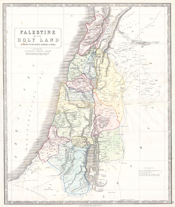
Palestine or the Holy Land According to its Ancient Divisions & Tribes.
1852 20 x 24 in (50.8 x 60.96 cm)
1852 20 x 24 in (50.8 x 60.96 cm)
Description
This beautiful hand colored map is a steel plate engraving of Israel / Palestine or the Holy Land. Depicts the region as it would have been during the period of the Twelve Tribes of Israel. There are numerous notations referencing well, caravan routes and Biblical locations. Dated 'Liverpool, Published by George Philip and Sons 1852.'
Cartographer
George Philip (1800 - 1882) was a map publisher and cartographer active in the mid to late-19th century. Philip was born into a Calvinst family in Huntly, Aberdeenshire, Scotland. Around 1819 he apprenticed himself to William Grapel, a Liverpool printer and bookseller. Fifteen years later, in 1834, Philip founded his own Liverpool book and map firm. Philip's earliest cartographic ventures were mostly educational material issued in tandem with John Bartholomew Sr., August Petermann, and William Hughes. In 1848, Philip admitted his son, George Philip Jr. (1823 - 1902) into the firm, renaming it George Philip and Son Ltd. George Philip Jr. ran the firm until his death in 1902, by which time it had developed into a major publishing concern. His successors established the London Geographical Institute, a factory where they embraced modern printing techniques to produce thousands of economical and high quality maps. In April 1988, George Philip & Son was acquired by Octopus Publishing, a branch of Reed International. Nonetheless, today the firm trades and publishes to this day as George Philip and Son. More by this mapmaker...
Condition
Very good condition. Minor closed and repaired tears to margins. Blank on verso.