This item has been sold, but you can get on the Waitlist to be notified if another example becomes available.
1968 Dolph Map of Palm Beach, Florida
PalmBeach-dolph-1968$175.00


Title
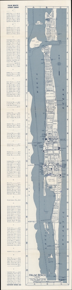
Palm Beach Florida / Indexed Street Map of Palm Beach Florida.
1968 (undated) 7 x 30 in (17.78 x 76.2 cm) 1 : 22000
1968 (undated) 7 x 30 in (17.78 x 76.2 cm) 1 : 22000
Description
A detailed indexed folding map of Palm Beach, Florida, published c. 1968 by the Dolph. It catalogs the city's many hotels, motels, clubs, and other attractions, many of which were noted for their distinctive architecture.
Though not noted on this map, the Mar-a-Lago Club, most famous for being the residence of former President Donald Trump, is located between Woodbridge Rd. and Southern Blvd., near the Southern Blvd. Bridge. In the early 1960s, John F. Kennedy also used his family's residence, dubbed 'La Querida' (located at 1095 N. Ocean Blvd., between Monterey Rd. and Colonial Ln.), as a 'Winter White House'.
A Closer Look
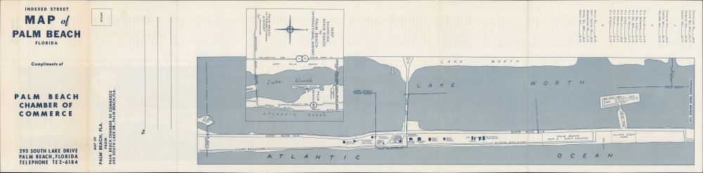
Displaying the entirety of Palm Beach in a strip format, the map is surrounded by a grid corresponding to a street index at left. The southernmost portion of Palm Beach is displayed in a continuation in a different orientation on the verso, along with an inset depicting roads leading to Palm Beach International Airport. Hotels, motels, golf courses, clubs, docks, and theaters are highlighted, along with museums, parks, churches, libraries, a casino, and other attractions or public institutions. Bridges and pathways through the Intracoastal Waterway are also indicated. Streets are labeled throughout, including recent additions - Sandpiper Dr. and Tradewinds Dr., just north of the Palm Beach Country Club - stamped in after printing.Though not noted on this map, the Mar-a-Lago Club, most famous for being the residence of former President Donald Trump, is located between Woodbridge Rd. and Southern Blvd., near the Southern Blvd. Bridge. In the early 1960s, John F. Kennedy also used his family's residence, dubbed 'La Querida' (located at 1095 N. Ocean Blvd., between Monterey Rd. and Colonial Ln.), as a 'Winter White House'.
Palm Beach and the Florida Land Boom
At the turn of the 20th century, industrialist and founder of Standard Oil Henry Flagler (1830 - 1913) built his Florida East Coast Railway and extended it to the Miami region on the state's southeastern coast. Flagler built several hotels in Palm Beach, deeming the area a paradise that was sure to impress others as much as it had him. He liked the area so much that he built a stately mansion called Whitehall (here as the Flagler Museum) and encouraged other grandees to do the same, at least for seasonal residences. With the height of the Florida Land Boom in the 1920s, dozens of structures in the Mediterranean or Spanish Revival and Beaux Arts styles were constructed throughout the city, with Art Deco buildings being added somewhat later. As was the case elsewhere in South Florida, preservation efforts began in the 1970s and 1980s, and now more than 300 buildings and other sites in Palm Beach are protected.Publication History and Census
This map was published by the Dolph Map Company as a promotional mailer for the Palm Beach Chamber of Commerce. It is undated, but from the hotels, must date to the mid-late 1960s. It is recorded in the OCLC among the holdings of the Library of Congress, the State Library of Florida, and the University of California Santa Barbara.Cartographer
Frank B. Dolph (October 3, 1897 - November 26, 1975) was an American businessman and map publisher. Born in Great Neck, Long Island, New York, Dolph served as a Navy storekeeper during World War I. He began selling maps in 1919 after returning from England, likely for the George F. Cram Company, where he ultimately became an administrative aide. He also worked for the Rand McNally Company for some time before he founded his own map publishing firm, Dolph and Stewart, with his friend, sometime in the 1920s. Dolph and Stewart made maps throughout the 1920s and 1930s until they sold the firm in 1945 when Dolph decided to return to Florida. Dolph opened a new map publishing business, the Frank B. Dolph Map Co. in Ft. Lauderdale and published city plans of cities throughout the United States. Many of his maps were distributed by Chambers of Commerce or sold at newsstands. Real estate developers greatly appreciated his maps, those published by both the Dolph and Stewart Company and the Frank B. Dolph Company. Dolph retired as president of his firm around 1965, when he handed the business off to his son, Frank B. Dolph, Jr. Dolph worked with cartographer Theodore M. Politano for decades while operating the Frank B. Dolph Map Company. More by this mapmaker...
Condition
Very good. Light wear along original folds. Small number of handwritten annotations.
References
OCLC 5481373.