1758 Tirion Map and Nautical Chart of New Guinea, Raja Ampat Islands
Papoasche-tirion-1753$275.00

Title
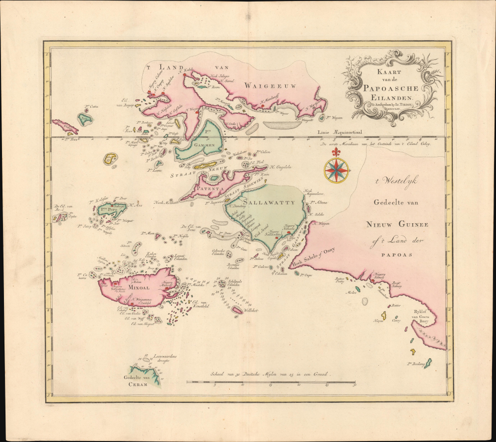
Kaart van de Papoasche Eilanden.
1753 (dated) 13 x 15 in (33.02 x 38.1 cm) 1 : 1500000
1753 (dated) 13 x 15 in (33.02 x 38.1 cm) 1 : 1500000
Description
This is Isaak Tirion's colorful 1753 Dutch map and nautical chart of the Dampier Strait, the Bird's Head Peninsula of West Papua, and the Raja Ampat Islands in what is now eastern Indonesia. The strategically important waterway was at the far edge of (indirect) Dutch colonial rule, but was crucial to Dutch hegemony over the Spice Islands.
A Closer Look
Coverage includes the Dampier Strait (named for the English navigator William Dampier, here as Straat Neeuw) and surrounding islands, situated along the Equator. At top is Waigeo, among the larger islands in the area, while other islands (Mansaur, Batanta, Salawati, Misool) are easily recognizable today, even with different names and spellings. At right is the westernmost tip of Irian Jaya (West Papua), known as the Bird's Head or Doberai Peninsula (Vogelkop in Dutch). At bottom-left is a portion of Seram (Ceram), one of the main islands of the Maluku Islands (Moluccas).Historical Context
Unlike Java or Batavia, or even the nearby Maluku Islands, these islands had minimal direct contact with Europeans until the 20th century. Individual islands ruled by their own rajas often traded with the generally-Dutch-aligned sultanates of Bacan, Ternate, and Tidore, and through them began to adopt Islam, but otherwise remained autonomous. Nominally, Waigeo and surrounding islands were under Dutch suzerainty via Tidore since the late 17th century, but in practice, this meant little (still, when the Dutch invaded Maluku in the early 19th century, they deemed the Raja Ampat Islands to be included in their conquest). Primarily, the Dutch were interested in protecting their control over the coastal waterways and straits threading through the islands, above all the Dampier Strait, crucial to preventing a rival power like the Spanish, Portuguese, English/British, or French from attempting to gain control of the region.Publication History and Census
This map was prepared by Isaak Tirion and is dated 1753, but it was published quite a bit later (c. 1770) in Tirion's Nieuwe en Beknopte Hand-Atlas, bestaande in eene Verzameling van eenige der algemeenste en nodigste Landkaarten.... Six institutions independently catalog the map in the OCLC: the Newberry Library, the University of Hawaii at Manoa, Cornell University, the Bibliothèque nationale de France, the State Library of New South Wales, and the National Library of Australia.Cartographer
Isaak Tirion (1705 - 1765) was a Dutch publisher in Amsterdam. Born in Utrecht, Tirion quickly rose to prominence by publishing pamphlets, historical works, and most importantly, maps and atlases. He produced several atlases and Dutch town plans. His maps are mainly based on those of Guillaume de l'Isle. Tirion eventually relocated his printing house to the prestigious Kalverstraat. In his long career, he produced eight atlases in multiple editions, some of which were published posthumously until about 1784. More by this mapmaker...
Source
Tirion, I., Nieuwe en Beknopte Hand-Atlas, bestaande in eene Verzameling van eenige der algemeenste en nodigste Landkaarten, (Amsterdam) c. 1770.
Condition
Excellent. Original centerfold.
References
OCLC 4896088.