1863 De Brayer Map of Paraguay
Paraguay-brayer-1863$7,000.00


Title
Carte de la Républiuque Du Paraguay dédiée et présentée à sa Majesté Napoléon III Empereur des Français, par le Comte Lucien de Brayer Consul de France au Paraguay.. Publiée pat en 1863.
1863 (dated) 50 x 33 in (127 x 83.82 cm) 1 : 1036000
1863 (dated) 50 x 33 in (127 x 83.82 cm) 1 : 1036000
Description
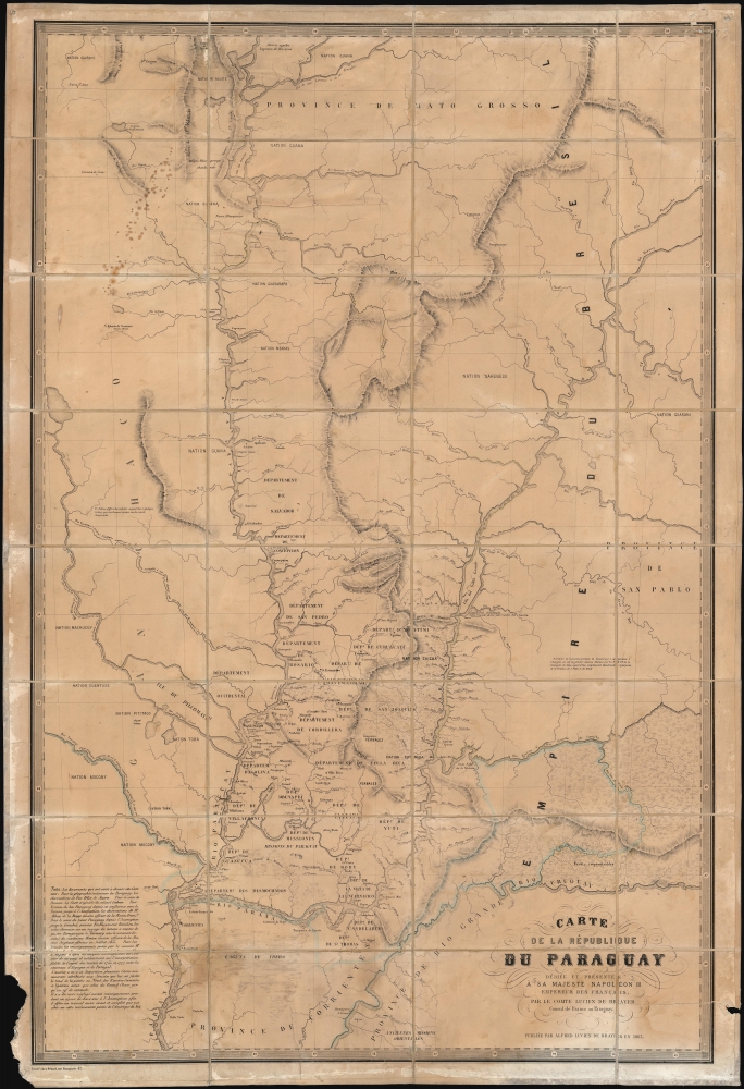
This is an extremely rare 1863 map of Paraguay, produced by Alfred Lucien de Brayer, Napoleon III of France's consul to the South American country. It was published to commemorate the 10th year of France's diplomatic recognition of Paraguay's independence, and probably as an attempt to bolster de Brayer's damaged reputation with the Emperor. The map is superbly detailed, laying out Paraguay and its frontier regions. It details the administrative regions within the country; neighboring indigenous tribes and nations are noted as well as the bordering regions of Brazil and Argentina.
It was also agreed to establish a French consulate in Asunción, and the Emperor appointed Count Lucien de Brayer to the post. He arrived November 20, 1854, and served until he was replaced by Count Alfred de Brossard in 1856.
De Brayer credits the mapping of Brazil's frontier to a 'scholar, Mr. d'Angelis, based on his long investigations into the history of these countries and in particular the faithful interpretation of the treaties of 1750 and 1777 between the crowns of Spain and Portugal'. This is almost certainly a reference to Pedro de Angelis' 1852 Memoria historica sobre los derechos de soberania y dominio de la Confederacion Argentina a la parte austral del continente Americano ('Historical memoire on the rights of sovereignty and dominion of the Argentine Confederation to the southern part of the American continent'). This Neapolitan historian and newspaper publisher, an emigrant to Buenos Aires, was a member of both the Paris Société de Géographie and the Royal Geographical Society, and De Brayer had access to his work before even crossing the Atlantic; likely the Jesuit sources he refers to also were available to him before his time in Paraguay. De Brayer is at pains to point out that 'Moreover, he did not neglect any information during a two-year stay at the Assumption in order to offer as exact and complete a work as possible on this interesting part of South America'. Even so, these are all sources that would have been available to him during his tenure as Consul, and which would have informed him at that time. It is then probable that the map was composed during that period: it does not reflect the period between De Brayer's removal as Consul and its publication in 1863.
The colony in Nueva Burdeos was a source of trouble for De Brayer, and probably destroyed him. The land assigned the colonists was poor, difficult to cultivate, and exposed to attacks from the indigenous population. The colonists were additionally dismayed to find Carlos Lopez' decree that forbade Paraguayan citizens from leaving the country on pain of death applied to them. De Brayer's protests against this draconian policy were ineffectual, and eventually the colonists petitioned to be allowed to leave: ultimately they were allowed to do so, albeit destitute. Virtually his whole term as Consul was spent in the advocacy for the French Colonists, which endeared him neither to Lopez nor the colonists. In 1856, he left Asunción due to ill health and was replaced by the Count de Broussard. Since De Brayer was producing this map for presentation to Napoleon III, he was probably keen to emphasize his knowledge of the place's geography and remain silent about his failures.
France's First Consul to Paraguay
The first dictator of Paraguay, Gaspar Rodríguez de Francia (1766 - 1840), El Supremo from 1814 to 1840, was recognized only by France. The government of Carlos López (1792 - 1862) gained legitimacy by recognition in the 1840s by Brazil, Chile, Bolivia, Uruguay, and Venezuela; and in 1852, Argentina. European recognition came more slowly: Austria in 1847, with England and France following suit in 1853. Following French recognition of Paraguay, a 'Treaty of Friendship, Commerce and Navigation' was signed on March 4, 1853, by the representative of Emperor Napoleon III, Chevalier Léonce de Saint-Georges, and President López' son Francisco Solano (1826 - 1870). The following year, Francisco - who would succeed his father, disastrously - visited Paris for the treaty's ratification and was personally received by Napoleon III.It was also agreed to establish a French consulate in Asunción, and the Emperor appointed Count Lucien de Brayer to the post. He arrived November 20, 1854, and served until he was replaced by Count Alfred de Brossard in 1856.
The Sources
De Brayer's map is distinct from contemporaneous maps in its detail, but its author credits his sources for the different elements of the map in the text of the work. For the interior of the country, he claims to have drawn on the observations - dating from about 1809 - of Felix de Azara (1746 - 1821). De Brayer nods to Jose Maria Cabrer (1761 - 1836) for the course of the Parana, but his 1853 work can also be recognized on the west bank of the Paraguay River - an important area, as this was the riverine access to the contested Chaco in which the French colony of Nuevo Burdeos would be established. The former French Navy officer Alban de la Berge, whom de Brayer credits for the course of the Paraguay from its confluence with the Parana to Asunción, we have been unable to trace. But the points upstream to Coimbra come from a journey there in 1855 performed by the steamship Tacuarí, then commanded by the English officer George Francis Morice. (Tacuarí, a recent Paraguayan purchase from England, had in 1854 been sailed by Morice to Paraguay carrying Francisco Solano López and his delegation, returning from his mission to Napoleon III. It is very probable that De Brayer was also aboard when the vessel first arrived in Asunción on January 21, 1855. To become the new flagship of the Paraguayan Navy, command passed from Morice to Pedro Ignacio Meza in 1856.)De Brayer credits the mapping of Brazil's frontier to a 'scholar, Mr. d'Angelis, based on his long investigations into the history of these countries and in particular the faithful interpretation of the treaties of 1750 and 1777 between the crowns of Spain and Portugal'. This is almost certainly a reference to Pedro de Angelis' 1852 Memoria historica sobre los derechos de soberania y dominio de la Confederacion Argentina a la parte austral del continente Americano ('Historical memoire on the rights of sovereignty and dominion of the Argentine Confederation to the southern part of the American continent'). This Neapolitan historian and newspaper publisher, an emigrant to Buenos Aires, was a member of both the Paris Société de Géographie and the Royal Geographical Society, and De Brayer had access to his work before even crossing the Atlantic; likely the Jesuit sources he refers to also were available to him before his time in Paraguay. De Brayer is at pains to point out that 'Moreover, he did not neglect any information during a two-year stay at the Assumption in order to offer as exact and complete a work as possible on this interesting part of South America'. Even so, these are all sources that would have been available to him during his tenure as Consul, and which would have informed him at that time. It is then probable that the map was composed during that period: it does not reflect the period between De Brayer's removal as Consul and its publication in 1863.
Absence of the French Colonies in Paraguay
Among French goals was to establish a colony in the region, and de Brayer's service was taken up in attempting to negotiate the safety and freedom of the French colonists during the increasingly xenophobic and capricious Carlos Lopez regime. The first of these colonies was established in the Chaco, across the Paraguay River from Asunción in Nueva Burdeos (New Bordeaux). Other sites would be attempted: the González colony in Caazapá and the Nueva Picardia colony on the border with Brazil. Bafflingly, de Brayer's map pictures none of these - but portrays instead a 'Colonie Française' south of the Parana in the Corrientes.The colony in Nueva Burdeos was a source of trouble for De Brayer, and probably destroyed him. The land assigned the colonists was poor, difficult to cultivate, and exposed to attacks from the indigenous population. The colonists were additionally dismayed to find Carlos Lopez' decree that forbade Paraguayan citizens from leaving the country on pain of death applied to them. De Brayer's protests against this draconian policy were ineffectual, and eventually the colonists petitioned to be allowed to leave: ultimately they were allowed to do so, albeit destitute. Virtually his whole term as Consul was spent in the advocacy for the French Colonists, which endeared him neither to Lopez nor the colonists. In 1856, he left Asunción due to ill health and was replaced by the Count de Broussard. Since De Brayer was producing this map for presentation to Napoleon III, he was probably keen to emphasize his knowledge of the place's geography and remain silent about his failures.
Publication History and Census
The map was printed by Georges Erhard Schièble (Erhard in his imprint) in 1863 as a separate issue. We are aware of a later, probably 1865 edition produced by Lemercier. It is extremely rare: we see one example in the Staatsbibliothek zu Berlin and another in the University of Texas at Austin.CartographerS
Alfred Lucien de Brayer (1816-1894) was a French Count, a draughtsman, painter, and diplomat. He served as French consul to Paraguay beginning in 1855, an appointment he received from Napoleon III. He had initially been tasked with the creation of a French colony across the Paraguay river from Asuncion; he would later struggle to maintain support the interests of French colonists in the face of the increasingly capricious and xenophobic regime of Franciso Solano López. He came from a military family. His grandfather, the French general Michel-Sylvestre Brayer (1769 - 1840), had distinguished himself under Napoleon and paid for his loyalty with exile until 1821: Michel-Sylvestre would begin his family's association with South America, serving with a variety of armies, indluding that of Jose Miguel Carrera in Chile. Michel-Sylvestre's son Lucien de Brayer (1794–1865) was born in Germany and followed his father's trade: in 1828 he commanded a regiment of the Republic of Montevideo, and was a high-ranking officer in Greece supporting the rebellion there against Turkish rule. He died died a military officer in Uruguay in 1865. More by this mapmaker...
Azara, Félix de (May 18, 1742 - October 20, 1821) was a Spanish military officer, naturalist, and engineer. He joined the Army, and received training as an engineer in a Spanish military academy. His thirteen year career in the Army would see him promoted to Brigadier General. He spent twenty years in the Rio de la Plata region of South America as a delegate under the treaty of San Ildefonso, during which period he undertook to create an accurate map of the region. On the surveys, he also recorded the fauna the region, in particular cataloguing nearly four hundred species of bird. On his return to Europe in 1801 he wrote and published in Paris his Voyage dans l'Amerique meridionale depuis 1781 jusqu'en 1801 (1809) which contained his observations on the region's geography, natural features, and indigenous groups. His work was praised for thoroughness and accuracy, and was well regarded by Darwin. He died of pneumonia on October 20, 1821. Learn More...
Condition
Good. Few mended tears; marginal loss not impacting printed image, toning, else very good.
References
OCLC 49201416.