This item has been sold, but you can get on the Waitlist to be notified if another example becomes available, or purchase a digital scan.
1920 Leconte Pocket Map of Paris, France ( with Eiffel Tower and Metro)
Paris-leconte-1820$125.00

Title
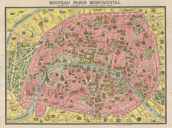
Nouveau Paris Monumental Inineraire Pratique de L'Etranger Dans Paris.
1920 (undated) 21 x 27 in (53.34 x 68.58 cm)
1920 (undated) 21 x 27 in (53.34 x 68.58 cm)
Description
A later example of the famous 'Nouveau Paris Monumental' tourist pocket map of Paris. Covers Paris from the Bois de Boulogne to the Bois de Vincennes. Monuments and important buildings are shown in relief - including the Eiffel Tower. Also shows roadways and Metro lines. Though undated, the state of development of the Paris Metro, particularly the extension of the 11, suggests that this map must have been printed around 1920 - 1925. Verso offers a similar map of the greater Paris area extending as far as Chartres, Bray, Vignes and Beauvais. Folds into original, though battered, red paper binder
Cartographer
André Leconte (fl. 1880 - 1930) was a Paris based guidebook and map publisher active in the latter part of the 19th and early 20th centuries. He is one of the publishers of the attractive art nouveau style "Nouveau Paris Monumental" series. Leconte is often associated with L. Guilmin, another Paris based map publisher of the same period. Early in World War II (1939 - 1945) the firm published anti-German propaganda, but briefly shut down operations during the occupation. Leconte's name appears on maps and guidebooks of Paris well after his death (though we can't date this event with any precision) to about 1980. More by this mapmaker...
Condition
Very good. Minor wear on original folds. Map of the greater Paris vicinity on verso. Folds into original paper binder.