This item has been sold, but you can get on the Waitlist to be notified if another example becomes available, or purchase a digital scan.
1839 Piquet Folding Case Map of Paris, France
Paris-picquet-1839$1,400.00

Title
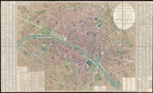
Plan Routier de la Ville de Paris, divise en XII Arrondissements ou Mairies et en Quarante Huit Quartiers, avec tous le Changements et Projets ordonnes par le Gouvernement.
1839 (dated) 33 x 55 in (83.82 x 139.7 cm) 1 : 7500
1839 (dated) 33 x 55 in (83.82 x 139.7 cm) 1 : 7500
Description
This is a stunning large format map of Paris issued in 1839 by Pierre-Jacques Picquet. Centered on the Seine River, the map covers from the Champ de Mars eastward to Place du Trone. This map was first issued for administrative use during the Napoleonic era in November 1804 by Pierre-Jacques' father, Charles Picquet. It was the first of a series of maps designed to illustrate the many grand civic works and reconstructions that redefined Paris under the French Emperor Napoleon I, and the subsequent Bourbon Restoration monarchs, Louis XVIII, Charles X, and Louis Philippe I. Thus the exceptionally meticulous original color work referencing the detailed Explication des Couleurs in the lower left quadrant which identifies public buildings, monuments in progress, and monuments completed, mansions, town halls, and more. Issued here in 1839, this map chronicles some 30 years of rapid civic construction throughout Paris.
The Picquet's were remarkable in their tenacity with which they maintined and grew their government sponsored publishing contracts throughout the French Revolution, the Napoleonic Era, and the Bourbon Restoration. Early editions were dedicated to Joachim Murat, Marshal of the Empire and brother-in-law to the Emperor Napoleon I. After the fall of Napoleon, Picquet reworked the dedication to honor the Duc D'Orleans and the King of France, at the time Louis Philippe I.
The Picquet's were remarkable in their tenacity with which they maintined and grew their government sponsored publishing contracts throughout the French Revolution, the Napoleonic Era, and the Bourbon Restoration. Early editions were dedicated to Joachim Murat, Marshal of the Empire and brother-in-law to the Emperor Napoleon I. After the fall of Napoleon, Picquet reworked the dedication to honor the Duc D'Orleans and the King of France, at the time Louis Philippe I.
Cartographer
Charles Picquet (April 15, 1771 – January 15, 1827) was a French cartographer active in Paris during the Napoleonic and post-Napoleonic Eras. Picquet was born in Romagna-sous-Montfaucon, Meuse, France. From about 1798 Picquet supplied maps to the Dépôt de la Guerre. From 1806 he was appointed to Napoleon's Cabinet Topographique. Being politically dexterous, he was able to retain this position after the fall of Napoleon under both Louis XVIII and Charles X. Under Louis XVIII he also obtained the Brevet de Géographe Ordinaire du Cabinet Topographique. He worked with the cartographer Adrien-Hubert Brué on a major atlas project. When Charles Picquet died in 1827, his son, Pierre-Jacques Picquet, continued to publish under his father's imprint name well into the middle part of the 19th century. More by this mapmaker...
Condition
Very good. Original linen.
References
OCLC 977596219.