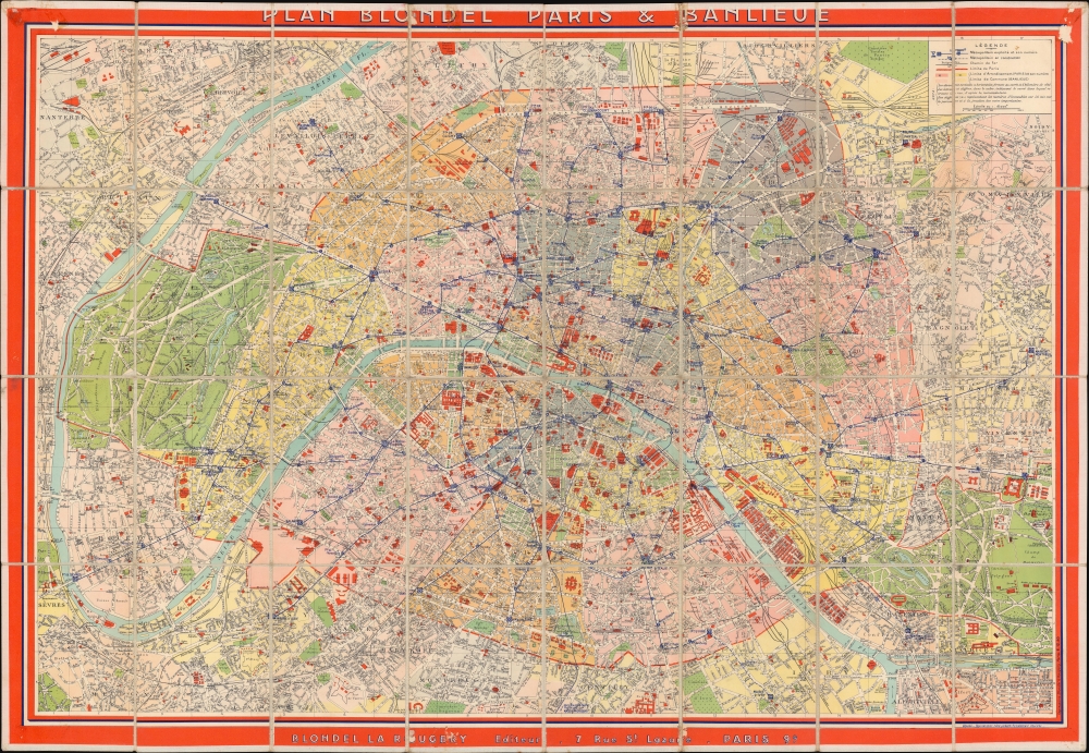
1942 Blondel la Rougery City Plan or Map of Paris, France
ParisBanlieue-blondellarougery-1942$950.00


Title
Plan Blondel Paris et Banlieue.
1942 (undated) 29.25 x 39.5 in (74.295 x 100.33 cm) 1 : 18000
1942 (undated) 29.25 x 39.5 in (74.295 x 100.33 cm) 1 : 18000
Description
This is a c. 1942 Editions Blondel la Rougery city plan or map of Paris, France. The map illustrates Paris during the World War II (1939 - 1945) Nazi occupation. The name on the back, Capt. Franklin G. Fischrist (or possibly Tischrist), suggests it was used by an English or American officer after the war.
A Closer Look
Depicting Paris from the Seine east to the Chateau de Vincennes and from St. Ouen south to Gentilly, Ivry, and Montrouge, buildings throughout Paris are illustrated and shaded orange. These structures range from monuments such as the Eiffel Tower, the Arc de Triomphe, Notre Dame, and the Louvre to train stations, hospitals, and schools. The Jardin des Tuileries, the Jardin du Luxembourg, the Jardin des Plantes, the Parc des Buttes Chaumont, the Bois de Boulogne, and the Bois de Vincennes appear as open green spaces. Streets, roads, and alleys are labeled. The Paris Métro appears as bold blue lines, with blue text and numbers marking each stop. We have dated this map using the Paris Métro based on the extent of construction.An Unknown Provenance
On the verso, Captain Franklin G. Tischrist (sp?) signed just above the Editions Blondel la Rougery bookplate. Unfortunately, we have been unable to trace this Captain, making it impossible to know his story.Publication History and Census
This map was published between July 1939, when Métro Line 10 was extended to the Gare d'Austerlitz (not explicitly labeled here, but the extension is printed) and October 1942, when Métro Line 8 was extended from Porte de Charenton to Charenton-Écoles, which appears here as a dashed line indicating that it remains under construction. We have been unable to locate any other verifiable examples of the present edition. Blondel la Rougery published numerous editions of this map beginning as early as 1916 using the same title, making differentiating challenging. Nonetheless, we note an example of the 1944 edition with the Line 8 extension illustrated as a solid blue line at the Bibliothèque nationale de France.Cartographer
Blondel la Rougery was a French publishing house founded in Paris around 1902 by the publisher and aerophile Édouard Blondel la Rougery (July 9, 1877 - July 20, 1955). The company specialized in maps and books, particularly those related to aviation and maritime themes. Over time, Blondel la Rougery became well-known for its detailed maps, which were used extensively during both World Wars. In 1934, the firm inherited the aviation and cartographic copyrights of Georges Besançon (1866 - 1934), erstwhile publisher of L'Aérophile. In 1955, his son Max Blondel la Rougery took over the business and continued to manage it until 1976. The company continued to operate until the early 21st century, with its focus remaining largely on map production. The publisher’s works are notable for their precision and artistic quality, making them highly regarded in both historical and cartographic circles. More by this mapmaker...
Condition
Good. Dissected and mounted on linen in 32 panels. Old tape residue on verso. Areas of scuffing to corners and in top and bottom edges in printed title and copyright.