This item has been sold, but you can get on the Waitlist to be notified if another example becomes available, or purchase a digital scan.
1889 Garnier Pictorial Map of Paris, France w/Monuments
ParisMonumental-garnier-1889$187.50

Title
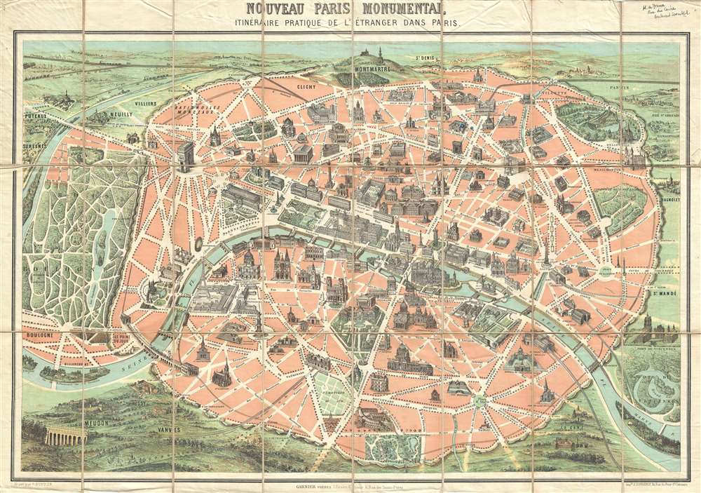
Nouveau Paris Monumental Inineraire Pratique de L'Étranger Dans Paris.
1889 (undated) 21 x 27 in (53.34 x 68.58 cm) 1 : 15000
1889 (undated) 21 x 27 in (53.34 x 68.58 cm) 1 : 15000
Description
An iconic c. 1889 tourist pocket map of Paris, France. Presented as a same field birds-eye view, this map centers on the Seine River, and covers the embastilled heart of modern Paris. Issued as a tourist piece for the 1889 Exposition Universelle, which introduced the Eiffel Tower, buildings and monuments shown in profile, including the Eiffel Tower, the Arc de Triomphe, Sacre-Coeur, the Pantheon, etc. Paris itself is set as if in a verdant garden surrounded by the Bois de Boulogne, the Bois de Vincennes, and various suburban villages. In the north, under a blue sky, rolling hills stretch indefinitely into Normandy towards the English Channel.
A Cinematographer's Perspective
Tom Conley, referencing the map in his brilliant discussion on cartographic influences in cinema describes it beautifully,…the north, at the top, is capped by the Sacre-Coeur; the station at the Port d'Orleans marks a southern limit; to the west the maze of alleys in the Bois de Boulogne offers a fantasy of infinite promenades under leafy trees; to the east, at the Place de la Triomphe de la Republique, is found a sculpture celebrating secular France, that is protected by the moat-like circle of a subway line. A railway inside of a circular, crenelated wall of mediaeval aspect surrounds much of the city. Blocks of pink, denoting the inner space of the city, are cut by a broad swath of white lines indicating the width and length of Baron Haussmann's creation of boulevards. The Seine, colored in blue, bends its way through Paris, dividing the Right Bank (above) from a lesser mass of the Left Bank (below). The major monuments of the city are finely drawn and situated at their proper places. Yet their scale, of far greater proportion than that of the map itself, make clear that he city is an assemblage of enduring monuments…And indeed Paris is a tableau of modern punctuated, as with the illustrated monuments, by a long and fascinating history as a center of commerce, education, arts, and culture.
Publication History and Census
Issued in various forms from about 1867 to 1950, his map has along and interesting publication history that has received little attention from map historians and other scholars – mostly likely because of the profound difficulty in assessing the date of the individual maps, none of which are dated, and the multitude of variants issued by numerous firms. Having dealt with many versions of this map, we believe we may have pieced together a tentative history. This map is based upon an 1867 map engraved by Hilaire Guesnu and published by Auguste Logerot for the Exposition Universelle of that year. That map is distinctive for introducing various iconic elements that would remain with the series well into the 20th century – namely the same-field bird's-eye view perspective, monuments rendered in profile, general coverage, and more, but is printed using a steel plate process. The map appears to have been subsequently adapted by F. Dufour and Garnier Frères using a more modern chromolithograph process and issued sometime prior to the 1878 Exposition Universelle, and is notable for having a blank Champs de Mars. It was again issued by Dufour and Garnier for the 1878 Exposition Universelle with updates around the Champs de Mars referencing the event. Another Garnier edition was prepared for the 1889 Exposition Universelle, in which the Eiffel Tower is added to the Champs de Mars. Around 1900 various other firms began copying the Garnier / Dufour model, including Leconte, Guilmin, Robelin, Hachette, and others. Also, around this time the map was co-opted to illustrate the Paris Métro system, which was initiated in 1900. Post-1900 variants can be more easily dated by referencing the development of the Métro system. These editions also did away with some of the map's iconic qualities, including the bird-eye view aspect to the surrounding countryside.Cartographer
Garnier Frères (1833 - June, 1983) was a prominent publishing house and bookstore based in Paris, France. The publishing firm was founded in 1833 by the brothers Auguste (1812 - 1887) and Hippolyte Garnier (1815 or 1816 – 1859, photo at right). Their younger brother Pierre-Auguste (1807 – 1899) also joined the firm. Yet another brother, Baptiste-Louis Garnier (1822 - 1893) joined in 1844. The popular Paris bookshop, located in the arcades of the Palais-Royal in the gallery Peristyle Montpensier, followed shortly after in 1838. They opened another location in 1853 in the former government hotel, at the corner of rue de Lille and rue des Saints-Pères. The firm prospered through the publication of low cost editions French classics. Their corpus of work includes maps, guides, novels, historical works, and essays. In June of 1983 the firm filed for bankruptcy and their assents were taken over by Presses de la Cité, a subsidiary of InfoMédia, which was itself liquidated in 2000. More by this mapmaker...
Condition
Good. Some edge wear. Dissected and mounted on linen.
References
OCLC 40581734, 35147263, 71594885. Conley, Tom, Cartographic Cinema, (Minneapolis: University of Minnesota Press, 2007), 141-2. Vallee, Leon, Catalogue des plans de Paris et des cartes de I'lle de France, (Paris: Bibliotheque Nationale, 1908),172, nos. 1306 - 1311.