This item has been sold, but you can get on the Waitlist to be notified if another example becomes available, or purchase a digital scan.
1915 Garnier Pictorial Map of Paris, France w/Monuments
ParisMonumental-garnier-1915$150.00

Title
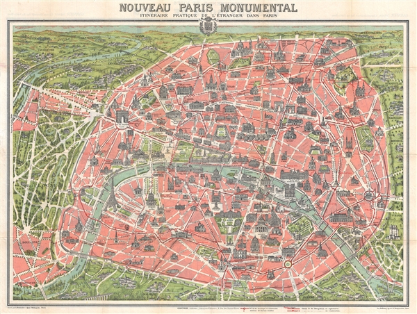
Nouveau Paris Monumental Inineraire Pratique de L'Etranger Dans Paris.
1915 (undated) 21 x 27 in (53.34 x 68.58 cm) 1 : 15000
1915 (undated) 21 x 27 in (53.34 x 68.58 cm) 1 : 15000
Description
An iconic c. 1915 tourist pocket map of Paris, France. Presented as a same field birds-eye view, this map centers on the Seine River, and covers the embastilled heart of modern Paris. Although ostensibly designed as a subway map, this map offers much more, with important buildings and monuments shown in profile, including the Eiffel Tower, the Arc de Triomphe, Sacre-Coeur, the Pantheon, etc. Paris itself is set as if in a verdant garden surrounded by the Bois de Boulogne and various suburban villages. In the north, under a blue sky rolling hills stretch indefinitely into Normandy and possibly the English Channel. Tom Conley, referencing the map in his brilliant discussion on cartographic influences in cinema describes it beautifully,
This map was issued in various editions from, roughly 1900 to 1937. Though most examples are undated we can assign an approximate date due to the development of the Metro system and the map's overall style and construction. In this expression of the map line 12 is in the process of being extended from Jules Joffrin to Porte de la Chapelle, a project that was completed on August 12 of 1916. As of this issue of the map, the line was as yet unopened fixing the date of publication somewhere between 1915 and 1916. Engraved by L. Poulmarie and printed by Dufrenoy. Published by Garnier Frères of 6 Rue de Saints-Peres, Paris.
…the north, at the top, is capped by the Sacre-Coeur; the station at the Port d'Orleans marks a southern limit; to the west the maze of alleys in the Bois de Boulogne offers a fantasy of infinite promenades under leafy trees; to the east, at the Place de la Triomphe de la Republique, is found a sculpture celebrating secular France, that is protected by the moat-like circle of a subway line. A railway inside of a circular, crenelated wall of mediaeval aspect surrounds much of the city. Blocks of pink, denoting the inner space of the city, are cut by a broad swath of white lines indicating the width and length of Baron Haussmann's creation of boulevards. The Seine, colored in blue, bends its way through Paris, dividing the Right Bank (above) from a lesser mass of the Left Bank (below). The major monuments of the city are finely drawn and situated at their proper places. Yet their scale, of far greater proportion than that of the map itself, make clear that he city is an assemblage of enduring monuments…And indeed it is, the tableau of modern punctuated, as with the monuments illustrated here, by its long and fascinating history as a center of commerce, education, arts, and culture.
This map was issued in various editions from, roughly 1900 to 1937. Though most examples are undated we can assign an approximate date due to the development of the Metro system and the map's overall style and construction. In this expression of the map line 12 is in the process of being extended from Jules Joffrin to Porte de la Chapelle, a project that was completed on August 12 of 1916. As of this issue of the map, the line was as yet unopened fixing the date of publication somewhere between 1915 and 1916. Engraved by L. Poulmarie and printed by Dufrenoy. Published by Garnier Frères of 6 Rue de Saints-Peres, Paris.
Cartographer
Garnier Frères (1833 - June, 1983) was a prominent publishing house and bookstore based in Paris, France. The publishing firm was founded in 1833 by the brothers Auguste (1812 - 1887) and Hippolyte Garnier (1815 or 1816 – 1859, photo at right). Their younger brother Pierre-Auguste (1807 – 1899) also joined the firm. Yet another brother, Baptiste-Louis Garnier (1822 - 1893) joined in 1844. The popular Paris bookshop, located in the arcades of the Palais-Royal in the gallery Peristyle Montpensier, followed shortly after in 1838. They opened another location in 1853 in the former government hotel, at the corner of rue de Lille and rue des Saints-Pères. The firm prospered through the publication of low cost editions French classics. Their corpus of work includes maps, guides, novels, historical works, and essays. In June of 1983 the firm filed for bankruptcy and their assents were taken over by Presses de la Cité, a subsidiary of InfoMédia, which was itself liquidated in 2000. More by this mapmaker...
Condition
Very good. Minor wear on original fold lines. Map of greater Paris vicinity on verso. Backed on archival tissue.
References
OCLC 40581734, 35147263, 71594885. Conley, Tom, Cartographic Cinema, (Minneapolis: University of Minnesota Press, 2007), 141-2. Vallee, Leon, Catalogue des plans de Paris et des cartes de I'lle de France, (Paris: Bibliotheque Nationale, 1908),172, nos. 1306 - 1311.