
1920 Robelin Pictorial Map of Paris, France w/ Monuments

This item has been sold.
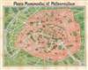
Paris Monumental et Métropolitain.
Iconic map of Paris and its monuments.
Choose a Collection:
- Digital Map Information
- Suitable for large format printing
- Full resolution TIFF file
- ICC color profile embedded
- Delivered instantly via download link
This Item
Enquire
Iconic map of Paris and its monuments.
This extremely appealing c. 1920 pocket map of Paris France by Robelin combines the virtues of a map and a view. Designed with the tourist in mind, this map covers the embastilled center of Paris and its immediate vicinity. It reflects the transformation and modernization of Paris under Napoleon III and Georges-Eugène Haussmann. Paris proper is colored in appealing pastels and exhibits more 'map-like' qualities in the layout of the streets, trains, and bridges. Various monuments, including the Eiffel Tower, the Arc de Triomphe, Sacre-Coeur, the Pantheon, and others are shown in profile. Major streets, subway lines, and subway stations are also noted. Paris is surrounded in green, including the Bois de Boulogne and the Bois de Vincennes. Several of the surrounding villages are labeled as well.Paris et ses Environs
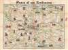
There is a second map on the verso, entitled Paris et ses Environs, which shows Paris and the surrounding area. This map shows the area around Paris from Beauvais, Compiegne, and Soissons to the north of Paris, to Chartres, Melun, and Provins to the south. This map also includes monuments in profile, such as the Chateau de Chantilly, the Chateau de Versailles, the Cathedral at Chartres, and the Chateau de Fontainebleau.Publication History
Though undated, we can assign an approximate date due to the development of the subway system and the map's overall style and construction. Accompanied by the original accompanying guide, featuring 12 pages of texts with guides to museums, libraries, and other points of interest in English and French. Prepared by Robelin.Condition
Very good. Exhibits light wear along original fold lines. Exhibits some light toning. Verso repairs to fold separations. Closed margin tears professionally repaired on verso. Map with monuments of the environs of Paris on verso.