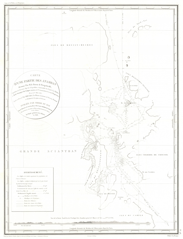
1837 Tardieu Map of Siantan Island, Anambas Islands Regency, Riau Archipelago, Indonesia
PartieAnambas-tardieu-1837
Title
1837 (dated) 24.5 x 18.75 in (62.23 x 47.625 cm)
Description
A Closer Look
Siantan Island occupies the lower left. The Port de Clermont-Tonnerre and the Canal de Clermont-Tonnerre separate Siantan Island from the 'Ile de Bougainville,' which must be Bajau Island. Parts of the coastline of the 'Ile de Bougainville' are ghosted in, underscoring the lack of exploration. Several other islands appear above and to the right of Siantan Island, including the 'Ile de la Thétis' named after Bougainville's flagship. The routes of the Thétis and the Espérance fill the channels between the islands and anchors mark locations where the two ships anchored during their exploration of the archipelago.The Voyage Around the World by Hyacinthe de Bougainville
Hyacinthe Yves Philippe Florentin de Bougainville (December 26, 1781 - October 18, 1846) was a French admiral and the son of the famous navigator Louis-Antoine de Bougainville who successfully completed the first French circumnavigation. The younger Bougainville began his circumnavigation from Brest, France, when he left on March 2, 1824, and returned to Brest on June 23, 1826. Bougainville commanded the frigate Thétis and the corvette Espérance. The French government gave Bougainville secret orders to scout British strongholds throughout the Pacific. The voyage made numerous stops over the 27-month voyage, calling at Pondicherry, Manila, Macau, Singapore, Surabaya, Madura, Port Jackson (Sydney), Hobart, Valparaiso, and Rio de Janeiro. This expedition was the first European expedition to explore and map the Anambas Islands, and it was among the first French expeditions to visit Singapore.The Anambas Islands
The Anambas Islands (officially the Anambas Islands Regency) is a small archipelago in Indonesia. The archipelago is situated in the North Natuna Sea, east of Malaysia and west of Borneo. Today, it is administratively a regency of the Riau Islands Province and is home to just over 47,000 people, according to the 2020 Census.Publication History and Census
This map was engraved by Ambroise Tardieu after work done by Edmond Bigot de la Touanne during Bougainville's voyage with the lettering engraved by J. P. Besançon. It was published in 1837 in the atlas that accompanied Bougainville's Journal de la Navigations Autour du Globe de la Frégate la Thétis et de la Corvette l'Espérance Pendant les années 1824, 1825 et 1826. We note two cataloged examples of the separate map, which are part of the collections at the Bayerische Staatsbibliothek and the National Library of Australia.CartographerS
Ambroise Tardieu (March 2, 1788 - January 17, 1841) was a prominent French cartographer and engraver operating in the late 18th and early 19th centuries. He was member of the large and prolific Tardieu family, which, for over 200 years, produced multiple skilled and active engravers. Tardieu's work is known for its beauty and accuracy as well as for its depth of detail. Tardieu's most important work is his version of John Arrowsmith's large format map of the United States, published in 1806. Ambroise Tardieu is eclipsed in fame by his son, artist and medical scholar, August Ambroise Tardieu. Ambroise Tardieu is also frequently confused with Jean Baptiste Pierre Tardieu, another unrelated French map and print engraver active in the early 19th century. More by this mapmaker...
Jacques-Marie Hacq (September 22, 1785 – 18??) was a French letter and line engraver, and historian, active in Paris during the middle part of the 19th century. Hacq was born in Paris and trained under J. P. Besançon, who he succeeded at the Dépôt de la Guerre in 1830. He engraved for the Dépôt de la Guerre as early as 1830 and for the Dépôt des Cartes et Plans de la Marine from, at least, 1840 to 1852. In addition to his work for the French Government, he also completed maps and engravings for Lesage, Lapie, Dufour, Duperrez, Gouvion St. Cyr, and Dumont d'Urville. His historical works include a history of the Napoleonic Wars and a history of Paris under the reign of Louis XIII. During most of his career in Paris he lived at 58 Rue de la Harpe. Learn More...
Edmond Bigot de la Touanne (May 3, 1796 - October 27, 1863) was a French topographical artist and naval officer. La Touanne served as a lieutenant on Hyacinthe de Bougainville's voyage around the world in 1824 - 1826. The French government had given Bougainville secret orders to scout the defenses of British settlements in the South Seas. Thus, while they were in Port Jackson, La Touanne, Bougainville, and other expedition members extensively explored the colony, and La Touanne created a detailed map of Port Jackson. In 1828, La Touanne published a folio of 35 lithographic views relating to the voyage entitled Album Pittoresque de la Frégate La Thétis et de la Corvette l'Espérance. In 1837, when Bougainville's Journal of the expedition was published, all 56 of its lithographed plates, views, and maps were done after La Touanne's work. Learn More...

