This item has been sold, but you can get on the Waitlist to be notified if another example becomes available, or purchase a digital scan.
1749 Vaugondy Map of Texas and California
PartieMexique-vaugondy-1749$175.00

Title
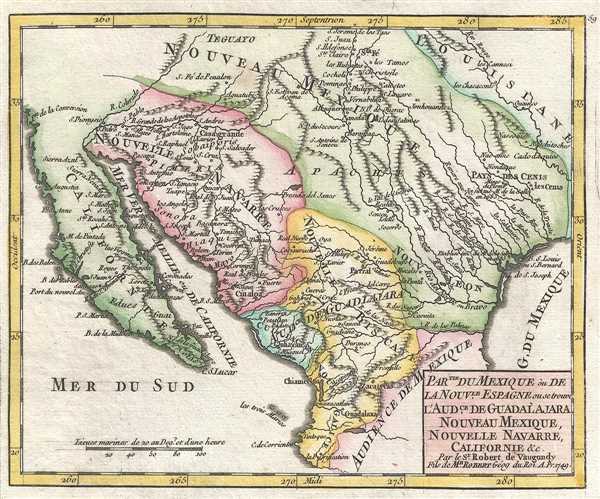
Partie du Mexique ou de la Nouvelle Espagne ou se trouve l'Audience de Guadalajara, Nouveau Mexique, Nouvelle Navarre, Californie, etc. Par le Sr. Robert de Vaugondy, Fils de Mr. Robert Géog du Roi.
1749 (dated) 6.75 x 8 in (17.145 x 20.32 cm) 1 : 14400000
1749 (dated) 6.75 x 8 in (17.145 x 20.32 cm) 1 : 14400000
Description
This is a hand colored 1749 Didier Robert de Vaugondy map of Mexico and Texas. Issued on the cusp of the French and Indian War, this map depicts the southwestern United States from Santa Fe south to central Mexico and from California to Oklahoma (Louisiana) and the Red River in French Louisiana. Although still Spanish Territory, the lands that would become Texas, not here labeled as such, are already somewhat segregated, north of the Palmas River, from the territories to the south. The map depicts Spanish territory in Central and North America, labeling a very large portion of the current southwestern United States, including Texas, as New Mexico, with other regions called New Navarre, the Audience of Guadalajara, and the Audience of Mexico. At this point in history, these Spanish territories were bordered by French Louisiana, as depicted on the map. Numerous rivers are depicted, including the Colorado, the Rio Bravo, and the Red River. Myriad cities are depicted as well.
Of some interest, the land of Teguayo is prominently identified at the norther extremis of the map. Teguayo is one of several mythical 'kingdoms of gold' believed to exist in the largely unexplored American Southwest. It was popularized by the nefarious Don Diego Dionisio de Peñalosa. Peñalosa could generously described as a roguish adventurer but is more accurately a traitorous scoundrel in the true conquistador fashion. In a power grab, Peñalosa latched on to legends of Teguayo referenced in the 1630 Benavides Memorial. He elaborated the Franciscan missionary Alonso de Benavides' description of the mythic city turning it into a metropolis to rival the former Aztec capital of Tenochtitlan. When the Spanish refused to fund his plan to conquer the Teguayo, he turned to the French, who were entrenched in nearby Louisiana. While the French did not fund Peñalosa, the inclusion of a prominent Teguayo on this map, as well as notes regarding La Salle's claims well inside Spanish territory, suggest French interest in expanding their claims in America – an ambition that would soon lead to the French and Indian War.
This map was published by Gilles Robert de Vaugondy in his Atlas Universel, Portatif et Militaire in the 1749 edition.
Cartographer
Robert de Vaugondy (fl. c. 1716 - 1786) was French may publishing from run by brothers Gilles (1688 - 1766) and Didier (c. 1723 - 1786) Robert de Vaugondy. They were map publishers, engravers, and cartographers active in Paris during the mid-18th century. The father and son team were the inheritors to the important Nicolas Sanson (1600 - 1667) cartographic firm whose stock supplied much of their initial material. Graduating from Sanson's maps, Gilles, and more particularly Didier, began to produce their own substantial corpus. The Vaugondys were well-respected for the detail and accuracy of their maps, for which they capitalized on the resources of 18th-century Paris to compile the most accurate and fantasy-free maps possible. The Vaugondys compiled each map based on their own geographic knowledge, scholarly research, journals of contemporary explorers and missionaries, and direct astronomical observation. Moreover, unlike many cartographers of this period, they took pains to reference their sources. Nevertheless, even in 18th-century Paris, geographical knowledge was limited - especially regarding those unexplored portions of the world, including the poles, the Pacific Northwest of America, and the interiors of Africa, Australia, and South America. In these areas, the Vaugondys, like their rivals De L'Isle and Buache, must be considered speculative or positivist geographers. Speculative geography was a genre of mapmaking that evolved in Europe, particularly Paris, in the middle to late 18th century. Cartographers in this genre would fill in unknown lands with theories based on their knowledge of cartography, personal geographical theories, and often dubious primary source material gathered by explorers. This approach, which attempted to use the known to validate the unknown, naturally engendered rivalries. Vaugondy's feuds with other cartographers, most specifically Phillipe Buache, resulted in numerous conflicting papers presented before the Academie des Sciences, of which both were members. The era of speculative cartography effectively ended with the late 18th-century explorations of Captain Cook, Jean Francois de Galaup de La Perouse, and George Vancouver. After Didier died, his maps were acquired by Jean-Baptiste Fortin, who in 1787 sold them to Charles-François Delamarche (1740 - 1817). While Delamarche prospered from the Vaugondy maps, he defrauded Vaugondy's window Marie Louise Rosalie Dangy of her rightful inheritance and may even have killed her. More by this mapmaker...
Source
Robert de Vaugondy, G., Atlas Portatif, Universel, et Militaire, (Paris: Vaugondy, Durand, Pissot) 1749.
Condition
Very good. Blank on verso. Original press mark visible.
References
Pedley, M. S., Bel et Utile, p. 216, 482.