1798 Laurie and Whittle Nautical Chart or Map of Burma (Myanmar)
PeguBurma-lauriewhittle-1798-2$2,000.00


Title
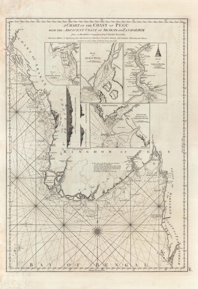
A Chart of the Coast of Pegu with the Adjacent Coast of Arakan and Tanasserim.
1798 (dated) 32 x 23 in (81.28 x 58.42 cm) 1 : 1250000
1798 (dated) 32 x 23 in (81.28 x 58.42 cm) 1 : 1250000
Description
A fine example of Laurie and Whittle's 1798 nautical chart or map of Burma (Myanmar), or as it was known in the 18th century, Pegu. It reflects the rapid increase in trade relations with and geographical knowledge of Southeast Asia in Europe in the preceding decades.
Countless depth soundings, notes on the sea floor, commentary on reefs, rhumb lines, hazards, and other practical information are included in detail for the mariner. The interior is predominantly blank, and annotations clearly refer to a general lack of information regarding the region. Nonetheless, the 1748 site of an English factory on the Persain River (now rendered as Pathein) is identified and various inland river routes are tenuously ghosted in.
Though dated 1798, the chart appeared as Plate 36 in Laurie and Whittle's The country trade East-India pilot for the navigation of the East Indies and Oriental Seas… published in 1799, a scarce printing of Laurie and Whittle's work more commonly titled The oriental navigator : or, new directions for sailing to and from the East Indies… (where it appeared as an unnumbered plate). The chart is only independently cataloged among the holdings of the National Library of Australia and is scarce to the market.
A Closer Look
Coverage ranges from the city of Arakan, south along the coastline to the Irrawaddy River Delta, inland to Rangoon (Yangon, here identified as Dagon, for the Shwedagon Pagoda), and then south past the Gulf of Martaban (Mawlamyine), to the Kyan River and Tavay Point (formerly Victoria Point, currently Kawthaung, on the Thailand-Myanmar border).Countless depth soundings, notes on the sea floor, commentary on reefs, rhumb lines, hazards, and other practical information are included in detail for the mariner. The interior is predominantly blank, and annotations clearly refer to a general lack of information regarding the region. Nonetheless, the 1748 site of an English factory on the Persain River (now rendered as Pathein) is identified and various inland river routes are tenuously ghosted in.
The Insets
Four large inset maps occupy the country's interior. These include a plan of the Martaban River (modern Mawlamyine) and the sacred Buddhist shrine at Quekmay (Kyaiktiyo), precariously balanced atop the 'Golden Rock.' Another map illustrates the Arakan River entrance, though it does not continue inland as far as the city of Arakan, today's Mrauk-U. A third plan details the Sirian River, the modern Irrawaddy River, identifying the site of Rangoon (Yangon) as Dagon. Finally the fourth inset focuses on the entrance to the Perseen River, an important trade artery. To the left of the inset maps, there are three coastal profile views.Publication History and Census
This chart is cartographically derived from Jean-Baptiste d'Apres de Mannevillette's similar chart issued for the 1745 Neptune Oriental. It was twice reissued by Sayer and Bennet, and again, in this updated version, by Laurie and Whittle, who acquired the Sayer and Bennet printing plates. The present Laurie and Whittle example from 1798 is notable for several important updates by the British sea captains Hayter, Ritchie, and Newland, and (aside from the publication date) can be distinguished from Laurie and Whittle's 1794 chart of the same by the inclusion of the coastal profiles to the left of the inset maps.Though dated 1798, the chart appeared as Plate 36 in Laurie and Whittle's The country trade East-India pilot for the navigation of the East Indies and Oriental Seas… published in 1799, a scarce printing of Laurie and Whittle's work more commonly titled The oriental navigator : or, new directions for sailing to and from the East Indies… (where it appeared as an unnumbered plate). The chart is only independently cataloged among the holdings of the National Library of Australia and is scarce to the market.
Cartographer
Laurie and Whittle (fl. 1794 - 1858) were London, England, based map and atlas publishers active in the late 18th and early 19th century. Generally considered to be the successors to the Robert Sayer firm, Laurie and Whittle was founded by Robert Laurie (c. 1755 - 1836) and James Whittle (1757-1818). Robert Laurie was a skilled mezzotint engraver and is known to have worked with Robert Sayer on numerous projects. James Whittle was a well-known London socialite and print seller whose Fleet Street shop was a popular haunt for intellectual luminaries. The partnership began taking over the general management of Sayer's firm around 1787; however, they did not alter the Sayer imprint until after Sayer's death in 1794. Apparently Laurie did most of the work in managing the firm and hence his name appeared first in the "Laurie and Whittle" imprint. Together Laurie and Whittle published numerous maps and atlases, often bringing in other important cartographers of the day, including Kitchin, Faden, Jefferys and others to update and modify their existing Sayer plates. Robert Laurie retired in 1812, leaving the day to day management of the firm to his son, Richard Holmes Laurie (1777 - 1858). Under R. H. Laurie and James Whittle, the firm renamed itself "Whittle and Laurie". Whittle himself died six years later in 1818, and thereafter the firm continued under the imprint of "R. H. Laurie". After R. H. Laurie's death the publishing house and its printing stock came under control of Alexander George Findlay, who had long been associated with Laurie and Whittle. Since, Laurie and Whittle has passed through numerous permeations, with part of the firm still extant as an English publisher of maritime or nautical charts, 'Imray, Laurie, Norie and Wilson Ltd.' The firm remains the oldest surviving chart publisher in Europe. More by this mapmaker...
Condition
Very good. Uneven toning and offsetting. Wear and creases in the margins and along edge.
References
OCLC 504600075.