
This item below is out of stock, but another example (left) is available. To view the available item, click "Details."
Details
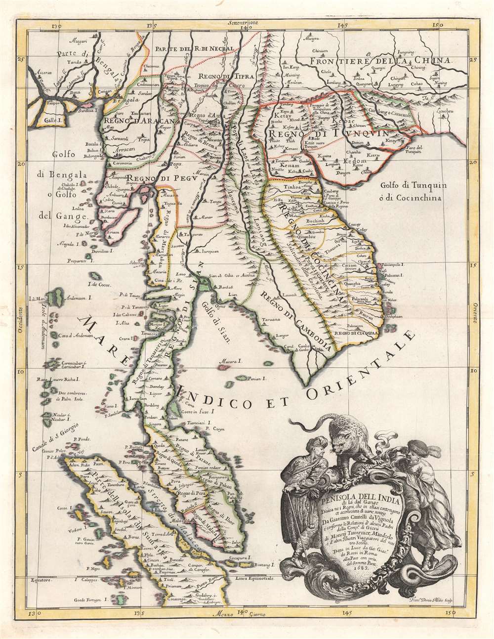
1683 Cantelli da Vignola Map of Southeast Asia: Malay, Singapore, Thailand
$2,000.00
1683 Cantelli da Vignola Map of Southeast Asia: Malay, Singapore, Thailand
PenisoladellIndia-cantellidavignola-1683$900.00

Title
Penisola Dell India di la dal Gange Diusa ne i Regni, che in essasi contengono et accresciuta di varie notizie. Da Giacomo Cantelli da Vignola e conforme le Relationi di alcuni Padri della Compa di Giesu di Monsu Tavernier, Mandeslo e d`altri Illustri Viaggiatori del nostro Secolo . . . 1683.
1683 (dated) 21.5 x 16.75 in (54.61 x 42.545 cm) 1 : 6150000
1683 (dated) 21.5 x 16.75 in (54.61 x 42.545 cm) 1 : 6150000
Description
A rare, highly decorative, and cartographically significant 1683 map of Southeast Asia by Giacomo Cantelli da Vignola and Giacomo de Rossi. This is one of the first maps of Southeast Asia to incorporate independent polities in Malay based on new information from Johan Albrecht de Mandelslo (1616 - 1644) and Jean-Baptiste Tavernier (1605 - 1689). Centered on modern-day Bangkok, which is noted, this stunning map includes most of modern-day Thailand, all of Malaysia, Laos, Cambodia, Vietnam, and Singapore, and parts of Burma, China, and Sumatra. Bangkok is noted, although when this map was published, it had not yet risen to prominence. Conversely so too is the city of Aracan, which, when this map was issued, was at its height of nearly 160,000 people. Today it is better known as the remote and crumbling ruin of Mrauk U. A large and dramatic cartouche demands attention in the lower right and features two Southeast Asian potentates in postures of aristocratic savoir-faire. The shield itself is surmounted by an impressive snarling leopard.
Cartographic History
Cartographically this map is based upon earlier Dutch maps updated and revised with new information from the travels of Jesuit priests, the German adventurer Johan Albrecht de Mandelslo, and the French merchant Jean-Baptiste Tavernier – it is these last two individuals to whom the map is dedicated. Much of this new information is encapsulated by the first European cartographic depiction of political divisions in the Malay peninsula. The conventions established here by Cantelli da Vignola were subsequently followed by Coronelli and others. The next map to update these conventions with practical information was François Valentijn's 1725 Neue Karte von der Insel Sumatra issued nearly 40 years later.Publication History and Census
This map was prepared by Giacomo Cantelli da Vignola, engraved by Francus Donia Messis, and published by Giacomo de Rossi in his c. 1683 Mercurio Geografico. We note four examples cataloged in OCLC which are part of the collections at Harvard University, the Biblioteca Nacional de España, the Bibliothèque nationale de France, and the National Library of Australia.CartographerS
Giacomo Cantelli da Vignola (February 22, 1643 - November 30, 1695) was an important Italian cartographer and engraver active in 17th century Italy. Cantelli was born in Montorsello, near Vignola, Italy to a prominent local family. After studying literature at the University of Bologna, Cantelli took a position as secretary to the Marquis Obizzi de Ferrara. Eventually Cantelli relocated to Venice where he developed an interest in cartography. He later traveled to Paris in the company of the French ambassador where became acquainted with the French cartographer Guillaume Sanson, as well as his contemporaries Jacques-Andre Duval and Michel-Antoin Baudrand. It was most likely the influence of these innovative French cartographers that inspired Cantelli's careful and meticulous approach, in which he based his cartography not just on earlier maps, but also very much in the French style upon accounts written by travelers and merchants regarding actual travel to foreign lands. Back in Italy, Cantelli took service with Count Rinieri Marescotti, with whom he traveled extensively throughout Italy, becoming in the process acquainted with the Italian publisher Giovanni Giacomo de Rossi. It is with Rossi that Cantelli began officially publishing his maps. The earliest maps to bear the Cantelli-Rossi imprint date to 1672 and detail the Holy Land, Persia, and the Ottoman Empire. Around 1680 the duo also began to publish the Mercurio Geografico, a large format atlas illustrating all parts of the world in a splendid Italian baroque detail defined by elaborate finely engraved cartouche work, high quality paper, bold Roman lettering, and dark rich inks. Some have compared his style go that of Giovanni Antonio Magini, another Italian cartographer of the previous generation. Cantelli da Vignola in fact pioneered the Italian style of fine bold engraving that would eventually be embraced and expanded upon by Vincenzo Coronelli. His work drew the attention of Pope Innocent XI and Reggio Francesco II d'Este, the Duke of Modena, both of whom offered him a position as court geographer. Cantelli chose to work with the Duke of Modena, in the service of whom he produced numerous maps and well as two large globes. He died in Modena in November 1695. More by this mapmaker...
Giovanni Giacomo de Rossi (1627 - 1691) was an Italian engraver and printer, active in Rome during the second half of the 17th century. His father, Giuseppe de Rossi (1570 - 1639), was the founder of the most important and active printing press of the 17th century in Rome. The printing press was begun in 1633, by Giuseppe de Rossi, and it passed firstly to Giovanni Giacomo and to his brother Giandomenico (1619 - 1653), and then later to Lorenzo Filippo (1682-?), then Domenico de Rossi (1659 - 1730). Giovanni Giacomo de Rossi was most active between 1638 and 1691 and was to take the company to the height of its success. The artists that he printed the etchings for included Giovanni Benedetto Castiglione (1609 - 1665), Pietro Testa (1612-1650), and Giovan Francesco Grimaldi (1606 – 1680). Cartographically he is best known for producing the maps of Giacomo Cantelli da Vignola and publishing them in his c. 1683 Mercurio Geografico. In 1738 the firm became the Calcografia Camerale, from 1870 until 1945 the Regia Calcografica, and today it is known as the Calcografia Nazionale. The Calcografia Nazionale holds is one of the finest collections of early printing plates and prints in the world. Learn More...
Source
Rossi, G., Mercurio geografico overo guida geographica in tutte le partie del Modo, (Rome) 1683.
Condition
Very good. Minor expert wormhole repairs to outer margins. Original platemark.
References
Shirley, R., Maps in the atlases of the British Library, T.ROSS-1e, #180. OCLC 495092971, 224328437. Durand, F., Maps of Malaya and Borneo: Discovery, Statehood and Progress, p. 112, plate no 37. Suárz, T., Early Mapping of Southeast Asia, p. 212-213.