This item has been sold, but you can get on the Waitlist to be notified if another example becomes available, or purchase a digital scan.
1642 Blaeu Map of Persia (Iran)
Persia-blaeu-1634$300.00

Title
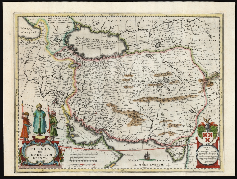
Persia Sive Sophorum Regnum.
1634 (undated) 15 x 19.5 in (38.1 x 49.53 cm) 1 : 9400000
1634 (undated) 15 x 19.5 in (38.1 x 49.53 cm) 1 : 9400000
Description
This is a classic 17th-century Willem Blaeu map of the Kingdom of Persia - one of the most beautiful Dutch Golden Age maps of Persia.
A Closer Look
The map is centered on the Persian Empire under the Safavid dynasty, extending eastwards to the Indus River, beyond which the Mogol empire held sway. To the west, the Fertile Crescent and Arabia are shown as part of the Ottoman Turkish Empire. The Caspian Sea is shown in the fat, ovoid form first appearing in the geography of Claudius Ptolemy. This model was not replaced until the end of the 17th century, and the Caspian Sea was not correctly depicted on a map until the 1720s. The southernmost extent of the Grand Duchy of Muscovy can be seen in the Caucasus, northwest of the Caspian. The lands west of the Volga are dominated by Tartaria: the empire of the Great Khan. The map is drawn on a long-lived geographical model, only slightly changed since the mid-16th century. Though Blaeu's map would prove influential and widely-copied, it was itself based on precursor maps by Hondius and Ortelius - and theirs found their detail primarily in that of Giacomo Gastaldi's 1559 Il Disegno Della Prima Party Del Asia. Gastaldi's seminal map captured Persia during the first century of the Safavid Dynasty (1501 - 1736). Happily for the mapmakers that followed, the same dynasty remained in power until 1736 and thus arguably the Flemish and Dutch successors to Gastaldi's map were at the very least no less obsolete.Richly Decorative
While spare in decoration - the Indian Ocean features a single ship - it is nevertheless a beautiful engraving. The mountains of central and eastern Persia are shown pictorially. The region's inland seas and lakes are distinctively stippled and shaded. The garlanded title cartouche is surmounted by three figures: most likely represents Shah Abbas the Great (1571 - 1629) flanked by two guards. In the lower right, Blaeu has included an elegant dedicatory cartouche displaying the name and family arms of Amsterdam politician Theodoro Tholing, which marks this example as a first state. Tholing had proved a poor choice as a patron: he went bankrupt in 1644 and fled Amsterdam. The second, 1644 state of this map sports an empty dedicatory cartouche; by 1662 Joan Blaeu picked a solvent dedicatee in Simon Van Hoorn, and dedicated the final, third state of the map to him. (Alai notes that this is the only one of Blaeu's maps to incorporate such a change of patron.Publication History and Census
This map was engraved for inclusion in the 1634 edition of Blaeu's atlas, and with the abovementioned changes to the dedication, remained in the Blaeu oeuvre until the burning of the firm in 1672. The present example is the first state of the map (with the dedication to Tholing). Itc orresponds typographically to the 1642 Dutch edition of Blaeu's Toonneel des Aerdrycx oft Nieuwe Atlas. In its many editions, it is well represented in institutional collections.Cartographer
Jan Jansson or Johannes Janssonius (1588 - 1664) was born in Arnhem, Holland. He was the son of a printer and bookseller and in 1612 married into the cartographically prominent Hondius family. Following his marriage he moved to Amsterdam where he worked as a book publisher. It was not until 1616 that Jansson produced his first maps, most of which were heavily influenced by Blaeu. In the mid 1630s Jansson partnered with his brother-in-law, Henricus Hondius, to produce his important work, the eleven volume Atlas Major. About this time, Jansson's name also begins to appear on Hondius reissues of notable Mercator/Hondius atlases. Jansson's last major work was his issue of the 1646 full edition of Jansson's English Country Maps. Following Jansson's death in 1664 the company was taken over by Jansson's brother-in-law Johannes Waesberger. Waesberger adopted the name of Jansonius and published a new Atlas Contractus in two volumes with Jansson's other son-in-law Elizée Weyerstraet with the imprint 'Joannis Janssonii haeredes' in 1666. These maps also refer to the firm of Janssonius-Waesbergius. The name of Moses Pitt, an English map publisher, was added to the Janssonius-Waesbergius imprint for maps printed in England for use in Pitt's English Atlas. More by this mapmaker...
Source
Blaeu, W. / Blaeu, J. / Blaeu, C., Toonneel des Aerdrycx oft Nieuwe Atlas, (Amsterdam: Blaeu) 1642.
The classic Dutch atlas, whose publication ushered in the Dutch golden age of cartography. Willem Jansz Blaeu had been, since 1604, producing engraved maps for sale; these were separate issues (and all consequently extremely rare) until the publishing of Blaeu's Appendix in 1630 and 1631, which also included a number of maps purchased from the widow of Jodocus Hondius, (for example his famous iteration of John Smith's map of Virginia.) In 1634, he announced his intention to produce a new world atlas in two volumes, entitled Theatrum Orbis Terrarum, sive Atlas Novus (Théâtre du Monde ou Nouvel Atlas) (in an effort to invoke the successful work of the same title produced by Ortelius the previous century, while reinforcing the notion of it being a new work.) This work was published first in German in 1634, followed by Latin, Dutch and French editions in 1635. Blaeu's maps have always been noted for the quality of their paper, engraving and fine coloring, and this was the intent from the very start. The 1634 announcement of the upcoming work described it: 'All editions on very fine paper, completely renewed with newly engraved copperplates and new, comprehensive descriptions.' (van der Krogt, p,43) Many of the most beautiful and desirable maps available to the modern collector were printed and bound in Blaeu's atlases. Willem's son, Joan, would go on to add further volumes to the Atlas Novus, concurrently printing new editions of the first two volumes with additional maps, in effect making these new editions an entirely new book. Under Joan there would be nine Latin editions, twelve French, at least seven Dutch, and two German. This exceedingly successful work would be the mainstay of the Blaeu firm until 1661, at which point the work was supplanted by Joan Blaeu's masterwork Atlas Maior in 1662.
Condition
Excellent. A few creases, else a beautiful, full-margined example with attractive hand color.
References
OCLC 158732678. Rumsey 10017.616 (1665, third state.) Van der Krogt, P. C. J., Koeman's Atlantes Neerlandici, (Vol. 2) 8200:2.1. Alai, C., General Maps of Persia 1477-1925, #E 83.