This item has been sold, but you can get on the Waitlist to be notified if another example becomes available.
1966 Admiralty Nautical Chart or Maritime Map of the Western Persian Gulf
PersianGulfWesternSheet-admiralty-1966$375.00


Title
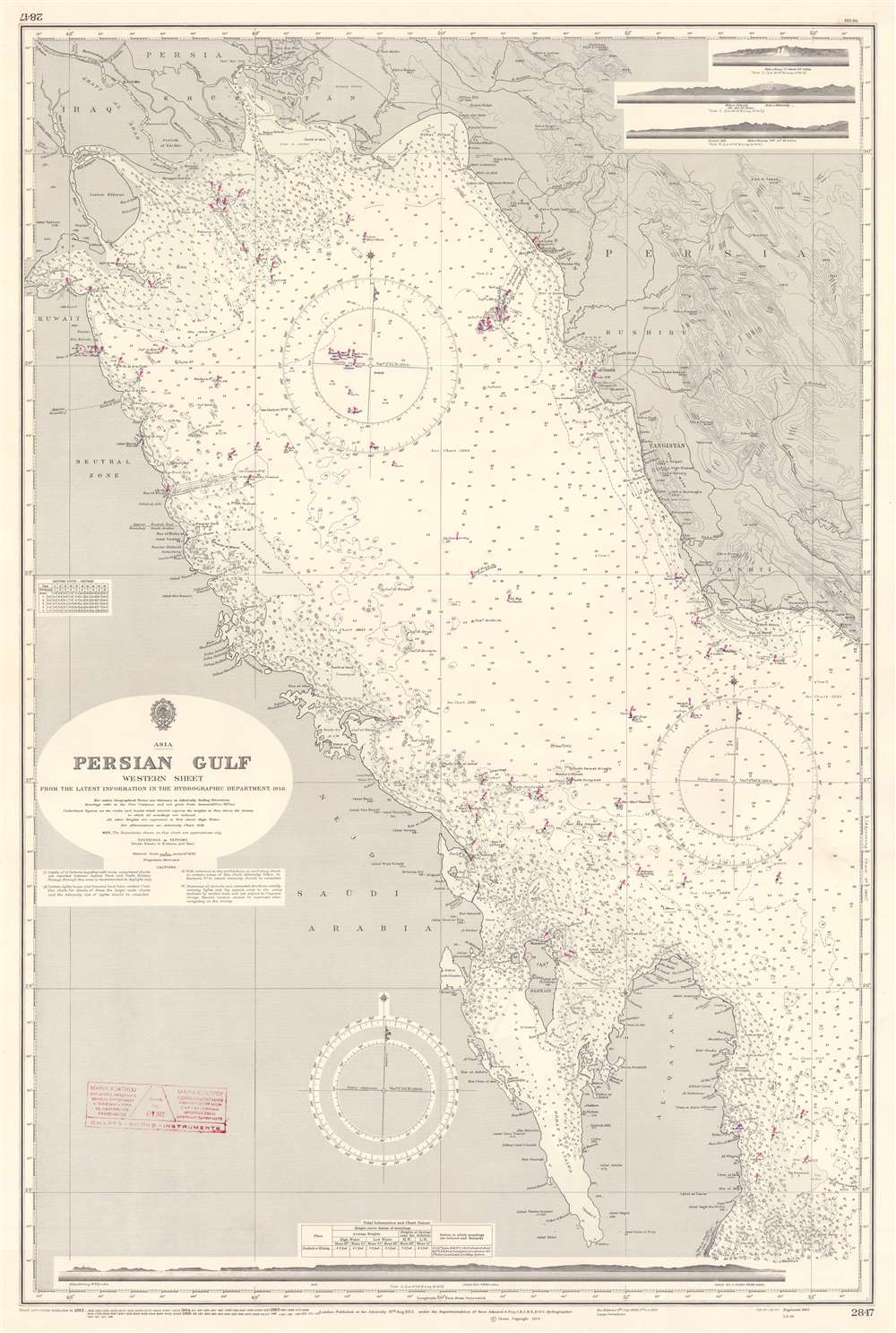
Persian Gulf Western Sheet.
1966 (dated) 40 x 26.5 in (101.6 x 67.31 cm) 1 : 750000
1966 (dated) 40 x 26.5 in (101.6 x 67.31 cm) 1 : 750000
Description
This is a 1966 British Admiralty nautical chart or maritime map of the western Persian Gulf. Coverage extends from Kuwait Bay to Qatar. This map details the early development of the Persian Gulf oil industry.
The Question of Oil
Gulf countries provide nearly half of the world's crude oil. Millions of barrels pass through the Strait of Hormuz daily. Innumerable depth soundings provide navigation aids to these critically important ships, along with notations marking flats and shoals. The terminus of an oil pipeline from Saudi Arabia is illustrated and labeled in the left side of the Gulf just to the right of the words 'Neutral Zone'. Purple cones highlight lights marking navigation hazards.The Saudi Arabian - Kuwaiti Neutral Zone
The British established the Saudi Arabian - Kuwaiti neutral zone in 1922 when measuring the border between the two countries. Saudi Arabia and Kuwait agreed to mutually administer this region of around two thousand square miles to accommodate nomadic Bedouin inhabitants. The two countries consented to come to a more definitive settlement at a later date. Neither Saudi Arabia nor Kuwait prioritized finalizing a more permanent solution until the late 1930s, when oil was discovered in southeastern Kuwait, near the Zone. Further discoveries within the Neutral Zone followed in 1958. They continued to mutually administer the region until an agreement formally dividing ownership was signed on July 7, 1965, that took effect on July 25, 1966 - the year this map was issued.Publication History and Census
This chart was created and published by the British Admiralty in 1966. No examples of the present edition are cataloged in OCLC but examples of two earlier editions appear. The present example bears stamps from the original chart seller in Piraeus, Greece, a major port near Athens.Cartographer
The British Admiralty Office (1795 - Present) or the United Kingdom Hydrographic Office refers to the Branch of the English government that is responsible for the command of the British Navy. In 1795 King George III created the United Kingdom Hydrographic Office, known in short as the U.K.H.O., to provide top notch nautical charts to the vast Royal Navy. Prior the founding of the Admiralty the surveying and creation of nautical charts was primarily a commercial venture wherein the cartographer himself, more of than not, actually financed the printing of his own material. The great navigator Cook himself is known to have scrambled for funds to publish his own seminal charts - the most important and advanced of the period. The system of privately funded nautical mapping and publishing left vast portions of the world uncharted and many excellent charts unpublished. King George III, responding significant loss in trade revenue related to shipwrecks and delay due to poor charts, recognized the need for an institutionalized government sponsored cartographic agency - the Admiralty. The first head of the Admiralty, a position known as Hydrographer, was the important cartographer Alexander Dalrymple. Dalrymple started by organizing and cataloging obtainable charts before initiating the laborious process of updating them and filling in the blanks. The first official Admiralty Chart appeared in 1800 and detailed Quiberon Bay in Brittany. By 1808 the position of Hydrographer fell to Captain Thomas Hurd. Hurd advocated the sale of Admiralty charts to the general public and, by the time he retired in 1829, had issued and published some 736 charts. Stewardship of the organization then passed to Rear Admiral Sir Francis Beaufort. It was under Beaufort's administration that the Admiralty truly developed as a "chart making" as opposed to a "chart cataloging" institution. Beaufort held his post from 1829 to 1854. In his 25 years at the Admiralty Beaufort created nearly 1500 new charts and sponsored countless surveying and scientific expeditions - including the 1831 to 1836 voyage of the H.M.S. Beagle. By 1855 the Admiralty's chart catalog listed some 1,981 charts. More by this mapmaker...
Condition
Very good. Exhibits wear along original centerfold. Stamp from seller present on both recto and verso.