1935 Survey of India Map of Peshawar, Pakistan
PeshawarGuide-surveyofindia-1935$2,500.00

Title
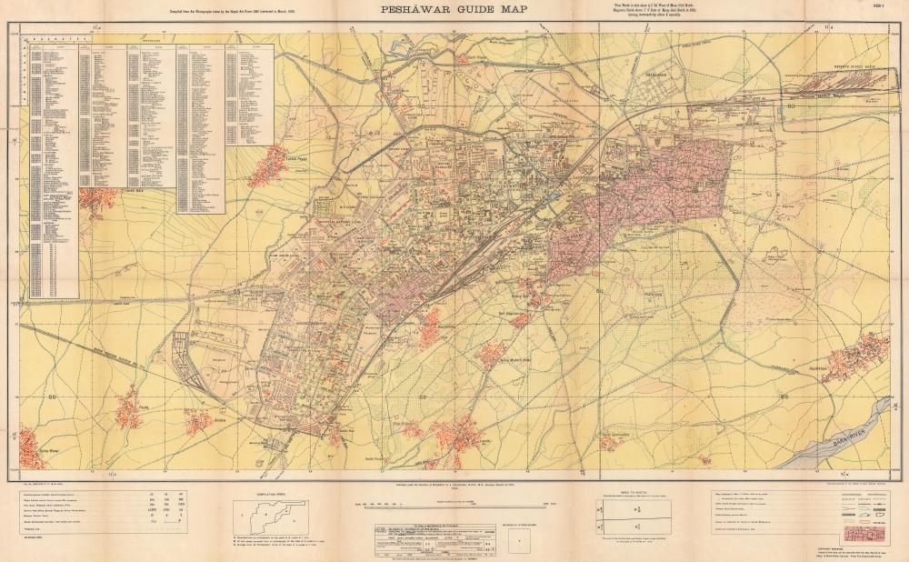
Peshāwar Guide Map.
1935 (dated) 26.25 x 42.25 in (66.675 x 107.315 cm) 1 : 10560
1935 (dated) 26.25 x 42.25 in (66.675 x 107.315 cm) 1 : 10560
Description
An intriguing and evocative piece, this is a 1935 first-edition Survey of India map of Peshawar, Pakistan. This is likely the earliest scientific survey of Peshawar, following the 1927 Survey of India map of Peshawar City - which did not include the Cantonment. The map was issued during the Second Mohmand Campaign, a major British offensive out of Peshawar against the Pashtun Mohmand hill tribes of the Khyber Pass.
Historical Context
Hoping to maintain their independence, the Mohmand Pashtun plagued the British in Peshawar and vicinity from 1850 onwards. From their outposts in the mountains, they raided British-aligned developments, road work, railroad lines, and trade caravans. There were multiple punitive campaigns against the Mohmand tribes, with fortifications and territories in the Khyber Pass passing back and forth over decades. The final campaign, in 1935 - when this map was issued - saw overwhelming force, including the first use of tanks, deployed against Mohmand, forcing them to finally sue for peace.A Closer Look
The map depicts Peshawar and its immediate vicinity. The contrast between the sprawling but organized British Cantonment, the heart of regional British power, and the ancient Pashtun city is noteworthy. The Cantonment is surrounded in barbed wire, walls, and other fortifications, occupying more ground than the city proper - a sober underscoring of regional instability and strategic significance, described by one British officer in 1900 'within a day's ride of our most important garrison, Peshawar, is an absolute terra incognita and there is absolutely no security for British life a mile or two beyond our border.' Military hospitals, headquarters buildings, barracks, other army housing, churches, clubs, and mess halls, among other buildings, are labeled within the cantonment. The entire cantonment lies across the North Western Railway's main line, with the cantonment on the left and Peshawar city on the right. Within Peshawar itself, schools, roads, the clock tower, and Fort Bāla Hisar are identified. There is alphabetical index of locations within the cantonment and Peshawar in upper left. It identifies railway stations, bazars, roads, barracks, cinemas, and post and telegraph offices, along with dozens of other locations.Peshawar and British India
In 1849, following the Second Anglo-Sikh War (1848 - 1849), the British East India Company annexed the Sikh Empire and from that territory created Punjab Province, which encompassed from Delhi to the Afghan border. In 1901, with the Great Game winding down, the British Raj broke off a North-West Frontier Province out of Punjab, setting Peshawar as its provincial capital. With a strategic situation roughly 30 miles from the Khyber Pass, the city emerged as a commercial hub and defensive bastion between India and Central Asia. The Peshawar Cantonment was thus continuously expanded throughout the second half of the 19th century and early 20th century. Part of this project was the construction, largely via coercive labor practices, of the North Western State Railway.The North Western State Railway
The North Western State Railway was formed in 1886, shortly after the Second Anglo-Afghan War (1878 - 1880) as a means to quickly transport troops to the Afghan border. The NWSR was a consolidation of the Scinde, Punjab and Delhi Railway, the Indus Valley State Railway, the Punjab Northern State Railway, the eastern section of the Sind-Sagar Railway, the southern section of the Sind-Pishin State Railway, and the Kandahar State Railway. It became one of the major rail arteries of British India. After the 1947 Partition, most of the railway became part of Pakistan's national railway network.Publication History and Census
This map was created and published by the Survey of India in 1935 and heliozincographed at the Survey offices in Calcutta. This is the only known surviving example of the 1935 first edition. A handful of 1946 editions are cataloged in institutional collections in the United States, Britain, and Australia.CartographerS
Survey of India (1767 - Present) is India's central engineering agency in charge of mapping and surveying the country. It was founded in 1767 by Major James Rennell, who took the post of first Surveyor General, with the mission to map and consolidate the territories of the British East India Company. The Survey undertook the Great Trigonometrical Survey between 1802 and 1852 in an attempt to accurately measure the Indian Subcontinent - considered one of the greatest feats of mapping of all time. It also sponsored clandestine surveys, at times disguised as Buddhist pilgrims, to infiltrate and map Tibet, then a closed country. With India's independence in 1947, the Survey was folded into the new Indian government, which it remains part of to this day. More by this mapmaker...
Harold John Couchman (July 29, 1882 - November 30, 1956) was a British surveyor and soldier who became Surveyor of India. Born in Haileybury, he attended school in Haileybury before entering the Royal Military Academy. Commissioned in the Royal Engineers in August 1900, Couchman was transferred to India in 1902. In 1906 he became part of the geodetic branch of the Survey of India. Initially assigned to assist with fieldwork, by the 1908-09 field season Couchman oversaw operations in southwest India. In 1910-11 he took part in the regional gravity surveys of Burma and then in 1912-14 in southern and central India. He was transferred to the headquarters office of the Survey of India in the spring of 1914. During World War I, he served in France and Belgium from September 1915 until November 1918. In 1919 he returned to the Survey of India and spent the rest of his career with the Survey, except for three years (1926 - 1929) when he served as deputy master, security printing. Over the course of these years, he served as director in Shillong, Simla, and Calcutta, and, in 1933, was appointed Surveyor General. He held that position until he retired in 1937. He rose to the rank of brigadier in 1933 and was knighted in 1937. He married Evelyn Beatrice in 1925 and they had no children. Learn More...
Condition
Average. Two tears extending 5 inches into printed area from top margin repaired on verso. Verso repairs at fold intersections. Small areas of loss at fold intersections. Closed margin tears repaired on verso.
References
Lanzillo, A., 'Building Peshawar: Labor, Security, and Infrastructure at the Edge of Empire', Journal of Social History (Vol. 56, No. 3 Spring 2023) pp. 532-558. Accessed June 5, 2023.