
1897 Stanford Map of Northern Pakistan and eastern Afghanistan: Peshawar

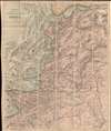

Stanford's Sketch Map of The North-Western Frontier of India.
Afridi revolt in the Kyber.
- Digital Map Information
- Suitable for large format printing
- File Size: 41.73 MB
- File Type: ZIP / TIFF
- ICC color profile embedded
- Delivered instantly via download link
Afridi revolt in the Kyber.
A remarkable 1887 map of northwestern Pakistan and northeastern Afghanistan produced at the height of the Great Game to satisfy British interest in the Tirah Campaign. Centered on Peshawar, the map covers modern-day Khyber Pakhtunkhwa (Khyber Pass), from Fayzabad (Faizabad), Afghanistan, to Jhelum, Pakistan, and parts of Punjab.Tirah Campaign
This map was a kind of early newsmap issued to satisfy British interest in the Tirah Campaign, or Tirah Expedition. The Tirah Expedition (September 1897 - April 1898) was fought between the Punjab Army Corps, led by General Sir William Lockhart, and the Pashtun Afridi (افریدی) tribe over control of the Khyber Pass and Tirah Valley. The suppressive campaign followed a rebellion of the Afridi, who were charged with defending British interests in the Kyber Pass. Afridi rebels seized several forts on the Samana Range near the city of Peshawar. Lockhart retaliated with an organized campaign leveraging superior British training, armament, and resources. The Afridi generally avoided direct conflict, instead relying on guerrilla attacks, but over the course of several months, suffered severe losses and lost all of the Khyber forts. Rather than face another campaign in the Spring, the Afridi surrendered their territory and arms to the British. This map must have been issued early in the campaign, shortly after the September 1897 rebellion.The Great Game
'The Great Game' was a diplomatic confrontation between the British and Russian Empires over Afghanistan and other territories in Central and Southern Asia. The conflict, rooted in long-standing animosity between Russia and Britain, revolved around Afghanistan, which, while lacking significant resources of its own, was strategically situated. For its part, Russia feared that Britain was making commercial and military inroads into Central Asia, an area long within the sphere of influence of St. Petersburg. Britain, conversely, feared that Russia was making gains in India, 'the jewel in the crown' of British Asia. The escalating tensions led to several wars and proxy wars: The First Anglo-Afghan War (1839 - 1842), the First Anglo-Sikh War (1845 - 1846), the Second Anglo-Sikh War (1848 - 1849), and the Second Anglo-Afghan War (1878 - 1880), along with the Russian annexations of Khiva, Bukhara, and Kokand. Then as now, Afghanistan proved a grinding stone upon which the world's great empires diminished themselves, none achieving a definitive victory despite committing staggering resources. The Great Game 'ended' on September 10, 1895, with the signing of the Pamir Boundary Commission Protocols, which stabilized the border between Afghanistan and the Russian Empire - but well into the 20th century, the British were well aware the conflict remained. Regarding the attitude of Afghans to the British and to the Russians, the general assumption of the British was that 'Some will fight for us, some against us, but all will fight.'Publication History and Census
This map was issued by Stanford's Geographical Establishment in 1887. We note examples at the University of Minnesota and at the Bibliothèque nationale de France. Scarce to the market.Cartographer
Edward Stanford (May 27, 1827 - November 3, 1904) was one of the most prolific map publishing firms of the late 19th century. The company began as a partnership in 1848 between the 21 year old Edward Stanford and the established map dealer Trelawney Saunders. By 1853 the partnership had dissolved and Edward Stanford took full control of the business. A subsequent series of expansions and exciting new map issues finally led to the production of Stanford's masterwork, "Stanford's Library Map of London". This map is still available and remains somewhat accurate. At the time of publishing it was hailed by the Royal Geographical Society as "the most perfect map of London that has ever been issued". In 1882 Edward Stanford Sr. passed the firm on to his son, Edward Stanford Jr. who continued in his father's proud tradition. Today the Stanford firm still publishes maps and remains one of the most important and prolific cartographic publishers in the world. Further Details...
Condition
Very good. Folds into original red linen binder.
References
University of Minnesota Libraries, John R. Borchert Map Library, G7693.P8 1897. Bibliothèque nationale de France, département Cartes et plans, GE C-2460.