
This item below is out of stock, but another example (left) is available. To view the available item, click "Details."
Details
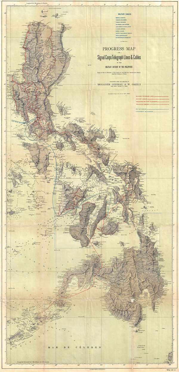
1900 Greely Map of the Philippines and Military Telegraph Lines and Cables
1900 (dated) $900.00
1900 Greely Map of the Philippines showing Telegraph Lines
Philippines-greely-1900$450.00

Title
Progress Map of Signal Corps Telegraph Lines and Cables in the Military Division of the Philippines.
1900 (dated) 42.5 x 20.5 in (107.95 x 52.07 cm) 1 : 900000
1900 (dated) 42.5 x 20.5 in (107.95 x 52.07 cm) 1 : 900000
Description
This is a scarce 1900 map of the Philippines prepared under the direction of General Adolphus Washington Greely. When this map was issued, Greely was the chief of the U.S. Army Signal Corps, in charge of constructing telegraph cables throughout U.S. Territories. In the Philippines, units under Greely's command laid over 10,000 miles of telegraph cable. Combined with existing British submarine lines, the telegraph cables laid under Greely's tenure provided the first comprehensive communication network throughout the Philippines Islands. This map represents a major step forward in Philippine infrastructure.
The map is large and comprehensive, extending from the Babuyan Islands to the Sulu Archipelago, encompassing most of the modern day Philippines with the exception of Palawan. Cartographically it is derived from the 1870 work of Claudio Montero y Gay. The map exhibits limited depth soundings throughout, but particularly between major island groups. American telegraphic cables, both extent and projected, are highlighted in red, while British lines appear in blue.
This map is uncommon on the market. It was printed in Washington D.C. by the A. B. Graham Photo Lithography Corporation.
Cartographer
Andrew B. Graham (1845 - September 9, 1909) was an American lithographer active in Washington, D.C. in late 19th and early 20th century. Graham was born in Washington D.C., the son of a lithographer and engraver. After college, he joined the U.S. Coast Survey, where he was a draftsman until 1889. He retired from the Coast Survey to take over management of his father's lithography firm. The firm, Andrew B. Graham Company, was one of several that thrived on lucrative government publication contracts. Graham died of 'brain fever' in his Washington D. C. residence on September 9 of 1909. Some of his work was republished posthumously until about 1917, and his firm was active until at least the early 1920s. More by this mapmaker...
Condition
Good. Professionally flattened and laid on archival tissue. Some wear and soiling along original fold lines. Even overall toning.
References
OCLC 35065162.