1785 Zatta Map of the Philippines
Philippines-zatta-1785$1,800.00

Title
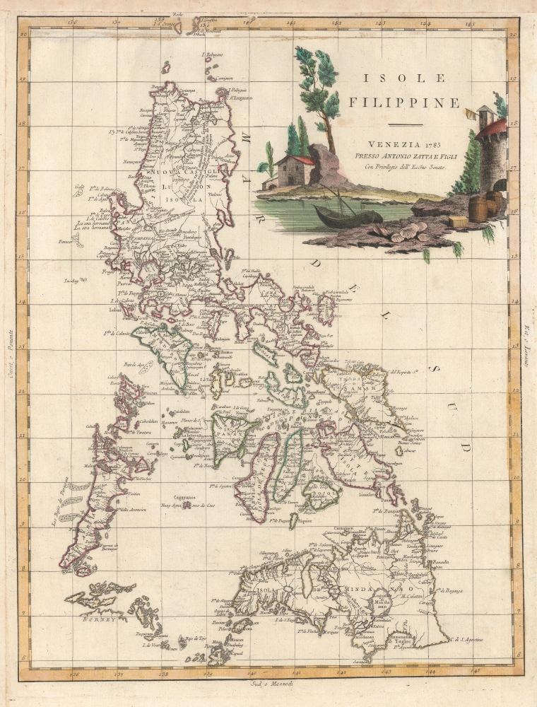
Isole Filippine.
1785 (dated) 16 x 12.25 in (40.64 x 31.115 cm) 1 : 4200000
1785 (dated) 16 x 12.25 in (40.64 x 31.115 cm) 1 : 4200000
Description
This is Antonio Zatta's elegant 1785 representation of the Philippine archipelago. It is based on the 1734 map of Pedro Murillo Velarde, S. J., considered the most important map in the history of the Philippines.
Waterways, settlements, and administrative divisions (outlined in hand color) appear on land, while hazards and sand banks are marked out at sea. Notes throughout provide brief information on local indigenous peoples, history, means of travel, and more, such as the comment about St. Francis Xavier's (purported though unconfirmed) visit to Mindanao. A vibrantly-colored cartouche at top-right depicts a seaside scene.
A Closer Look
Zatta hews closely to Velarde's map ('Carta Hydrographica y Chorographica de las Yslas Filipinas…'), the first scientific map of the Philippines. The archipelago's hundreds of islands and islets are displayed with impressive accuracy, though less so 'at the margins,' as in the southwest, including the partial northern coast of Borneo. Other islands are in the correct location but misshapen, such as Marinduque, below Luzon and east of Mindoro, while other oddities reveal the still partial understanding of the islands' interiors, such as a very oversized 'Laguna di Mindanao' (Buluan Lake) and an unnamed interior lake (likely Lake Wood) on Mindanao at bottom-right.Waterways, settlements, and administrative divisions (outlined in hand color) appear on land, while hazards and sand banks are marked out at sea. Notes throughout provide brief information on local indigenous peoples, history, means of travel, and more, such as the comment about St. Francis Xavier's (purported though unconfirmed) visit to Mindanao. A vibrantly-colored cartouche at top-right depicts a seaside scene.
Publication History and Census
This map was produced by Antionio Zatta 'and Sons' for his Atlante Novissimo. Perhaps a dozen examples of the atlas are cataloged in OCLC, while the map is independently cataloged by Cornell University and the University of British Columbia.Cartographer
Antonio Zatta (1775 - April 2, 1797) was the most prominent Italian map publisher of the late 18th and early 19th century. His firm, based in Venice, produced maps that mark an important transition from 18th to 19th century cartographic styles. He updates and redefines the traditional title cartouche by replacing the mythic elements common to the 17th and 18th century with more representative images. His maps also strive to keep many 18th century details, such as figural depictions on the map itself, while striving for the accuracy that a 19th century clientele demanded. His most important work is the four volume Atlante novissima published from 1775 to 1789. More by this mapmaker...
Source
Zatta A., Atlante Novissimo, (Venice) 1785.
Condition
Good. Soiling in margins and near border.
References
OCLC 606379747.