
This item below is out of stock, but another example (left) is available. To view the available item, click "Details."
Details
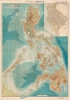
1944 Showa 19 Japanese Map of the Philippines during World War II
$2,400.00
1944 Showa 19 Japanese Map WWII of the Philippines (very large)
PhilippinesManila-kawamata-1944-2$475.00


Title
フィリピン詳密地圖 / Detailed Map of the Philippines. / Firipin shomitsu chizu.
1944 (dated) 42 x 28.5 in (106.68 x 72.39 cm) 1 : 1500000
1944 (dated) 42 x 28.5 in (106.68 x 72.39 cm) 1 : 1500000
Description
A rare 1944 Showa 19 Japanese large format map of the Philippines issued just 5 days after the WWII Philippines Campaign (1944 - 1945) began. The map is an expansion on a similar map issued for the 1942-3 'Greater East Asia Co-Prosperity Sphere' map series, which it stylistically resembles despite being four times the size. This map was issued to satisfy an increased Japanese need for information and reconnaissance following General Douglas MacArthur's landing at Leyte.
A Closer Look
Despite its stylistic similarity to the earlier map series, the present offering is a separate issue. The map features detailed topographic information throughout. It also employs shading to illustrate undersea depths. Most text is in Japanese, but some island names are identified in English, suggesting that the source for this map may have been British or American material. There is a large inset of Manila in the upper right quadrant.The Philippine Campaign
Launched on October 20, 1944, the Philippine Campaign was a World War II joint American and Filipino military operation intended to liberate the Philippine Islands from occupying Imperial Japanese forces. The Japanese Army overran most of the Philippines during the first half of 1942, retaining it for the following 2 years. American General Douglas MacArthur began the campaign by announcing on Philippine radio 'This is the Voice of Freedom, General MacArthur speaking. People of the Philippines: I have returned.' The campaign progressed rapidly, driving the Japanese out of one island after another. Although the Japanese were clearly losing the war by this time, they gave no sign of capitulation and refused to surrender. During the course of the campaign, Japan suffered nearly half a million casualties compared to only about 50,000 Americans. The campaign continued until Japanese forces in the Philippines were ordered to surrender by Tokyo on August 15, 1945, after the dropping of atomic bombs on Hiroshima and Nagasaki.Publication History and Census
This map was created by Teruya Kawamata (川俣鐵也) for the South East Secretariat of Greater East Asia Province (大東亜省南方事務局). It was printed in Tokyo on October 25, Showa 19 or 1944, and released 5 days later, on October 30, 1944. We have only been able to identify a single example in any institutional collection, in this case, at the National Diet Library, Tokyo.Condition
Good. Map exhibits some staining and discoloration. Wear on original fold lines. Minor verso reinforcement.
References
OCLC 935459611.