
1928 Harold H. Brown Pictorial Map of the Holy Land / Israel / Palestine w/ Sinai

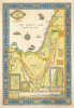

The Picture Map of the Holy Land.
Holy Land: From Exodus to the age of steam.
- Digital Map Information
- Suitable for large format printing
- Full resolution TIFF file
- ICC color profile embedded
- Delivered instantly via download link
Holy Land: From Exodus to the age of steam.
This is Harold Haven Brown's 1928 chromolithograph pictorial map of the Holy Land, combining biblical geography with illustrated cities, ancient trade routes, and modern railways. Coverage encompasses present-day Israel and the Palestinian territories, the Sinai Peninsula, and adjoining parts of Egypt, Jordan, Lebanon, and Syria. From the Israelites' wanderings to steamships navigating the Suez Canal ot the Hejaz Railway, Brown presents the region as a landscape of overlapping histories.Biblical Geography
Brown locates familiar biblical episodes throughout the map, including David's encounter with Goliath, Jonah's departure from Jaffa, John the Baptist's ministry, Aaron's death, and Esau's settlement. The route out of Egypt and the Israelites' subsequent wanderings are traced, with key events identified along the way. A vignette near the Egyptian border depicts Joseph, Mary, and the infant Jesus fleeing Herod.Explanatory panels summarize the geographical setting of Jesus's life and ministry and clarify the map's references to the Twelve Tribes of Israel. These annotations make the sheet both a decorative pictorial map and a guide to the places associated with biblical narratives.
Trade, Travel, and Historical Detail
Small views distinguish Jerusalem, Jericho, Damascus, Suez, and Cairo, while the Pyramids of Giza and the Great Sphinx appear nearby. Illustrated caravans follow ancient routes linking Egypt and Palestine and Cairo and Mecca. The Hejaz Railway between Damascus and Medina and the Kantara-Haifa Railway between Egypt and Palestine bring the scene into the modern era.Notes celebrate Phoenician seamanship, Tyre's dyes, glass, and metalwork, and the importance of Lebanese timber in ancient shipbuilding and construction. A Knights Templar shield evokes the Crusading period. Six vessel illustrations extend this historical range across the waterways: Egyptian, Phoenician, Roman, and Crusader ships, an Egyptian riverboat, and a modern steamship associated with the Suez Canal.
Insets and Decorative Border
Four insets add geographical context: a color-coded elevation map of Palestine, a plan of Jerusalem's Old City, a map of Jerusalem and its environs, and a profile showing the relative heights of important locations. The profile emphasizes the dramatic contrast between the Dead Sea, below sea level, and the heights of Mount Hermon.A decorative border of tile-like panels completes the composition, combining regional crops and vegetation with the traditional symbols of the four Evangelists: Matthew, Mark, Luke, and John.
Chromolithography
Chromolithography, sometimes called oleography, is a color lithographic technique developed in the mid-19th century. The process uses multiple lithographic stones, one for each color, to yield a rich composite effect. Generally, a chromolithograph begins with a black basecoat upon which subsequent colors are layered. Some chromolithographs used 30 or more separate lithographic stones to achieve the desired effect. Chromolithograph color can be blended for even more dramatic results. The process became extremely popular in the late 19th and early 20th centuries when it emerged as the dominant method of color printing. The vivid color chromolithography made it exceptionally effective for advertising and propaganda.Publication History and Census
The map was designed and drawn by Harold Haven Brown and published in New York by the R.R. Bowker Company in 1928. Institutional examples include the David Rumsey Map Collection at Stanford University and the International Pictorial Map Collection at St. Louis Public Library.Cartographers
Harold Haven Brown (June 6, 1869 - April 7, 1932) was an American artist, cartographer, illustrator, teacher, painter, and museum director. Born in Malden, Massachusetts, Brown attended the Massachusetts Normal Art School before heading to Paris, France, to study with Jean-Léon Gérôme at the École des Beaux-Arts and with J.P. Laurens at the Académie Julian. Brown also spent significant time studying museum work at the Louvre, the Musée de Cluny, and the Musée du Luxembourg. He married fellow artist Florence Bradshaw on November 4, 1897. The couple lived in Chicago and then Indianapolis, where Brown served as director of the John Heron Institute from 1913 to 1921. They then moved to Provincetown, Massachusetts, in 1923. Brown was a noted mapmaker and also created woodcuts and watercolors. He also wrote books and articles on calligraphy and on decorative, pictorial, and mechanical drawing. He and Florence played an important role in founding the Provincetown Art Association and Museum, and Brown served as its president from 1926 until he died in 1932. He and Florence had two children. Further Details...
The R.R. Bowker Company (1868 - present) is an American company currently based in New Providence, New Jersey that provides bibliographic information on published works to the books trade, including publishers, libraries, booksellers, and individuals. Bowker is also the exclusive U.S. agent for issuing International Standard Book Numbers (ISBNs). The company was founded in 1868 in New York City by Frederick Leypoldt, a bookseller, to provide and compile bibliographic information with the goal of making the book business more efficient. He established the Literary Bulletin, his first periodical, that year and in 1870 issued the first edition of his Annual American Catalogue, the forerunner of Books in Print. The first issue of Publisher's Weekly was published in 1872, with the first issue of Publishers' Uniform Trade-List Annual appearing in 1873, and followed by the first issue of Library Journal in 1876. The company was acquired by Richard Rogers Bowker in 1878. The pair then founded two influential book-industry references: Literary Marketplace and Ulrich's Periodicals Directory. The R.R. Bowker company was acquired by the Xerox Corporation in 1967, which then sold it to Reed International in 1985. Also in 1985, Publisher's Weekly was transferred to the Cahners Publishing Company after 113 years as part of the R.R. Bowker Company. The Cambridge Information Group bought Bowker in 2001, and sold Literary Marketplace in 2007. After the Cambridge Information Group acquired ProQuest Information and Learning, R.R. Bowker was position as an affiliate of ProQuest. Further Details...
Condition
Very good. A couple minor margin tears archivally closed on verso.
References
Rumsey 6863.000. OCLC 953572361.