This item has been sold, but you can get on the Waitlist to be notified if another example becomes available, or purchase a digital scan.
1790 Mondhare et Jean City Plan or Map of Paris, France
PlandeParis-mondharejean-1790$750.00


Title
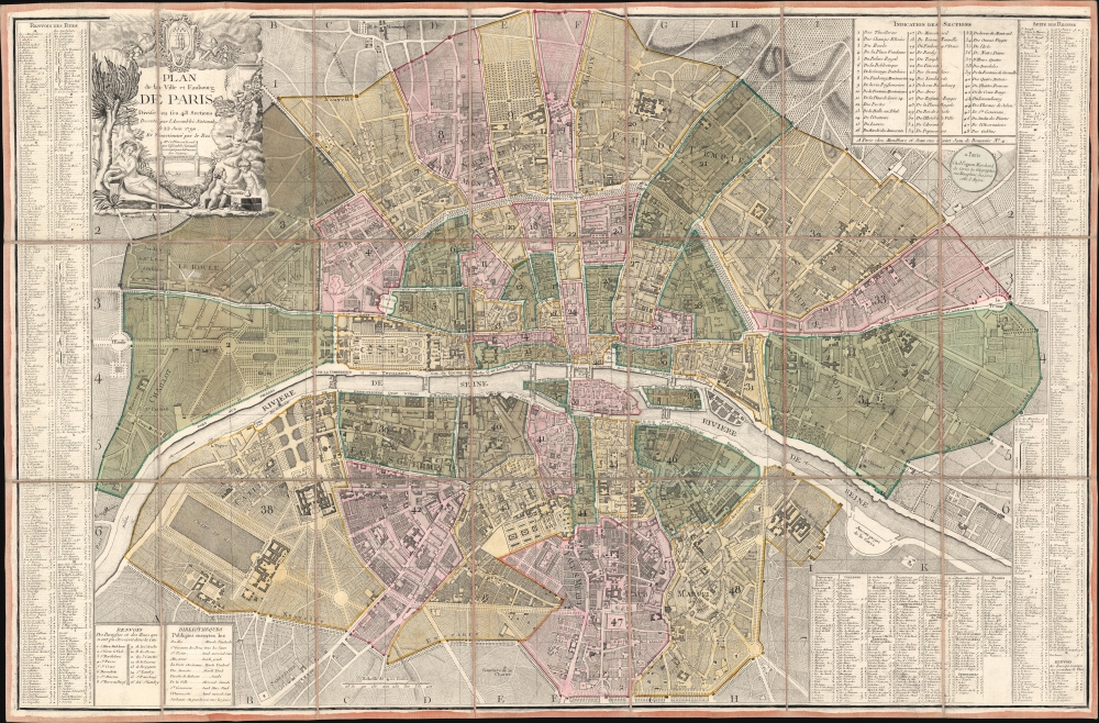
Plan de la Ville et Faubourg de Paris Divisé en ses 48 Sections Decreté par l'Assemblée Nationale le 22 Juin 1790 et Sanctionné par le Roi.
1790 (dated) 25.25 x 38.5 in (64.135 x 97.79 cm) 1 : 10000
1790 (dated) 25.25 x 38.5 in (64.135 x 97.79 cm) 1 : 10000
Description
A stunning 1790 Louis-Joseph Mondhare and Pierre Jean Revolutionary-Era city map of Paris, France - this is the only map the Assemblée Nationale recognized to delineate its newly created sections within Paris. The map was printed by order of the Assemblée Nationale a year the Storming of the Bastille and the outset of the French Revolution (1789 - 1799).
The Sections
Capturing a city in the throes of Revolution, the 48 new sections are numbered and shaded. The sections were established by the National Assembly as divisions for elections to the Estates-General. A civil committee, a revolutionary committee, and an armed force governed each and acted as intermediaries between the populace and the Paris Commune. The sections played an important role in the August 1792 election that directly led to the end of the monarchy in France. An index of the 48 sections appears in the upper right.A Closer Look
The map focuses on what today would be considered central Paris, stretching from the Place de l'Étoile to the Place du Trône (today's Place de la Nation). Apart from the sections, Paris's streets, monuments, and other buildings are illustrated. Among these are the Palais des Tuileries, the Louvre, the Place Vendome, the Madeleine, the Bastille, and Notre Dame. An alphabetic street index occupies both the left and right sides. Indexes of libraries, churches, hospitals, schools, parishes, and squares are included along the bottom border.Publication History and Census
This map was created and published by Louis-Joseph Mondhare and Pierre Jean in 1790. We note 7 examples cataloged in OCLC which are part of the collections at Princeton University, Harvard University, Cornell University, the University of Michigan, the University of Oregon, the Bibliothèque nationale de France, and the Universitätsbibliothek Kassel in Kassel, Germany.CartographerS
Louis-Joseph Mondhare (1734 - August 21, 1796) was a French engraver and publisher of maps, prints and vues d'optique active in the second half of the 18th century. Mondhare was born in Bougy (Calvados) and moved to Paris on or before 1759. He began publishing around 1760 under the Chez Mondhare imprint. On June 7 of 1784, his son-in-law Pierre Jean (1754-1829) joined the business and they changed their imprint to Mondhare & Jean. The Mondhare firm maintained their office in Paris on Rue St. Jacques, at the Hôtel Saumar, a well-known location for print sellers near St. Severin. Later they relocated to 32 Rue Saint-Jean de Beauvais. The firm ceased operation around 1796. Mondhare died shortly afterward in 1799. His name variantly appears on some imprints as Mondar or Mondhard. More by this mapmaker...
Pierre Jean (1754 - 1829) was a French engraver, publisher, print seller, and map maker active in Paris in the late 18th and early 19th centuries. Jean entered the engraving and printing business on June 7 of 1784 when he married the daughter of Louis-Joseph Mondhare, a prominent French engraver, print seller and map publisher. Mondhare changed the name of his firm to Mondhare & Jean. Under Mondhare, for about 12 years, Jean mastered the in-and-outs of the engraving and map publishing business. Mondhare retired in 1796, leaving Jean his business and printing plates. Jean subsequently continued to publish on his own account, as Chez Jean, from the old Mondhare & Jean offices at 32 Rue Saint-Jean de Beauvais. Learn More...
Condition
Excellent. Dissected into 21 panels and mounted on original linen.
References
Boutier, J., Les Plans de Paris, (Paris: Bibliothèque nationale de France) #350A. OCLC 64675110, 921704359.