This item has been sold, but you can get on the Waitlist to be notified if another example becomes available, or purchase a digital scan.
1752 Buache Map of the World on a Polar Projection (Arctic)
PlanispherePhysique-buache-1752$400.00

Title
Planisphere Physique où l'on voit du Pole Septentrional ce que l'on connoit de Terres et de Mers; Avec les Grandes Chaînes de Montagnes qui traversent le Globe.
1752 (dated) 13.5 x 13.5 in (34.29 x 34.29 cm) 1 : 60000000
1752 (dated) 13.5 x 13.5 in (34.29 x 34.29 cm) 1 : 60000000
Description
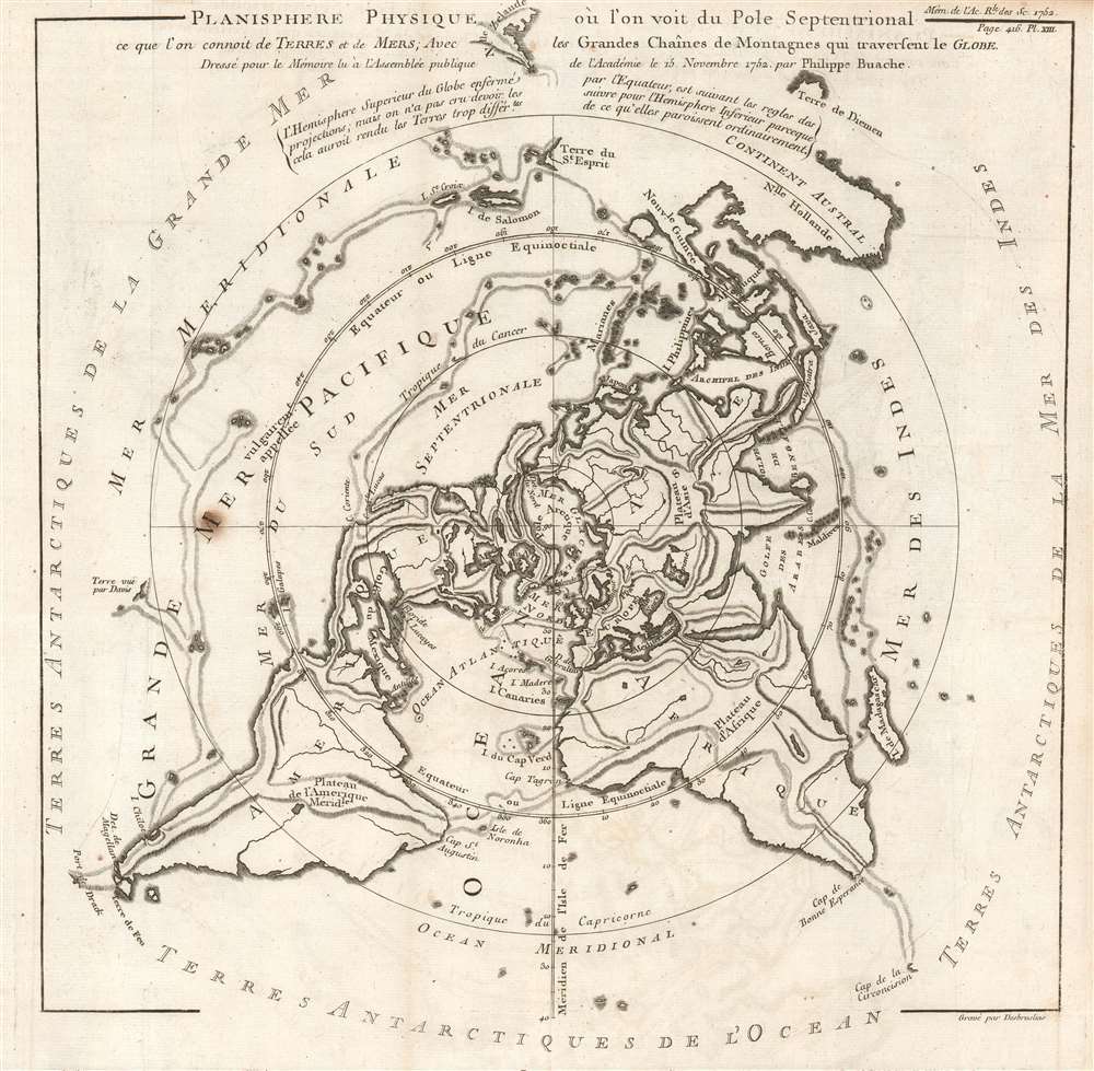
This is a beautiful 1752 Philippe Buache map of the world represented on an unusual polar projection rendered from the North Pole. The map covers from the North Pole Arctic region south beyond Tasmania (Van Diemen's Land) to include parts of New Zealand and even Cap de la Circoncision (Bouvet Island).
The Sea of the West was a common feature on many mid-18th century pre-Cook French maps. Its earliest appearance was likely on Jean-Baptiste Nolin's 1742 L'Amerique ou le Nouveau Continent; Nolin appears to have copied the relevant cartography from an unpublished manuscript globe by the great mapmaker, Guillaume De l'Isle. Then, starting in 1752, J. N. De l'Isle and Philip Buache began presenting the Sea of the West as a monumental bay in conjunction with a viable Northwest Passage. Though De l'Isle and Buache were immediately accused of fraud concerning this geographical feature, the Sea of the West appeared on many maps - some editions even post-dating Cook.
Buache's System of Geography
Buache published this map with a 1752 essay he presented to the Royal Academy of Sciences in Paris. This paper, Essai de Géographie Physique, argued that the Earth's great river basins are defined by major mountain ranges, many of which he believed extended beneath the oceans. The map's delineation of physical geography, both on the surface and below the sea, supports this theory and, true to form, Buache has added additional heretofore unknown mountain ranges where necessary to support his theory. Some of these include speculative mountainous regions in the northern Sahara, a mountain range bisecting central India, another along the Orinoco basin, and undersea mountain ranges connecting many Pacific islands. Buache believed that the 'blank spaces' on world maps could be mathematically deduced, making it unnecessary to wait for the era's great explorers to return from their world-spanning voyages with first-hand information. This innovative idea enthralled many Parisian intellectuals, and Buache was admitted into the Royal Academy of Sciences the same year this map and the associated essay were published.An Intriguing Map
The intriguing aspects of Buache's work are not limited to his innovative (if not entirely correct) geological theories. Additional elements of interest include various pre-Cook notions of world geography. Among these is an uncertain mapping of eastern Australia connecting it to New Guinea, and the mapping of some smaller Melanesian islands identified here as Terre du St. Espirit, which were, in fact, the New Hebrides mis-mapped by the near-insane 17th-century Portuguese navigator Pedro Fernandes de Queiros.The Sea of the West
Buache also includes a magnificent inland sea, called the Sea of the West or, in this case, the Mer de L'Ouest, in the northwestern part of America. This body of water, alternatively called the Sea of the West or Baye de l'Ouest, was speculated by Philippe Buache and Delisle in the early 18th century based upon wishful thinking, American Indian stories, and the somewhat questionable 16th-century explorations of Juan de Fuca. Here, Buache gives the Mer de l'Ouest its fullest expression. Curiously, he specifically does not connect it to either the factual network of lakes and rivers extending westward from the Hudson Bay or to the speculative De Fonte network just to the north.The Sea of the West was a common feature on many mid-18th century pre-Cook French maps. Its earliest appearance was likely on Jean-Baptiste Nolin's 1742 L'Amerique ou le Nouveau Continent; Nolin appears to have copied the relevant cartography from an unpublished manuscript globe by the great mapmaker, Guillaume De l'Isle. Then, starting in 1752, J. N. De l'Isle and Philip Buache began presenting the Sea of the West as a monumental bay in conjunction with a viable Northwest Passage. Though De l'Isle and Buache were immediately accused of fraud concerning this geographical feature, the Sea of the West appeared on many maps - some editions even post-dating Cook.
Publication History and Census
This map was created and published by Philippe Buache, engraved by Desbruslins, and published in 1752 with Buache's Essai de Géographie Physique. Two examples are cataloged in OCLC and are part of the institutional collections at the Bibliothèque nationale de France and the University of Texas at Arlington.CartographerS
Phillipe Buache (February 7, 1700 - January 24, 1773) was a late 18th century French cartographer and map publisher. Buache began his cartographic career as the workshop assistant and apprentice to the important and prolific cartographer Guillaume de L'Isle. Upon De L'Isle's untimely death, Buache took over the publishing firm cementing the relationship by marrying De L'Isle's daughter. Over the years, Bauche republished many of De L'Isle's maps and charts. Buache was eventually appointed Premier Geographe du Roi, a position created-for and previously held by Guillaume de L'Isle. Buache is most respected for his introduction of hachuring as a method from displaying underwater elevation on a two dimensional map surface. Buache compiled maps based upon geographic knowledge, scholarly research, the journals of contemporary explorers and missionaries, and direct astronomical observation. Nevertheless, even in 18th century Paris geographical knowledge was severely limited - especially regarding those unexplored portions of the world, including the poles, the Pacific northwest of America, and the interior of Africa and South America. In these areas the Buache, like his primary rival Robert de Vaugondy, must be considered a speculative geographer or 'positive geographer'. Speculative geography was a genre of mapmaking that evolved in Europe, particularly Paris, in the middle to late 18th century. Cartographers in this genre would fill in unknown areas on their maps with speculations based upon their vast knowledge of cartography, personal geographical theories, and often dubious primary source material gathered by explorers and navigators. This approach, which attempted to use the known to validate the unknown, naturally engendered many rivalries. Buache's feuds with other cartographers, most specifically Didier Robert De Vaugondy, resulted in numerous conflicting papers being presented before the Academie des Sciences, of which both were members. The era of speculatively cartography effectively ended with the late 18th century explorations of Captain Cook, Jean Francois de Galaup de La Perouse, and George Vancouver. Buache was succeeded by his nephew Jean-Nicholas Buache de Neuville. More by this mapmaker...
François Desbruslins (1709 - 17xx) was a French map and line engraver active in Paris during the mid-18th century, from approximately 1719 until 1757. His is known for architectural plans, maps, and scientific diagrams. He engraved numerous maps for several famous French cartographers, including Philippe Buache and Jacques-Nicolas Bellin. Learn More...
Condition
Very good. Light wear along original fold lines. Blank on verso.
References
OCLC 494524501.