This item has been sold, but you can get on the Waitlist to be notified if another example becomes available, or purchase a digital scan.
1670 Van Der Aa Map or Plan of Guangzhou, China
PlanKanton-vanderaa-1670$475.00

Title
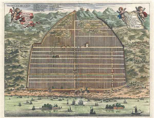
Kanton. In Platte Grondt. / Plate forme de la Ville de Kanton.
1670 (undated) 11.25 x 14.25 in (28.575 x 36.195 cm)
1670 (undated) 11.25 x 14.25 in (28.575 x 36.195 cm)
Description
This is a hand colored c. 1670 Pieter van der Aa map or plan of Guangzhou, formerly romanized as Canton, China. Depicted as a hybrid between a view and a plan, the Zhujiang River traverses the bottom of the map, and the amount of traffic and presumed commerce denotes Guangzhou's importance as a trading hub. People and boats are illustrated all along the riverbank, many in large groups. Behind the people, buildings are included, and then the city walls. The city walls are depicted in profile and encircle the city, which is depicted in a grid. Some of the buildings, the ones with the most importance, are depicted in detail and in profile. Beautiful scenery surrounds the city: tree covered hills and small villages in the valleys. Fifteen locations are identified by name and are labeled with letters. A table in French appears on the upper left, near the border, and one in Dutch appears on the right, being held aloft by two cherubs. A cherub holding a ribbon functions as the title cartouche in the upper-left corner.
Created during the final stages of the Qing conquest of the Ming, this view comes from a time of transition. The Qing were the last imperial dynasty in China, and was the second conquest dynasty to rule all of China. By 1670, the violence and civil war had only recently ended in southern China. The last of the people resisting the conquest of the Manchu's had moved south away from their advance, and Guangzhou is in southern China. Although fighting would continue until 1683, when Taiwan fell and became a part of the Qing Empire.
This beautiful work was produced during the reign of the Kangxi Emperor, which lasted 61 years, the longest of any Chinese emperor, produced by Pieter van der Aa from notes taken by Johan Nieuhof during his adventures in China. The view was published in Van der Aa's Galerie Agreable du Monde.
CartographerS
Pieter van der Aa (1659 - 1733) was a Dutch publisher of maps and atlases active in the late 17th and early 18th centuries. Van der Aa was born in Leyden in 1659. At nine he was apprenticed to a local bookseller and, by 21, had established his own publishing, printing, and auctioneering house. In 1692 Van der Aa was appointed to be one of the High Commissioners of the Booksellers Guild. During his long and impressive career Van der Aa produced thousands of maps, including a vast 28 volume atlas containing no less than 3,000 maps. Few of Van der Aa's maps were original productions, most being copied from the work of earlier cartographers. Nonetheless, when one of Van der Aa's rare original pieces does appear, his style, with unusual projections, elegant engraving, and precise detail, is instantly recognizable and highly desirable. He also pioneered the cartographic idea of separating border artwork from the map plate itself such that every map in a collection could have a similar elaborate border without actually having to re-engrave the complex plates. This technique was used to great effect by later 18th century publishers like Brion de la Tour. Following Van der Aa's death in 1733, his much admired Nouvel Atlas was reissued by the Dutch firm of Covens & Mortier. Today Van der Aa's work is admired for its fine delicate engraving and unusual projections and is considered highly desirable among collectors. More by this mapmaker...
Johan Nieuhof (1618 - 1672) was a traveler and explorer with the Dutch East India Company. Born in Uelsen, a small town in Lower Saxony near the Dutch-German border, Nieuhof spent most of his life in Brazil, China and India. He is most famous for his written account of his journey from Canton to Peking in 1655-1657 called An embassy from the East-India Company of the United Provinces, to the Grand Tartar Cham, Emperor of China. The book, which improved European knowledge about China, also severed as a major influence for the growth of Chinoiserie, making Niefuhof an influential Western writer on China. While stationed in Ceylon, he was imprisoned for trading illegally in pearls and later fired from the Dutch East India Company. After a short family visit in 1672, on his way back to the East Indies, he stopped in Madagascar and traveled inland to trade with the local tribes as well as secure water for the crew, but never returned. The captain, after waiting three days, assumed that Nieuhof and his company were killed. Later, a ship was sent from the Cape of Good Hope to retrieve the party, but found no trace of Nieuhof or his company. Learn More...
Source
Van Der Aa, P., Galerie Agreable du Monde, (Leiden) 1723.
Condition
Very good. Wear along original centerfold. Verso repairs to fold separations. Old repaired tear exptending one and a half inches into the printed area from the bottom margin.