This item has been sold, but you can get on the Waitlist to be notified if another example becomes available, or purchase a digital scan.
1827 Map of Paraguay and Northeastern Argentina
Plata-vandermaelen-1827$225.00

Title
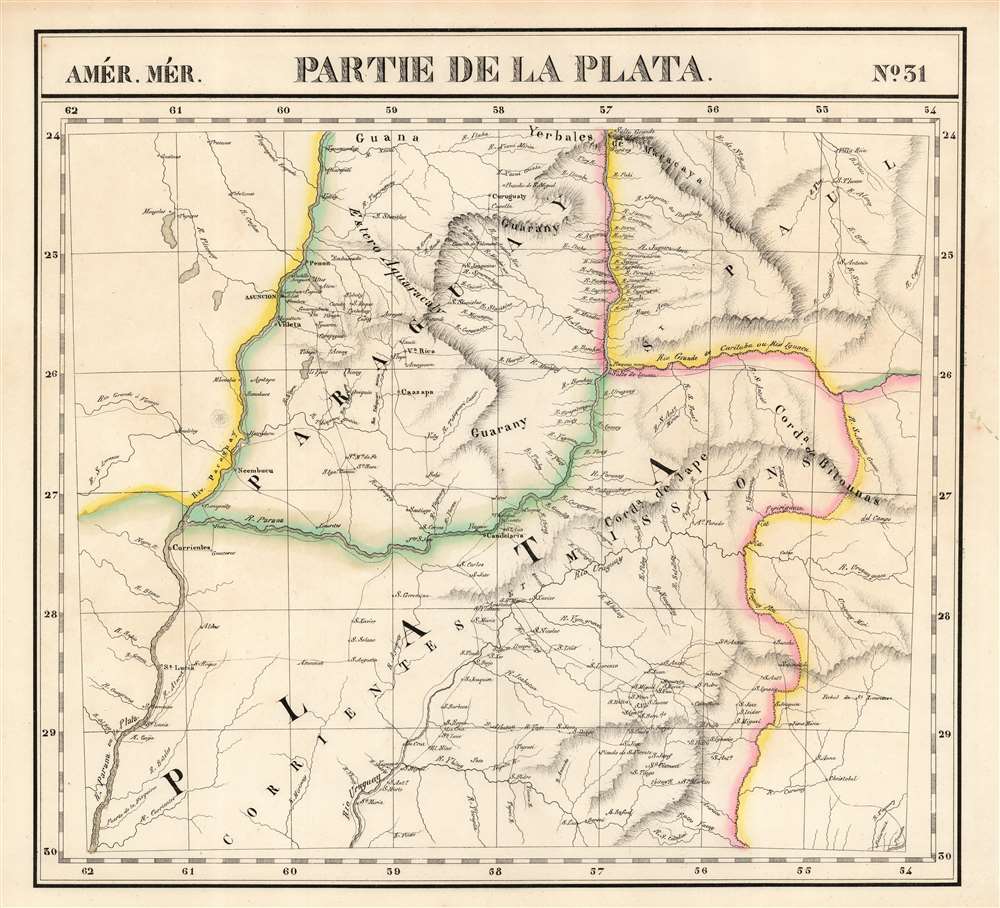
Partie de la Plata. Amer. Mér. no. 31.
1827 (undated) 19 x 20.5 in (48.26 x 52.07 cm) 1 : 1641836
1827 (undated) 19 x 20.5 in (48.26 x 52.07 cm) 1 : 1641836
Description
This is the rare 1827 Vandermaelen map of the northern extents of the rivers Paraguay, Parana, and Uruguay in South America. The map is centered on the region of the Misiones, a contentious frontier between the colonial powers in South America. It was produced after the 1814 annexation of the Misiones to Argentina's Corrientes, but in practice, neither Argentina nor any other country exerted de facto control, leaving the area to effectively govern itself. Three years after the printing of this map, the Argentine military took control of the region.
The area takes its name from the 17th century Jesuit establishment of missions among the native Guarani in this area, setting up a number of Jesuit Reductions and establishing as many as thirty mission villages. Along the three major rivers of the region, the map illustrates the settlements in detail. This was among the largest-scale maps of this region produced to date. Vandermaelen's Atlas, by applying a uniform scale to every map, afforded sharper detail to many remote areas of the world previously not so well depicted. This is also the first map of the region executed in lithograph.
The area takes its name from the 17th century Jesuit establishment of missions among the native Guarani in this area, setting up a number of Jesuit Reductions and establishing as many as thirty mission villages. Along the three major rivers of the region, the map illustrates the settlements in detail. This was among the largest-scale maps of this region produced to date. Vandermaelen's Atlas, by applying a uniform scale to every map, afforded sharper detail to many remote areas of the world previously not so well depicted. This is also the first map of the region executed in lithograph.
Publication History and Census
This map appeared in the fifth part, 'Cinquième partie, Amér. mérid.' of Vandermaelen's Atlas universel de géographie physique, politique, statistique et minéralogique. The atlas was produced in one edition in 1827. Only 810 complete sets were sold. The full set of six volumes appears in eleven institutional collections in OCLC. The 5th volume alone is listed in eleven. This map is listed as a separate only at the Clements Library.Cartographer
Philippe Marie Guillaume Vandermaelen (December 23, 1795 - May 29, 1869) was a Flemish cartographer active in Brussels during the first part of the 19th century. Vandermaelen is created with "one of the most remarkable developments of private enterprise in cartography," namely his remarkable six volume Atlas Universel de Geographie. Vandermaelen was born in Brussels in 1795 and trained as a globe maker. It was no doubt his training as a globe maker that led him see the need for an atlas rendered on a universal scale in order that all bodies could be understood in relation to one another. In addition to his great work Vandermaelen also produced a number of globes, lesser maps, a highly detailed 250 sheet map of Belgium, and several regional atlases. More by this mapmaker...
Source
Vandeermaelen, P., Atlas universel de geographie physique, politique, statistique et mineralogique, (Bruxelles: Vandermaelen) 1827.
Atlas Universel de Geographie. This great work, featuring some 378 unique maps and compiled over three years, was the first lithograph atlas, and the first to render the world on the same projection and at a uniform scale. It was no doubt Vandermaelen’s training a globe maker that led him see the need for an atlas rendered uniformly so that all bodies could be understood in relation to one another. As a result, many newly emerging areas received more attention than prior efforts. Maps of the American West, in particular, benefited: ‘no mapmaker had previously attempted to use such a large scale for any western American area.’ (Wheat). Central and South Asia also appear in sharper focus. Despite Vandermaelen’s reliance upon existing sources, his maps very frequently provided the clearest depictions available of many poorly-understood parts of the world. The atlas was an expensive production, costing $800 in 1827. Subscription lists indicate that only 810 full sets of the atlas were sold. It was printed on high-quality paper with superior hand coloring and was engraved in a clear, legible style. Conjoined, the maps of Vendermaelen's atlas would create a massive globe some 7.75 meters in diameter, a feat which was accomplished at the Etablissement Geographique de Brussels.
Condition
Excellent. Very faint toning at extremity of margins away from image, else fine with bright original wash color.
References
Rumsey 2212.310. OCLC 889736358.