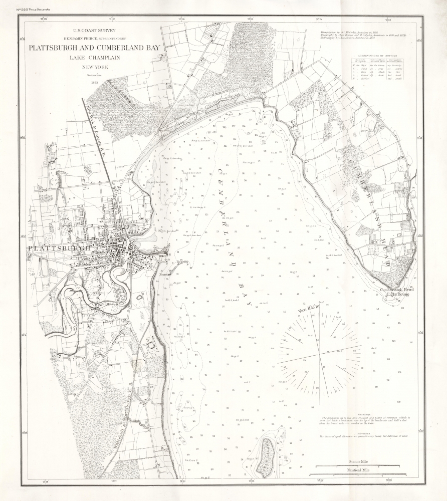
1873 U.S. Coast Survey Map of Plattsburgh and Lake Champlain, New York
PlattsburghCumberland-uscs-1873$1,000.00

Title
Plattsburgh and Cumberland Bay Lake Champlain New York.
1873 (dated) 23 x 20.5 in (58.42 x 52.07 cm) 1 : 16000
1873 (dated) 23 x 20.5 in (58.42 x 52.07 cm) 1 : 16000
Description
A rare 1873 U.S. Coast Survey nautical map of Plattsburgh and Cumberland Bay, Lake Champlain, New York. This example is printed on thick paper, suggesting intended use on a ship.
A Closer Look
Coverage includes the city of Plattsburgh as well as surrounding areas as far south as Crab Island and as far north and east as Cumberland Head. The course of the Saranac River, the Whitehall and Plattsburgh Railroad, and the New York and Canada Railroad (consolidated with the former the same year) stand out prominently. Exceptional inland detail is included, with important buildings, streets, and property lines indicated. In Lake Champlain, there are countless depth soundings as well as notes on reefs, shoals, beacons and lighthouses, and the composition of bottoms.Publication History and Census
This chart was produced by the U.S. Coast and Geodetic Survey in 1873. It is printed on heavy stock, intended for maritime use, rather than the more common thin, fragile paper used for charts in the annual Superintendent's Reports. An 1872 edition, unrecorded in institutional holdings, was previously sold by us. The present edition is only listed in the OCLC among the holdings of the Fenimore Art Museum and Yale University, with the latter being noted as derived from the Superintendent's Report.Cartographer
The Office of the Coast Survey (1807 - present) founded in 1807 by President Thomas Jefferson and Secretary of Commerce Albert Gallatin, is the oldest scientific organization in the U.S. Federal Government. Jefferson created the "Survey of the Coast," as it was then called, in response to a need for accurate navigational charts of the new nation's coasts and harbors. The spirit of the Coast Survey was defined by its first two superintendents. The first superintendent of the Coast Survey was Swiss immigrant and West Point mathematics professor Ferdinand Hassler. Under the direction of Hassler, from 1816 to 1843, the ideological and scientific foundations for the Coast Survey were established. These included using the most advanced techniques and most sophisticated equipment as well as an unstinting attention to detail. Hassler devised a labor intensive triangulation system whereby the entire coast was divided into a series of enormous triangles. These were in turn subdivided into smaller triangulation units that were then individually surveyed. Employing this exacting technique on such a massive scale had never before been attempted. Consequently, Hassler and the Coast Survey under him developed a reputation for uncompromising dedication to the principles of accuracy and excellence. Unfortunately, despite being a masterful surveyor, Hassler was abrasive and politically unpopular, twice losing congressional funding for the Coast Survey. Nonetheless, Hassler led the Coast Survey until his death in 1843, at which time Alexander Dallas Bache, a great-grandson of Benjamin Franklin, took the helm. Bache was fully dedicated to the principles established by Hassler, but proved more politically astute and successfully lobbied Congress to liberally fund the endeavor. Under the leadership of A. D. Bache, the Coast Survey completed its most important work. Moreover, during his long tenure with the Coast Survey, from 1843 to 1865, Bache was a steadfast advocate of American science and navigation and in fact founded the American Academy of Sciences. Bache was succeeded by Benjamin Pierce who ran the Survey from 1867 to 1874. Pierce was in turn succeeded by Carlile Pollock Patterson who was Superintendent from 1874 to 1881. In 1878, under Patterson's superintendence, the U.S. Coast Survey was reorganized as the U.S. Coast and Geodetic Survey (C & GS) to accommodate topographic as well as nautical surveys. Today the Coast Survey is part of the National Oceanic and Atmospheric Administration or NOAA as the National Geodetic Survey. More by this mapmaker...
Condition
Very good. Vertical discoloration at left and fold line visible at right.
References
OCLC 890721546, 857548380.