This item has been sold, but you can get on the Waitlist to be notified if another example becomes available, or purchase a digital scan.
1570 Ortelius Map of Poland
Poland-ortelius-1570$475.00

Title
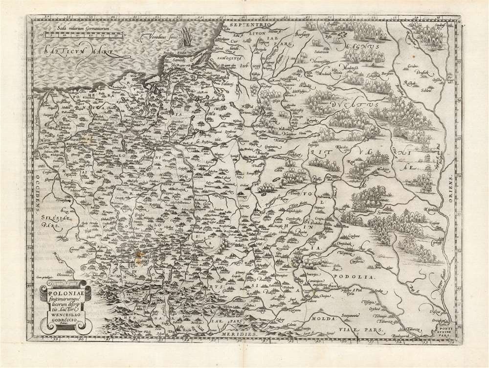
Poloniae finitimarumque locorum descriptio.
1570 (undated) 14.5 x 19.5 in (36.83 x 49.53 cm) 1 : 2500000
1570 (undated) 14.5 x 19.5 in (36.83 x 49.53 cm) 1 : 2500000
Description
This is Abraham Ortelius' 1581 map of Poland, based on the c. 1556-58 Grodziecki. The map reaches from Szczecin and the Oder River in the west to the Dnieper River, thus embracing much of Ukraine as well as part of Russia and the Baltic. Mountains and forests are shown pictorially.
Publication History and Census
This map was engraved for inclusion in Ortelius' Theatrum Orbis Terrarum in 1579. The present example conforms typographically to the 1581 French text edition, of which van den Broecke estimates there were four hundred printed. Nine examples of that edition of the book are listed in OCLC. The separate map is well represented in institutional collections.CartographerS
Abraham Ortelius (April 14, 1527 - June 28, 1598) also known as Ortels, was a cartographer, geographer, and cosmographer of Brabant, active in Antwerp. He was the creator of the first modern atlas, Theatrum Orbis Terrarum and is a seminal figure in the history of cartography. Along with Gerard Mercator and Gemma Frisius, he was a founder of the Netherlandish school of cartography. His connections with Spain - culminating in his 1575 appointment as Royal Cartographer to King Phillip II of Spain - gave him unmatched access to Spanish geographical knowledge during a crucial period of the Age of Discovery. Ortelius was born in 1527 in Antwerp. In 1547 he entered the Antwerp Guild of Saint Luke as an illuminator of maps. He began trading in books, prints, and maps, traveling regularly to the Frankfurt book and print fair, where in 1554 he met Mercator. He accompanied Mercator on journeys throughout France in 1560 and it was at this time, under Mercator's influence, that he appears to have chosen his career as a scientific geographer. His first published geographic work appeared in 1564, an eight-sheet cordiform world map. A handful of other maps preceded the 1570 publication of the first edition of the Theatrum Orbis Terrarum, which would prove to be his life work. Appearing with but 53 maps in its first edition, Ortelius' work expanded with new maps added regularly. By 1592, it had 134 maps. Many of Ortelius' maps remained the standard for nearly a century. He traveled extensively, but his genius was as a compiler, locating the best informed maps on which to base his own. His contacts throughout Europe and extending even (via the Portuguese) to the Far East were formidable. Moreover, many of his maps were based on his own scholarship, particularly his historical works. His theories of geography were particularly ahead of his time with respect to the notion of continental drift, the possibility of which he mused on as early as 1596, and which would be proven correct centuries later.
In a sense his greatest achievement was his successful navigation of the religious and political violence endemic to his city throughout his adult life: The Dutch Revolt, or Eighty Years' War (1568 - 1648), fully embroiled Antwerp. Although outwardly and officially recognized as Catholic (Arias Montanus vouched for Ortelius' Catholic orthodoxy prior to his appointment as Royal Geographer), Ortelius was able to separate himself from the religious furor which characterized the war in the low countries. Ortelius showed a glimpse of himself in a letter to a friend, regarding humanist Justus Lipsius: 'I do not know whether he is an adherent of the Pope or a Calvinist, but if he has ears to hear, he will neither be one nor the other, for sins are committed on both sides'. Ortelius' own explorations of Biblical history in his maps, and the Christogram contained in his own motto, suggest him to be a religious man, but his abjuration of political religious authorities mark him as an individualist. His tombstone at St Michael's Præmonstratensian Abbey in Antwerp bears the inscription, Quietis cultor sine lite, uxore, prole. ('served quietly, without accusation, wife, and offspring.') More by this mapmaker...
Wacław Grodziecki (or Grodecki) (c. 1535 - 1591) was a Polish Catholic priest, canon, and cartographer. He was born to the family of a Starost, a community elder; he studied mathematics and philosophy at Krakow Academy, and between 1556 and 1558 studied further at the university in Leipzig. He is thought to have travelled to Rome in 1558 and to have visited Prague in 1561. Having returned to Krakow, he graduated with a master's degree in liberal arts in 1564. Thereafter he became canon in several towns successively: Wrocław, Olomouc and Brno, where he and his brother Jan established a Jesuit college. In 1572, he became Olomouc's bishop. During his time in Leipzig, Grodziecki drew a map of Poland, published around 1562 in Basel; it is thought to have been derived from the 1526 map of Bernard Wapowski, but as virtually all of Wapowski's maps were destroyed in the fire of Kraków in 1528, Grodziecki's work was long the best map of Polish lands. It provided the model for Ortelius' 1570 map, to which Grodziecki's fame can largely be ascribed. Learn More...
Source
Ortelius, A., Theatre de l'univers, contenant les cartes de tout le monde, (Antwerp) 1581.
Condition
Excellent with a sharp strike.
References
OCLC 179744155. Rumsey 10000.097. Van der Krogt 1900:31A; Van den Broecke Ortelius Atlas Maps 154.