
This item below is out of stock, but another example (left) is available. To view the available item, click "Details."
Details
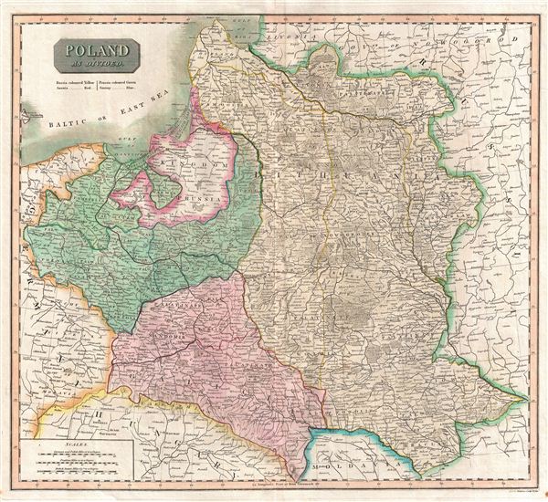
1814 Thomson Map of Poland
$400.00
1817 Thomson Map of Poland
Poland-thomson-1814$175.00

Title
Poland As Divided.
1817 (undated) 18 x 20 in (45.72 x 50.8 cm)
1817 (undated) 18 x 20 in (45.72 x 50.8 cm)
Description
This is an exceptionally fine example of John Thomson's 1817 map of Poland. Thomson's map of Italy covers Poland following the 1795 Third Partition of Poland between Austria, Germany, and Russia. Color coding identifies the powers that controlled each part of Poland with yellow representing Russia, Austrian claims in red, and German dominions in blue. This mapping corresponds to the 1815 Congress of Vienna, which, following the 1814 dissolution of Napoleon's Empire in Europe, reverted Poland to the 1795 borders. Relief is shown by hachure with towns, cities, and major topographical features identified. This map is a steel plate engraving by J. and G. Menzies and was prepared by John Thomson for inclusion in the 1817 edition of Thomson's New General Atlas.
Cartographer
John Thomson (1777 - c. 1841) was a Scottish cartographer, publisher, and bookbinder active in Edinburgh during the early part of the 19th century. Thomson apprenticed under Edinburgh bookbinder Robert Alison. After his apprenticeship, he briefly went into business with Abraham Thomson. Later, the two parted ways, John Thomson segueing into maps and Abraham Thomson taking over the bookbinding portion of the business. Thomson is generally one of the leading publishers in the Edinburgh school of cartography, which flourished from roughly 1800 to 1830. Thomson and his contemporaries (Pinkerton and Cary) redefined European cartography by abandoning typical 18th-century decorative elements such as elaborate title cartouches and fantastic beasts in favor of detail and accuracy. Thomson's principle works include Thomson's New General Atlas, published from 1814 to 1821, the New Classical and Historical Atlas of 1829, and his 1830 Atlas of Scotland. The Atlas of Scotland, a work of groundbreaking detail and dedication, would eventually bankrupt the Thomson firm in 1830, at which time their plates were sequestered by the court. The firm partially recovered in the subsequent year, allowing Thomson to reclaim his printing plates in 1831, but filed again for bankruptcy in 1835, at which time most of his printing plates were sold to A. K. Johnston and Company. There is some suggestion that he continued to work as a bookbinder until 1841. Today, Thomson maps are becoming increasingly rare as they are highly admired for their impressive size, vivid hand coloration, and superb detail. More by this mapmaker...
Source
Thomson, J. A New General Atlas, (Edinburgh) 1817.
Condition
Very good condition. Original centerfold exhibits some light toning and archival verso reinforcement. Light soiling to outer margins. Some offsetting or transference. Original platemark visible. Blank on verso.
References
Rumsey 1007.033. Malinowski, H., The Malinowski collection of Poland, 459. Phillips (Atlases) 731. Newberry Library: Ayer 135 T4 1817.