1814 Thomson Map of Poland
Poland-thomson-1814-2$400.00

Title
Poland.
1814 (dated) 18.75 x 22.75 in (47.625 x 57.785 cm) 1 : 2400000
1814 (dated) 18.75 x 22.75 in (47.625 x 57.785 cm) 1 : 2400000
Description
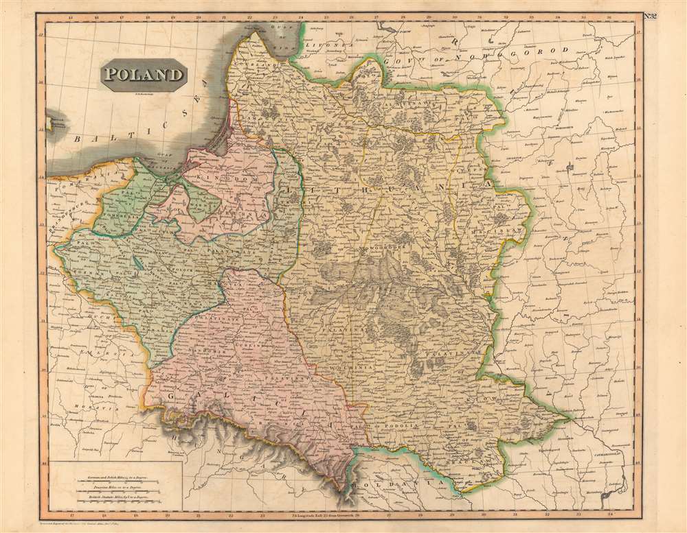
This is a fine example of John Thomson's 1814 map of Poland. It illustrates the lands of the former Polish-Lithuanian Commonwealth at the end of the Napoleonic Wars and on the cust of its partition betweem Russia, Prussia, and Austria.
After Napoleon's retreat, the Duchy of Warsaw effectively ceased to exist as the Russians fought against holdout forces and established a temporary military government. Soon after this map's publication, the 1815 Congress of Vienna determined the political fate of Poland. Russia demanded the whole lot given its outsize contribution to Napoleon's defeat, but the other European powers were aligned in opposition, with the issue becoming the most contentious of the entire congress.
In the end, a complicated arrangement effectively cut the Duchy of Warsaw in half between Russia and Prussia, which appears to have been anticipated by the color coding here (Galicia and surrounding areas shaded in pink had been annexed by Austria in 1772). Nominally, the new Prussian Duchy of Posen and Russian-ruled Kingdom of Poland maintained some autonomy and Kraków held 'free city' status, but in effect Poland ceased to exist, yet again, until 1918. With additional border changes in the 20th century, Poland 'shifted' considerably to the west; Warsaw, near left-center here is now in the eastern part of the country, while Brest, at center here, is no longer part of Poland at all but was at the western edge of the Soviet Union and now Belarus.
Poland - Stuck between Great Powers
The Polish-Lithuanian Commonwealth suffered at the hands of Russia, Prussia, and Austria in the 18th century when the three states conspired to reduce and then eliminate the commonwealth, a feat accomplished in 1795. But Polish nationalism had been enflamed by the American and French Revolutions, and the Napoleonic Wars offered an opportunity to recreate a Polish state. Following a popular uprising in 1806, Napoleon carved off a portion of Prussia to create the Duchy of Warsaw, which was established as a constitutional monarchy. However, the duchy was a French client state with limited autonomy, and was short lived in any case, having been occupied by Russia in 1813 following Napoleon's disastrous invasion of Russia the previous year.After Napoleon's retreat, the Duchy of Warsaw effectively ceased to exist as the Russians fought against holdout forces and established a temporary military government. Soon after this map's publication, the 1815 Congress of Vienna determined the political fate of Poland. Russia demanded the whole lot given its outsize contribution to Napoleon's defeat, but the other European powers were aligned in opposition, with the issue becoming the most contentious of the entire congress.
In the end, a complicated arrangement effectively cut the Duchy of Warsaw in half between Russia and Prussia, which appears to have been anticipated by the color coding here (Galicia and surrounding areas shaded in pink had been annexed by Austria in 1772). Nominally, the new Prussian Duchy of Posen and Russian-ruled Kingdom of Poland maintained some autonomy and Kraków held 'free city' status, but in effect Poland ceased to exist, yet again, until 1918. With additional border changes in the 20th century, Poland 'shifted' considerably to the west; Warsaw, near left-center here is now in the eastern part of the country, while Brest, at center here, is no longer part of Poland at all but was at the western edge of the Soviet Union and now Belarus.
Publication History and Census
This map is a steel plate engraving prepared by John Thomson and engraved by Nathaniel Rogers Hewitt for inclusion in the November 1814 edition ofThomson's New General Atlas. It is very similar but not identical to a map in the David Rumsey Map Collection (List No. 0732.021) dated to July 1814, showing that Thomson published two editions of the map in a single year to keep up with the rapidly changing situation. This edition of the map is held by a handful of libraries in North America and Europe and is scarce to the market.CartographerS
John Thomson (1777 - c. 1841) was a Scottish cartographer, publisher, and bookbinder active in Edinburgh during the early part of the 19th century. Thomson apprenticed under Edinburgh bookbinder Robert Alison. After his apprenticeship, he briefly went into business with Abraham Thomson. Later, the two parted ways, John Thomson segueing into maps and Abraham Thomson taking over the bookbinding portion of the business. Thomson is generally one of the leading publishers in the Edinburgh school of cartography, which flourished from roughly 1800 to 1830. Thomson and his contemporaries (Pinkerton and Cary) redefined European cartography by abandoning typical 18th-century decorative elements such as elaborate title cartouches and fantastic beasts in favor of detail and accuracy. Thomson's principle works include Thomson's New General Atlas, published from 1814 to 1821, the New Classical and Historical Atlas of 1829, and his 1830 Atlas of Scotland. The Atlas of Scotland, a work of groundbreaking detail and dedication, would eventually bankrupt the Thomson firm in 1830, at which time their plates were sequestered by the court. The firm partially recovered in the subsequent year, allowing Thomson to reclaim his printing plates in 1831, but filed again for bankruptcy in 1835, at which time most of his printing plates were sold to A. K. Johnston and Company. There is some suggestion that he continued to work as a bookbinder until 1841. Today, Thomson maps are becoming increasingly rare as they are highly admired for their impressive size, vivid hand coloration, and superb detail. More by this mapmaker...
Nathaniel Rogers Hewitt (July 19, 1783 - 1841) was a British engraver active in London during the first half of the 19th century. Hewitt was born in London on the 19th of July 1785. His map engraving work appears as early as 1804, although it is most commonly associated with the 1812 - 1817 atlas maps of publisher John Thomson. Hewitt also worked with James Wyld, Samuel William Fores, and other map publishers of the period. In 1824, Hewitt announced plans to independently publish a series of Parish maps by subscription, and a beautifully engraved map of St. Giles in the Fields followed. The map series must not have been able to attract many followers, as Hewitt declared bankruptcy shortly after in 1826. Learn More...
Source
Thomson, J. A New General Atlas, (Edinburgh) 1814.
Condition
Very good.
References
Rumsey 0732.021, OCLC 526599966.