
This item below is out of stock, but another example (left) is available. To view the available item, click "Details."
Details
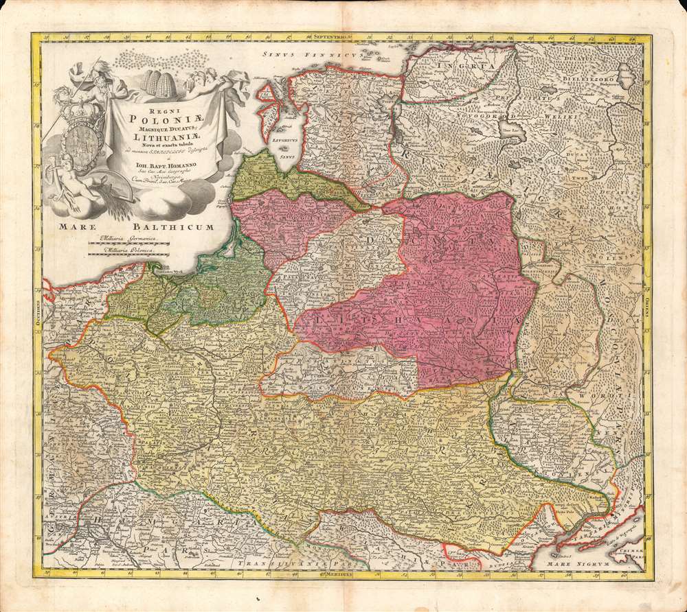
1707 Homann Map of Poland-Lithuania, the Baltic States
1707 (undated) $750.00
1720 Homann Map of Poland-Lithuania, the Baltic States
PolandLithuania-homann-1720$300.00

Title
Regni Poloniae magnique Ducatus Lithuaniae...
1720 (undated) 18.75 x 21.55 in (47.625 x 54.737 cm) 1 : 3100000
1720 (undated) 18.75 x 21.55 in (47.625 x 54.737 cm) 1 : 3100000
Description
Here is a fine example of Johann Baptist Homann's c. 1720 map of the Polish-Lithuanian Commonwealth, covering most of Eastern Europe. It was produced during a transition in the relative balance of power in the region, with Poland-Lithuania itself, Sweden, and the Ottoman Empire waning, and Russia, Prussia, and Austria on the rise.
A Closer Look
The lands of the Polish-Lithuanian Commonwealth are displayed, along with portions of neighboring territories belonging to the Russian and Ottoman Empires, as well as lands under the rule or influence of the Habsburgs. Homann wisely amalgamated the dozens of small and micro territories of the German lands into 'Germaniae Pars.' Rivers, lakes, mountains, forests, settlements, and major fortifications (such as those at Lublin and Krakow) are indicated. An elaborate cartouche with a coat of arms appears at top-left. Scales are provided in German and Polish miles, while Tenerife is employed as the prime meridian, an early example of its use in a Homann map (his Grosser Atlas, published in 1716, had set off a small revolution in cartographic methods).Poland-Lithuania
The fortunes of the Polish-Lithuanian Commonwealth changed quickly in the 17th-18th century, from a cultural and territorial peak in the early-mid 17th century to a period of crisis and instability. Rebellions and wars, especially with the Ottomans and Russians, sapped the county's finances and attention. The situation improved somewhat under the leadership of King John III Sobieski in the late 17th century, crowned by his decisive defeat of the Ottomans outside Vienna in 1683, but problems resurfaced after his death. In the following decades, both Poland-Lithuania and Sweden would decline as powers in northern and eastern Europe, to the benefit of Russia and Prussia.Publication History and Census
This map was produced by Johann Baptist Homann around the year 1720. Due to its multiple plates, states, and printings, there is wide variation in the date assigned in catalog listings and establishing an accurate census would be nearly impossible. The inclusion of the royal privilege under the title indicates a date between 1715 and 1730. The presence of St. Petersburg, just inside the border at top towards top-right, also suggests a date in the 1710s or 1720s (other, likely later, states of the map present St. Petersburg as a fortress, similar to the cities mentioned above).Cartographer
Johann Baptist Homann (March 20, 1664 - July 1, 1724) was the most prominent and prolific map publisher of the 18th century. Homann was born in Oberkammlach, a small town near Kammlach, Bavaria, Germany. As a young man, Homann studied in a Jesuit school and nursed ambitions of becoming a Dominican priest. Nonetheless, he converted to Protestantism in 1687, when he was 23. It is not clear where he mastered engraving, but we believe it may have been in Amsterdam. Homann's earliest work we have identified is about 1689, and already exhibits a high degree of mastery. Around 1691, Homann moved to Nuremberg and registered as a notary. By this time, he was already making maps, and very good ones at that. He produced a map of the environs of Nürnberg in 1691/92, which suggests he was already a master engraver. Around 1693, Homann briefly relocated to Vienna, where he lived and studied printing and copper plate engraving until 1695. Until 1702, he worked in Nuremberg in the map trade under Jacob von Sandrart (1630 - 1708) and then David Funck (1642 - 1709). Afterward, he returned to Nuremberg, where, in 1702, he founded the commercial publishing firm that would bear his name. In the next five years, Homann produced hundreds of maps and developed a distinctive style characterized by heavy, detailed engraving, elaborate allegorical cartouche work, and vivid hand color. Due to the lower cost of printing in Germany, the Homann firm could undercut the dominant French and Dutch publishing houses while matching their diversity and quality. Despite copious output, Homann did not release his first major atlas until the 33-map Neuer Atlas of 1707, followed by a 60-map edition of 1710. By 1715, Homann's rising star caught the attention of the Holy Roman Emperor Charles VI, who appointed him Imperial Cartographer. In the same year, he was also appointed a member of the Royal Academy of Sciences in Berlin. Homann's prestigious title came with several significant advantages, including access to the most up-to-date cartographic information as well as the 'Privilege'. The Privilege was a type of early copyright offered to very few by the Holy Roman Emperor. Though less sophisticated than modern copyright legislation, the Privilege offered limited protection for several years. Most all J. B. Homann maps printed between 1715 and 1730 bear the inscription 'Cum Priviligio' or some variation. Following Homann's death in 1724, the firm's map plates and management passed to his son, Johann Christoph Homann (1703 - 1730). J. C. Homann, perhaps realizing that he would not long survive his father, stipulated in his will that the company would be inherited by his two head managers, Johann Georg Ebersberger (1695 - 1760) and Johann Michael Franz (1700 - 1761), and that it would publish only under the name 'Homann Heirs'. This designation, in various forms (Homannsche Heirs, Heritiers de Homann, Lat Homannianos Herod, Homannschen Erben, etc.) appears on maps from about 1731 onwards. The firm continued to publish maps in ever-diminishing quantities until the death of its last owner, Christoph Franz Fembo (1781 - 1848). More by this mapmaker...
Condition
Good. Some wear along fold line. Foxing along top edge. Small areas of loss in top left and right corners. Old color.
References
Rumsey 12499.183. OCLC 495162405, 646118524, 931887724.