This item has been sold, but you can get on the Waitlist to be notified if another example becomes available, or purchase a digital scan.
1799 Laurie and Whittle Map of Poland and Lithuania after the Third Partition
PolandPrussia2-lauriewhittle-1799$450.00

Title
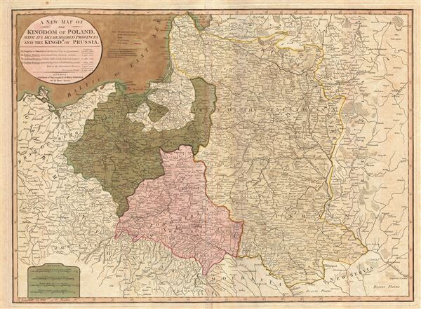
A New Map of the Kingdom of Poland, with its dismembered provinces and the Kingdm. of Prussia.
1799 (dated) 20 x 26.5 in (50.8 x 67.31 cm) 1 : 2400000
1799 (dated) 20 x 26.5 in (50.8 x 67.31 cm) 1 : 2400000
Description
This important 1799 map by Laurie and Whittle depicts the Kingdom of Poland following the 1795 Third Partition. The map covers from Brandenburg to Russia and from the Gulf of Livonia to Moldova and Hungary, including all of Poland and the former Grand Duchy of Lithuania, parts of Prussia, Russia, Livonia, Hungary, Germany and Austria. This map depicts Poland in 1799, four years following the 1795 Third Partition of Poland. Here Russia has annexed more the entire western half of the former Polish-Lithuanian Confederation. Austria seized the lands around Lwow and Krakow while Prussia claimed the territories to the north and west of Warsaw.
By the mid-18th century Poland, due to an inefficient and corrupt internal bureaucracy, had lost much of its autonomy to its aggressive and powerful neighbors: Russia, Austria and Prussia. The First Partition occurred in 1772 with Prussia occupying Poland's long coveted western territories, Austria seizing Galicia, and Russia taking part of Livonia. In the aftermath of the First Partition, the Second Partition was almost inevitable. Poland allied with Prussia to thwart the ambitions of Russia in the east. This, along with a number of other factors, lead to the War in Defense of the Constitution between Poland and Russia. Largely abandoned by their Prussian allies, Poland could not hope to stand against the powerful Russian military. Poland's defeat resulted in the loss of nearly 50% of its remaining territory to Russia and Prussia, who signed an accord in 1793. The Third Partition of Poland would dissolve what remained of the reduced Polish-Lithuanian Commonwealth, ending Polish all autonomy in the 18th century.
Variants of this map were published from before the First Partition of Poland to this, it's last state, following the Third Partition. The series provides a fascinating overview of the dramatic transformation and slow dissolution of Poland between 1772 and 1795. All text is in English. This map prepared London by the firm of Laurie and Whittle and based on an earlier map of the region by D'Anville. Published by Laurie and Whittle in 1799 from their office at 53 Fleet Street, London, England.
Cartographer
Laurie and Whittle (fl. 1794 - 1858) were London, England, based map and atlas publishers active in the late 18th and early 19th century. Generally considered to be the successors to the Robert Sayer firm, Laurie and Whittle was founded by Robert Laurie (c. 1755 - 1836) and James Whittle (1757-1818). Robert Laurie was a skilled mezzotint engraver and is known to have worked with Robert Sayer on numerous projects. James Whittle was a well-known London socialite and print seller whose Fleet Street shop was a popular haunt for intellectual luminaries. The partnership began taking over the general management of Sayer's firm around 1787; however, they did not alter the Sayer imprint until after Sayer's death in 1794. Apparently Laurie did most of the work in managing the firm and hence his name appeared first in the "Laurie and Whittle" imprint. Together Laurie and Whittle published numerous maps and atlases, often bringing in other important cartographers of the day, including Kitchin, Faden, Jefferys and others to update and modify their existing Sayer plates. Robert Laurie retired in 1812, leaving the day to day management of the firm to his son, Richard Holmes Laurie (1777 - 1858). Under R. H. Laurie and James Whittle, the firm renamed itself "Whittle and Laurie". Whittle himself died six years later in 1818, and thereafter the firm continued under the imprint of "R. H. Laurie". After R. H. Laurie's death the publishing house and its printing stock came under control of Alexander George Findlay, who had long been associated with Laurie and Whittle. Since, Laurie and Whittle has passed through numerous permeations, with part of the firm still extant as an English publisher of maritime or nautical charts, 'Imray, Laurie, Norie and Wilson Ltd.' The firm remains the oldest surviving chart publisher in Europe. More by this mapmaker...
Source
Laurie, R., and Whittle, J., A general atlas, describing the whole universe: being a complete collection of the most approved maps extant; corrected with the greatest care, and augmented from the latest discoveries, (London: Laurie and Whittle) 1799.
Condition
Very good. Original centerfold. Blank on verso. Some offsetting. Original platemark visible. Old color.
References
Rumsey 2310.048. OCLC 7160203. Phillips, P.L. (Atlases) 6008-22.