This item has been sold, but you can get on the Waitlist to be notified if another example becomes available, or purchase a digital scan.
1636 Jansson Map of the North Pole or Arctic Regions
PoliArctici-jansson-1637$750.00

Title
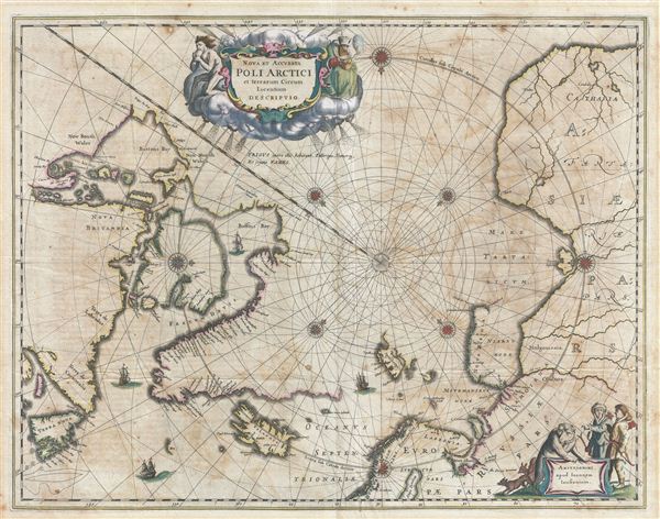
Nova et Accurata Poli Arctici et terrarum Circum Lacentium Descriptio.
1637 (undated) 16.5 x 21.5 in (41.91 x 54.61 cm)
1637 (undated) 16.5 x 21.5 in (41.91 x 54.61 cm)
Description
A first edition example of Joannes Jansson's important 1637 map of the North Pole or Arctic. Centered on the North Pole, this map extends southwards as far as James Bay, Newfoundland, Drontheim (Trondheim), and Lapland. It includes embryonic mappings of Greenland, Baffin Bay, Spitzbergen, and Nova Zembla as well as parts of Iceland, Siberia, Northern Russia, Canada, Norway, Sweden, and Finland. The unexplored northwestern parts of America are conveniently hidden by an allegorical title cartouche. Another cartouche in the lower right quadrant features stylized Arctic peoples, a polar bear, and two foxes.
One interesting feature of this map is its attempt to include rhumb lines. While common on more traditional maps, incorporating rhumb lines into a polar map is a logistical challenge due to the curvature of the earth. The present example solves this by replacing the traditional straight rhumb lines with a series of elaborately curved rhumbs – producing an impractical though highly decorative effect.
This map was first issued in the Appendix of the Latin edition of Novi Atlantis. It was subsequently issued five separate states and was republished until about 1694 when it was replaced by more advanced maps. Jansson's map of the Arctic was the model on which most Arctic maps were based well into the early 18th century. The current example, from the first edition plate, corresponds to the 1650 Latin edition of the Atlas Novus.
Cartographer
Jan Jansson or Johannes Janssonius (1588 - 1664) was born in Arnhem, Holland. He was the son of a printer and bookseller and in 1612 married into the cartographically prominent Hondius family. Following his marriage he moved to Amsterdam where he worked as a book publisher. It was not until 1616 that Jansson produced his first maps, most of which were heavily influenced by Blaeu. In the mid 1630s Jansson partnered with his brother-in-law, Henricus Hondius, to produce his important work, the eleven volume Atlas Major. About this time, Jansson's name also begins to appear on Hondius reissues of notable Mercator/Hondius atlases. Jansson's last major work was his issue of the 1646 full edition of Jansson's English Country Maps. Following Jansson's death in 1664 the company was taken over by Jansson's brother-in-law Johannes Waesberger. Waesberger adopted the name of Jansonius and published a new Atlas Contractus in two volumes with Jansson's other son-in-law Elizée Weyerstraet with the imprint 'Joannis Janssonii haeredes' in 1666. These maps also refer to the firm of Janssonius-Waesbergius. The name of Moses Pitt, an English map publisher, was added to the Janssonius-Waesbergius imprint for maps printed in England for use in Pitt's English Atlas. More by this mapmaker...
Source
Jansson, J. Atlas Novus, vol 5, c. 1650.
Condition
Good. Even overall toning. Centerfold repair limited to lower margin. A couple of minor marginal scrapes not affecting printed area. Some transference throughout. Some foxing.
References
Burden, P., The Mapping of America: A List of Printed Maps, 1151-1670, 250. Van der Krogt, P. C. J., Koeman's Atlantes Neerlandici, (3 Vols), 0020:1C. Kershaw, K. A., Early Printed Maps of Canada, 110 pl. 70. Goss, J., The Mapping of North America: Three Centuries of Map-Making 1500-1860, p. 26. National Maritime Museum, 282:1.