This item has been sold, but you can get on the Waitlist to be notified if another example becomes available, or purchase a digital scan.
1750 Homann Heirs Map of Poland
Poloniae-homannheirs-1750$375.00

Title
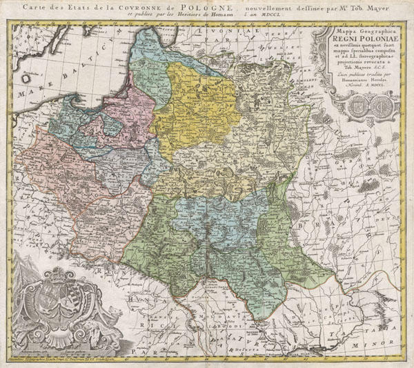
Mappa Geographica Regni Poloniae ex novissimis quotquot sunt mappis specialibus composita et al L.L. Stereographicae projectionis revocata a Tob. Mayero.
1750 18 x 21 in (45.72 x 53.34 cm)
1750 18 x 21 in (45.72 x 53.34 cm)
Description
This is one of the Homann Heirs finest and most appealing maps of Poland. Depicts the Poland extending north as far as Latvia, Lithuania, and the Lithuanian Sea and south as far as the Carpathian Mountains, Moldova, and Transylvania. Features two elaborate decorative cartouches, one in the upper right quadrant decorated with a Polish coin, and another in the lower left quadrant bearing the Polish armorial emblems. Additional French title outside top border: Carte des Etats de la Couronne de Pologne, nouvellement dessinee par Mr. Tob. Mayer. This map was drawn by Tob. Mayer for inclusion the 1752 Homann Heirs Maior Atlas Scholasticus ex Triginta Sex Generalibus et Specialibus…. Most early Homann atlases were 'made to order' or compiled of individual maps at the request of the buyer. However, this rare atlas, composed of 37 maps and charts, was issued as a 'suggested collection' of essential Homann Heirs maps. A fine copy of an important map.
Cartographer
Homann Heirs (1730 - 1848) were a map publishing house based in Nuremberg, Germany, in the middle to late 18th century. After the great mapmaker Johann Baptist Homann's (1664 - 1724) death, management of the firm passed to his son Johann Christoph Homann (1703 - 1730). J. C. Homann, perhaps realizing that he would not long survive his father, stipulated in his will that the company would be inherited by his two head managers, Johann Georg Ebersberger (1695 - 1760) and Johann Michael Franz (1700 - 1761), and that it would publish only under the name 'Homann Heirs'. This designation, in various forms (Homannsche Heirs, Heritiers de Homann, Lat Homannianos Herod, Homannschen Erben, etc..) appears on maps from about 1731 onwards. The firm continued to publish maps in ever diminishing quantities until the death of its last owner, Christoph Franz Fembo (1781 - 1848). More by this mapmaker...
Condition
Very Good condition. Very minor centerfold discoloration. Blank on verso.
References
Phillips, Lee Philip, A List of Geographical Atlases in the Library of Congress, Page 157.