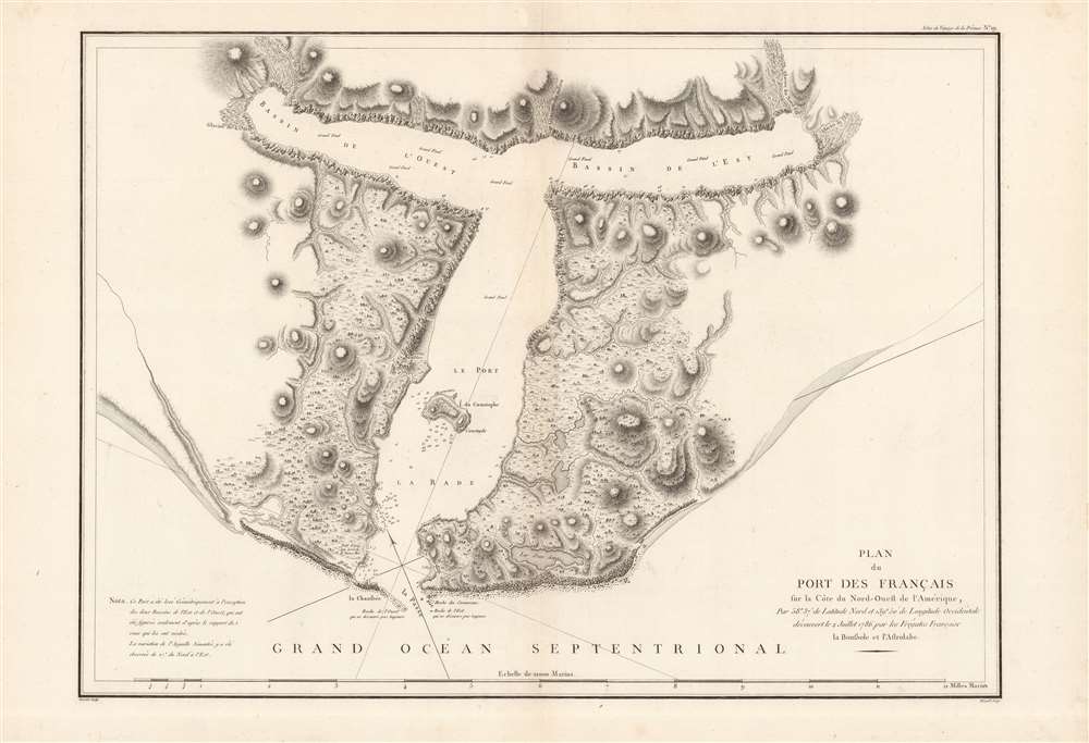
1786 La Perouse Map of Port de Français (Lituya Bay), Alaska
PortdesFranciasLituyaBay-perouse-1786$900.00

Title
Plan du Port des Francais.
1786 (undated) 21 x 29 in (53.34 x 73.66 cm) 1 : 36300
1786 (undated) 21 x 29 in (53.34 x 73.66 cm) 1 : 36300
Description
This is a fine example of La Perouse's important 1786 mapping of Lituya Bay, which he named 'Port des Français,' on the southern portion of the Alaska coastline. When drawn in 1786, La Perouse's map was the only available map of this region not based on the survey work of Captain Cook.
Lituya Bay is situated on the southern coast of Alaska not far from Juneau (about 115 miles as the crow flies). It is now a part of the Glacier Bay National Park and Preserve. The bay (or fjord) and nearby Lituya Mountain are known for their perilousness. Twenty-one of Perouse's men died while trying to navigate the tidal currents in Lituya Bay. It is also famous for being hit by tsunamis and landslides, including a megatsunami in 1958. When an earthquake caused a large mass of rock on the northeastern shore of the bay to drop from 3,000 feet, the rock crashing into the water created a wave over 1,700 feet high, a world record for a runup against a hillside.
A Closer Look
The map shows the very distinctively shaped bay (described in an explanatory note at bottom-left) and the Lituya Glacier which feeds into it. The unusual topography of the bay is defined by steep walls receding from the glacier, a very deep submerged bottom, and a narrow entrance to the ocean.Lituya Bay is situated on the southern coast of Alaska not far from Juneau (about 115 miles as the crow flies). It is now a part of the Glacier Bay National Park and Preserve. The bay (or fjord) and nearby Lituya Mountain are known for their perilousness. Twenty-one of Perouse's men died while trying to navigate the tidal currents in Lituya Bay. It is also famous for being hit by tsunamis and landslides, including a megatsunami in 1958. When an earthquake caused a large mass of rock on the northeastern shore of the bay to drop from 3,000 feet, the rock crashing into the water created a wave over 1,700 feet high, a world record for a runup against a hillside.
Publication History and Census
This map was drawn by La Perouse in 1786 and published posthumously as Plate No. 19 in the first edition of the Atlas du Voyage de la Perouse. It was engraved by Bouclet, edited by Hérault (no further information is available on these individuals), and published in Paris by the Imprimerie de la Republique in 1797 (Year 5 of the revolutionary regime). Due to variations in cataloging the map, it is difficult to precisely determine its distribution, but both the map and the entire atlas are known to be held by a handful of libraries in North America and Europe.Cartographer
Jean François de Galaup, Comte de La Pérouse (August 23, 1741 - 1788) was a French naval officer, navigator, and explorer active in the later part of the 18th century. Born into a noble family of Albi, France, La Perouse entered the navel college of Brest at just 15. At seventeen La Perouse made his first naval voyage, a supply expedition to the fort of Louisbourg in New France. He later participated in a number of naval battles, mostly against the English, and eventually rose to the rank of Commodore. In 1782 he captured the English forts Prince of Wales and York, making a name for himself back in France. Following the British defeat at the end of the American Revolutionary War, La Perouse was appointed by Louis XVI to lead an expedition of discovery circumnavigating the globe. The goal of the expedition was to complete and correct the maps of the Pacific drawn by Captain Cook. La Perouse's two frigates, the Astrolabe and the Boussole rounded Cape Horn and entered the Pacific in 1785. Crisscrossing the Pacific from Macau and Japan to Alaska, Vancouver, and the Hawaiian Islands Perouse made numerous discoveries and adding considerably to the cartographic corpus, particularly along the coast of British Columbia and around Japan. In Australia La Perouse sent his last letter back to France containing all of his maps and research. Tragically, on the return voyage La Perouse ran into a violent storm which left both of his frigates shipwrecked on the Polynesian island of Vanikoro, part of the Santa Cruz Group. Some of the survivors of the shipwrecks seem to have managed to live on the island for years afterwards. As late as 1790 the English Captain Edward Edwards saw smoke signals coming from Vanikoro but foolishly declined to investigate. Expeditions in 2005 and in 2008 identified the remains of both ships and retuned numerous artifacts from the ill-fated expedition to France. The importance of La Perouse's discoveries was, unfortunately, not seriously appreciated until many years later because, when the La Perouse maps were finally published in 1797, newer more accurate maps of the region were already in circulation. Nonetheless, La Perouse remains of the titans of Pacific exploration and he work paved the path forward for all future expeditions to the region. More by this mapmaker...
Source
Jean-François de Galaup La Pérouse, comte de, Atlas du voyage de La Perouse, (Paris: Imprimerie de la République) 1797.
Condition
Very good.
References
Rumsey 3355.019.