This item has been sold, but you can get on the Waitlist to be notified if another example becomes available, or purchase a digital scan.
1866 U. S. Coast Survey Map of Portsmouth Harbor, New Hampshire
PortsmouthHarbor-uscs-1866$200.00

Title
Portsmouth Harbor New Hampshire
1866 (dated) 19.5 x 27 in (49.53 x 68.58 cm) 1 : 20000
1866 (dated) 19.5 x 27 in (49.53 x 68.58 cm) 1 : 20000
Description
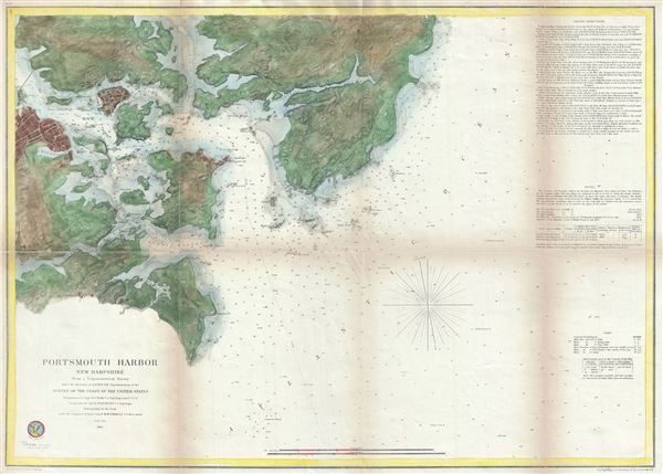
This is a beautiful example of the U.S. Coast Survey's 1866 nautical chart or maritime map of Portsmouth Harbor, New Hampshire. It covers the city of Portsmouth, New Hampshire, and its vicinity from Odiornes Point and Sagamore Creek to Chauncy's Creek and Spruce Creek. It includes Great Island, the Navy Year, Kittery Maine, and countless smaller islands. This 1866 map represents the culmination of the Coast Survey's work in the vicinity of Portsmouth. Unlike earlier issues, this example presents rich topographical detail as well as hydrographical data. There are countless depth soundings throughout and the right-hand quadrants feature sailing instructions, notes on tides and light houses, and a wealth of other practical information for the mariner. The city of Portsmouth itself is beautifully illustrated with numerous individual buildings and all major streets rendered.
The triangulation for this map is the work of T. J. Cram. The Topography was completed by H. Stansbury. The hydrography was accomplished by parties under the command of M. Woodhull. Stansbury, it should be noted, had previously completed the first accurate survey of Great Salt Lake in anticipation of a transcontinental railroad and is one of the most important cartographers in American history. Though this chart is a minor production compared to his other pieces, his association with it bears note. This chart was published three years after Stansbury's death, so we can assume that it must have been one of his final projects for the Army Corps of Engineers. The whole was compiled under the supervision of A. D. Bache, one of the most influential American cartographers of the 19th century.
The triangulation for this map is the work of T. J. Cram. The Topography was completed by H. Stansbury. The hydrography was accomplished by parties under the command of M. Woodhull. Stansbury, it should be noted, had previously completed the first accurate survey of Great Salt Lake in anticipation of a transcontinental railroad and is one of the most important cartographers in American history. Though this chart is a minor production compared to his other pieces, his association with it bears note. This chart was published three years after Stansbury's death, so we can assume that it must have been one of his final projects for the Army Corps of Engineers. The whole was compiled under the supervision of A. D. Bache, one of the most influential American cartographers of the 19th century.
CartographerS
The Office of the Coast Survey (1807 - present) founded in 1807 by President Thomas Jefferson and Secretary of Commerce Albert Gallatin, is the oldest scientific organization in the U.S. Federal Government. Jefferson created the "Survey of the Coast," as it was then called, in response to a need for accurate navigational charts of the new nation's coasts and harbors. The spirit of the Coast Survey was defined by its first two superintendents. The first superintendent of the Coast Survey was Swiss immigrant and West Point mathematics professor Ferdinand Hassler. Under the direction of Hassler, from 1816 to 1843, the ideological and scientific foundations for the Coast Survey were established. These included using the most advanced techniques and most sophisticated equipment as well as an unstinting attention to detail. Hassler devised a labor intensive triangulation system whereby the entire coast was divided into a series of enormous triangles. These were in turn subdivided into smaller triangulation units that were then individually surveyed. Employing this exacting technique on such a massive scale had never before been attempted. Consequently, Hassler and the Coast Survey under him developed a reputation for uncompromising dedication to the principles of accuracy and excellence. Unfortunately, despite being a masterful surveyor, Hassler was abrasive and politically unpopular, twice losing congressional funding for the Coast Survey. Nonetheless, Hassler led the Coast Survey until his death in 1843, at which time Alexander Dallas Bache, a great-grandson of Benjamin Franklin, took the helm. Bache was fully dedicated to the principles established by Hassler, but proved more politically astute and successfully lobbied Congress to liberally fund the endeavor. Under the leadership of A. D. Bache, the Coast Survey completed its most important work. Moreover, during his long tenure with the Coast Survey, from 1843 to 1865, Bache was a steadfast advocate of American science and navigation and in fact founded the American Academy of Sciences. Bache was succeeded by Benjamin Pierce who ran the Survey from 1867 to 1874. Pierce was in turn succeeded by Carlile Pollock Patterson who was Superintendent from 1874 to 1881. In 1878, under Patterson's superintendence, the U.S. Coast Survey was reorganized as the U.S. Coast and Geodetic Survey (C & GS) to accommodate topographic as well as nautical surveys. Today the Coast Survey is part of the National Oceanic and Atmospheric Administration or NOAA as the National Geodetic Survey. More by this mapmaker...
Howard Stansbury (February 8, 1806 - April 13, 1863) was an important surveyor, cartographer, and explorer who did his most important work in Utah during the middle part of the 19th century. Born in New York City, Stansbury trained to be a Civil Engineer. Shorty after getting married to Helen Moody of Detroit in 1827, Stansbury took a position with the United States Topographical Bureau. Under that organization he surveyed the James River in 1836, and the Illinois and Kaskaskia Rivers in 1837. In 1838, he oversaw the construction of a road from Milwaukee to the Mississippi River. Later in 1838, when the U.S Corps of Topographical Engineers was created, he joined as a first Lieutenant. With the Topographical Engineers he surveyed the Great Lakes, the harbor of Portsmouth, New Hampshire, and constructed Florida's Carysfort Reef Lighthouse. During the Mexican-American War he constructed fortification in the Dry Tortugas at the westernmost point on the Florida Keys. Upon achieving the rank of Captain, Stansbury received a commissioned to head a survey of the Great Basin that would ultimately become the crowning achievement of his career. His assignment was to survey the emigrant trails to California, including the Oregon Trail, as well as the Great Salt Lake, and report on the status of the growing Mormon Community in Salt Lake City. Working with J. W. Gunnison and Alfred Carrington, a Mormon scout, Stansbury produced a masterful survey of the region that had a lasting effect not only on the development of the Great Basin, but on the development of the west in general. Upon completion of his survey, Stansbury set out on the road to Washington, completing another important survey in the process. On the way, he fell off his horse, taking an injury from which he never fully recovered. Following the presentation of his report to Congress, Stansbury was charged with additional survey work around the Great Lakes. Upon the outbreak of the American Civil War, he was assigned to recruitment duties in Ohio and later Wisconsin. Shortly after starting work at this post he suffered an abrupt heart attack and passed away. He is buried in St. Paul, Minnesota. Learn More...
Source
Bache, A. D., Report of the Superintendent of the United States Coast Survey, (Washington) 1866.
Condition
Very good. Some damage and toning along original fold lines. Backed on archival tissue.