This item has been sold, but you can get on the Waitlist to be notified if another example becomes available, or purchase a digital scan.
1926 U.S. Coast and Geodetic Survey Map of Field Work in the Philippines
ProgressPhilippines-uscgs-1926$62.50

Title
U.S. Coast and Geodetic Survey Progress of Field Work Philippine Islands Fiscal Year 1926.
1926 (dated) 30 x 20.25 in (76.2 x 51.435 cm) 1 : 2550000
1926 (dated) 30 x 20.25 in (76.2 x 51.435 cm) 1 : 2550000
Description
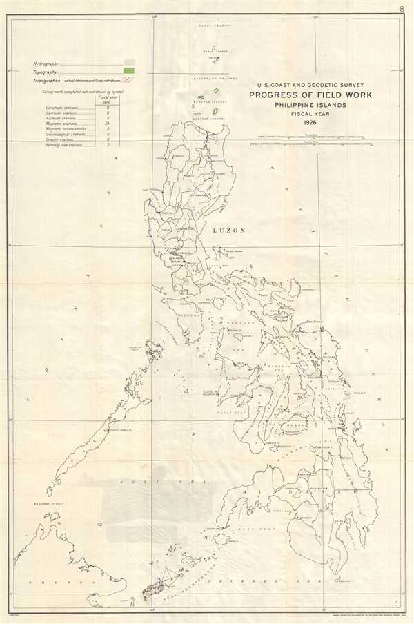
This is a 1926 U.S. Coast and Geodetic Survey map of the Philippines. The map depicts the Philippine Islands from the Bashi Channel to the Sulu Archipelago, the Celebes Sea, and Borneo and from the China Sea to the Pacific Ocean. Created for the Annual Report of the Director, United States Coast and Geodetic Survey of 1926, field work accomplished by the agency that year is illustrated, using different forms of notation. Hydrographic work, completed in the Sulu Sea and around the Babuyan, is presented by shading the area in a slightly darker shade of gray. Topographic work was finished in the Babuyan Islands and the Sulu Archipelago, as noted by the green shading. Triangulation surveys, denoted by the red lines, were completed in an area of northern Luzon, on several islands in the Sulu Archipelago, and in a small region of Palawan. A key is in the upper left corner, explaining the differences in shading and notations. Just below the key is a table which lists the different stations that had been set up by the agency during Fiscal Year 1926. In the Philippines these included 29 magnetic stations and three primary tide stations.
In addition to the information pertaining to field work completed by the U.S. Coast and Geodetic Survey, all of the islands in the region are labeled, as well as numerous straits and seas. Several cities are labeled, such as Cabanatuan and Manila on Luzon and Capiz on Panay. Rivers are depicted, although they are not labeled.
This map was produced by the U.S. Coast and Geodetic Survey for inclusion in the Annual Report of the Director of the Coast and Geodetic Survey. The director in 1926 was E. Lester Jones.
Cartographer
The Office of the Coast Survey (later the U.S. Geodetic Survey) (1807 - present), founded in 1807 by President Thomas Jefferson and Secretary of Commerce Albert Gallatin, is the oldest scientific organization in the U.S. Federal Government. Jefferson created the "Survey of the Coast," as it was then called, in response to a need for accurate navigational charts of the new nation's coasts and harbors. The first superintendent of the Coast Survey was Swiss immigrant and West Point mathematics professor Ferdinand Hassler. Under the direction of Hassler, from 1816 to 1843, the ideological and scientific foundations for the Coast Survey were established. Hassler, and the Coast Survey under him developed a reputation for uncompromising dedication to the principles of accuracy and excellence. Hassler lead the Coast Survey until his death in 1843, at which time Alexander Dallas Bache, a great-grandson of Benjamin Franklin, took the helm. Under the leadership A. D. Bache, the Coast Survey did most of its most important work. During his Superintendence, from 1843 to 1865, Bache was steadfast advocate of American science and navigation and in fact founded the American Academy of Sciences. Bache was succeeded by Benjamin Pierce who ran the Survey from 1867 to 1874. Pierce was in turn succeeded by Carlile Pollock Patterson who was Superintendent from 1874 to 1881. In 1878, under Patterson's superintendence, the U.S. Coast Survey was reorganized as the U.S. Coast and Geodetic Survey (C & GS or USGS) to accommodate topographic as well as nautical surveys. Today the Coast Survey is part of the National Oceanic and Atmospheric Administration or NOAA. More by this mapmaker...
Source
Jones, E. Lester, Annual Report of the Director, United States Coast and Geodetic Survey to the Secretary of Commerce for the Fiscal Year Ended June 30, 1926 (Washington: Government Printing Office) 1926.
Condition
Very good. Slight wear along original fold lines. Blank on verso.