This item has been sold, but you can get on the Waitlist to be notified if another example becomes available, or purchase a digital scan.
1815 Thomson Map of Prussia and its Dominions
PrussianDominions-thomson-1815$125.00

Title
Prussian Dominions.
1815 (dated) 20.25 x 24 in (51.435 x 60.96 cm)
1815 (dated) 20.25 x 24 in (51.435 x 60.96 cm)
Description
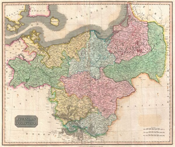
This fascinating hand colored 1815 map by Edinburgh cartographer John Thomson depicts Prussia (central and northern Europe). In 1815 Prussia emerged from the Napoleonic Wars and the Congress of Vienna as the dominant Germanic power. Its new borders included much of the Kingdom of Saxony, Rhineland, and Poland. In subsequent years Prussia would take a leading role in governing the German Confederation. The whole is beautifully engraved in the minimalist English style pioneered in the early part of the 19th century. Thomson maps are known for their stunning color, awe inspiring size, and magnificent detail. Thomson's work, including this map, represents some of the finest cartographic art of the 19th century. Relief is shown by hachure with towns, cities, and major topographical features identified. Engraved in 1815 and issued as plate no. 22 in the 1817 edition of Edinburgh cartographer John Thomson's New General Atlas.
Cartographer
John Thomson (1777 - c. 1841) was a Scottish cartographer, publisher, and bookbinder active in Edinburgh during the early part of the 19th century. Thomson apprenticed under Edinburgh bookbinder Robert Alison. After his apprenticeship, he briefly went into business with Abraham Thomson. Later, the two parted ways, John Thomson segueing into maps and Abraham Thomson taking over the bookbinding portion of the business. Thomson is generally one of the leading publishers in the Edinburgh school of cartography, which flourished from roughly 1800 to 1830. Thomson and his contemporaries (Pinkerton and Cary) redefined European cartography by abandoning typical 18th-century decorative elements such as elaborate title cartouches and fantastic beasts in favor of detail and accuracy. Thomson's principle works include Thomson's New General Atlas, published from 1814 to 1821, the New Classical and Historical Atlas of 1829, and his 1830 Atlas of Scotland. The Atlas of Scotland, a work of groundbreaking detail and dedication, would eventually bankrupt the Thomson firm in 1830, at which time their plates were sequestered by the court. The firm partially recovered in the subsequent year, allowing Thomson to reclaim his printing plates in 1831, but filed again for bankruptcy in 1835, at which time most of his printing plates were sold to A. K. Johnston and Company. There is some suggestion that he continued to work as a bookbinder until 1841. Today, Thomson maps are becoming increasingly rare as they are highly admired for their impressive size, vivid hand coloration, and superb detail. More by this mapmaker...
Source
Thomson, J. A New General Atlas, (Edinburgh) 1815.
Condition
Very good condition. Original centerfold exhibits some light toning . Light soiling to outer margins. Original platemark visible. Blank on verso.
References
Rumsey 1007.032. Phillips (Atlases) 731. Newberry Library: Ayer 135 T4 1817.