
1840 / 1878 Moreno 'Deposito Hidrografico' Map of Puerto Rico (Porto Rico)

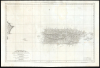
Carta Esferica De La Isla De Puerto-Rico y las adyacentes, que a la misma pertenecen Vicques, Culebra, Cajades Muertos, Mona, Monito y Desecho, con partie de las islas de Santa Domingo y Saona…
First Accurate Chart and Map of Puerto Rico.
- Digital Map Information
- Suitable for large format printing
- Full resolution TIFF file
- ICC color profile embedded
- Delivered instantly via download link
First Accurate Chart and Map of Puerto Rico.
An elegant, large nautical chart and topographical map of Puerto Rico, first published in 1840 by Miguel Moreno of the Spanish Depósito Hidrográfico. While presented as a nautical chart, both the coasts and interior of the island are scientifically precise and rich with detail. This is the first such map of Puerto Rico, surpassing the 1791 Tomas Lopez map, which had been considered the best map of Puerto Rico for nearly 50 years.A Closer Look
The map's coverage extends from western Santo Domingo (Dominican Republic) to the islands of Vieques and Culebra, east of Puerto Rico. The coastline is marked with depth soundings and anchorages. Letters keyed to a legend indicating the consistency of the ocean bottoms (essential information for choosing anchorages). Beacons are marked with hand color.The interior shows topography with hachure; rivers are shown with remarkable precision (particularly as compared with earlier works), and there are numerous placenames well away from the coast, also well placed. Areas of cultivation and salt pans are indicated.
Significantly Updated
Three beacons are indicated with color at Punta del Aguila, Puerto Ponce, and Cabeza de S. Juan. (Oddly, not at the Castel del Morro, which added a lighthouse in 1843). The present example has been updated through 1878; this is most evident in the easternmost extent of the chart, where the entire archipelago bounded by Vieques and Culebra Islands has been completely resurveyed, including the shapes of those islands and the eastern Puerto Rico coastline itself. A shallow is newly indicated to the south of Guyama. A note on the west coast of Puerto Rico indicates a more general (and grave) error, that according to a correction made in 1863, the entire western part of the island was found to be presented four minutes too far to the east. (Isla Mona, between Puerto Rico and Santo Domingo, has had its whole position reworked according to the same correction). The east coasts of Santo Domingo and Isla Saona have been fully reworked. Outside the harbor of Ponce, a shipwreck is noted: The Tasmanian, which took water and sank on May 29, 1878. Most of its cargo and passengers were safely unloaded: tantalizingly, the June 2, 1878 Boletin Mercantil de Puerto Rico indicated that in its cargo were 'dos millones en barras de oro.'Manuscript Notations
This is a working chart, and shows use. Pencil notations indicate the distances from which the abovementioned beacons could be seen. Several headings are marked between Punta del Aguila and Puerto Ponce; others are sketched north from Punta San Francisco and the Isla del Desecheo. Five headings are marked to the north, centered on the Castello del Morro.Publication History and Census
This map was published by the Depósito Hidrográfico in 1840. It was drawn by Miguel Moreno, who was a pilot and draftsman on the Cosme Damián Churruca expedition to South America and the West Indies (1792 - 1795) - during which the basic reconnaissance for this map was possibly completed. It was engraved by Depósito Hidrográfico engrave Juan Carrafa, with the lettering completed by Nicolás de Gangoiti. We are aware of subsequent updated and revised editions in 1848, 1854, 1878, and 1897, and there are certainly more: the present example is marked as the ninth revision, of 1878. This map appears on the market from time to time in various editions. We see 9 examples cataloged in institutional collections; clearly, more editions of this useful and excellent chart were produced than have survived.Cartographers
The Direccion Hidrografía (1787 - 1927), also known as the Deposito Hydrografico and the Direction de Hidrografía, was the Spanish equivalent of the British Admiralty or the U.S. Coast Survey. This organization, founded in 1787, was commissioned to collect and produce accurate nautical charts of all waters frequented by Spanish vessels. In essence, it replaced the Casa de la Contratación de las Indias (House of Trade of the Indies), which closed its doors in 1790. Like most such organizations, the Direccion Hidrografía marked a new age in cartography. Rather than simply collect charts created by navigators, explorers, and merchants, the Direccion Hidrografía worked closely with naval and military personnel to mount cartographic and hydrographic expeditions in pursuit of the most accurate hydrographical, astronomical, and geodetic measurements. The Direccion Hidrografía created a massive library of nautical charts that, though not nearly as common as similar nautical charts by the U.S. Coast Survey and British Admiralty, are highly desirable for the beauty of their manufacture as well as their accuracy and detail. The office was originally located on Calle Ballesta, but relocated to 36 Alcala, both in Madrid. After 1908 the Dirección was subsumed into other governmental agencies. In 1927 the Direccion was absorbed into the Institute and Observatory of San Fernando, located in Cadiz. The library of original maps, charts, and journals was transferred to the Naval Museum of Madrid - where it resides to this day. Further Details...
Miguel Moreno (fl. c. 1792 - 1845) was a Spanish cartographer and draftsman active with the Depósito Hidrográfico in Madrid during the first half of the 19th century. Hs served in the Spanish royal navy as a pilot as early as 1808. By 1807 he was producing nautical charts for the Depósito Hidrográfico. He participated in the geographical expedition to South America of Cosme Damián Churruca (1792 - 95), which included the Antilles. Moreno was widely considered the Depósito Hidrográfico's primary expert on the Gulf Coast and Puerto Rico. Further Details...
Juan Carrafa (1787 - June 19, 1869) was a Spanish cartographer and engraver active with the Depósito Hidrográfico in Madrid during the first half of the 19th century. He work primarily consists of nautical charts. Further Details...
Nicolás de Gangoiti (September 30, 1801 - January 6, 1857) was a Spanish artist and engraver active in Madrid during the early 19th century. Gangoiti was born in Madrid, the son of the Spanish artist, line and letter engraver Pedro Manuel de Gangoiti. Nicolás probably mastered letter engraving under his father's tutelage, and later studied under the painter Vincente López. Although he wanted to pursue a career as a painter, his father's declining health and advanced age, forced him to take up the more lucrative engraving profession. He worked extensively as a letter engraver for the Depósito Hidrográfico. He was the older brother of Juan Gangoiti (July 12, 1816 - February 8, 1878), also an artist and engraver. Further Details...
Condition
Good. A few minor discolorations. Closed split to centerfold at the top; some scuffing to centerfold near center.
References
OCLC: 557204016