This item has been sold, but you can get on the Waitlist to be notified if another example becomes available, or purchase a digital scan.
1879 Imray Nautical Chart or Map of Puerto Rico and the Virgin Islands
PuertoRicoVirginIslands-imray-1879$2,000.00

Title
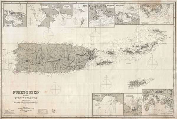
Puerto Rico and the Virgin Islands Compiled from Recent Government Surveys.
1879 (dated) 34 x 51 in (86.36 x 129.54 cm) 1 : 294000
1879 (dated) 34 x 51 in (86.36 x 129.54 cm) 1 : 294000
Description
An expansive, exceptional, and extremely rare 1879 nautical chart or maritime map of Puerto Rico and the Virgin Islands. This is the largest and finest map specific map of Puerto Rico we have yet encountered. The chart covers the island in great detail, offering both nautical and inland detail, including topography rivers, and political divisions. The focus of the chart, however, are the seas around the Virgin Islands between Puerto Rico and Anegada, where treacherous reefs abound. The map offers detailed hundreds of soundings in fathoms as well as shading to indicate dangerous howls and banks. There are 10 inset map detailed harbor plans, including San Juan, Mayagüez, Guánica, Mona Island, Sombrero Island, Road Harbour, Gorda Sound, the southeast end of Culebra, Ponce, Christiansted, and Saint Thomas.
This map is extremely rare and we are aware of only one other example, in private hands. No examples are noted on the OCLC. This map is owned jointly by Geographicus and Vetus Carta Maps.
This map is extremely rare and we are aware of only one other example, in private hands. No examples are noted on the OCLC. This map is owned jointly by Geographicus and Vetus Carta Maps.
Cartographer
James Imray (May 16, 1803 - November 15, 1870) was a Scottish hydrographer and stationer active in London during the middle to latter part of the 19th century. Imray is best known as a the largest and most prominent producer of blue-back charts, a kind of nautical chart popular from about 1750 to 1920 and named for its distinctive blue paper backing (although not all charts that may be called "blue-backs" actually have a blue backing). Unlike government charts issued by the British Admiralty, U.S. Coast Survey, and other similar organizations, Imray's charts were a private profit based venture and not generally the result of unique survey work. Rather, Imray's charts were judicious and beautiful composites based upon pre-existing charts (some dating to the 17th century) and new information gleaned from governmental as well as commercial pilots and navigators. Imray was born in Spitalfields, England, the eldest son of a Jacobite dyer also named James. Imray did not follow his father profession, instead apprenticing to William Lukyn, a stationer. He established himself as a bookseller and bookbinder at 116 Minories Street, where he shared offices with the nautical chart publisher Robert Blanchford. In 1836 Imray signed on as a full partner in Blanchford's enterprise, christening themselves Blanchford & Imray. At this time the Blanchford firm lagged far behind competing chart publishers Norie and Laruie, nevertheless, with the injection of Imray's marketing savvy the firm began a long rise. James Imray bought out Blanchford's share in 1846, becoming the sole proprietor of the chart house, publishing under the imprint of James Imray. Relocating in 1850 to larger offices at 102 Minories, Imray was well on track to become the most prominent chart publisher in London. In 1854, when Imray's 25 year old son, James Frederick Imray, joined as a full partner, the firm again changed its imprint, this time to James Imray and Son. The elder Imray was a master of marketing and was quick to respond to trade shifts and historic events. Many of his most successful charts were targeted to specific trade routes, for example, he issued charts entitled "Cotton Ports of Georgia" and "Rice Ports of India". Other charts emerged quickly following such events as the 1849 California Gold Rush. Imray's rise also coincided with the development of governmental mapping organizations such as the Admiralty and the U.S. Coast Survey, whose work he appropriated and rebranded in practical format familiar to navigators. Imray's death in 1870 marked a major transition in the firm's output and began its decline. Though Imray's son, James Frederick, excelled at authoring pilot books he had little experience with charts and issued few new publications. Most James Frederick Imray publications issued from 1870 to 1899 were either revisions of earlier maps prepared by his father or copies of British Admiralty charts. Charts from this period are recognizable as being less decorative than the elder Imray's charts following the stylistic conventions established by the Admiralty. The Admiralty itself at the same time began to rise in prominence, issuing its own official charts that were both cheaper and more up to date than those offered by private enterprises. By the end of the century the firm was well in decline and, in 1899 "James Imray and Son" amalgamated with the similarly suffering "Norie and Wilson", which was itself acquired by Laurie in 1904. Today it continues to publish maritime charts as "Imray, Laurie, Norie and Wilson". More by this mapmaker...
Condition
Very good. Some creasing. Minor stains near title. Backed on blue paper.